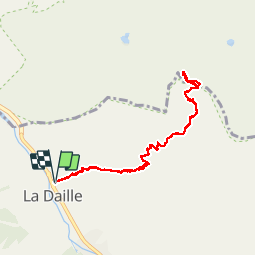
![](/images/other/stat-length.png)
(Pointe) et passage de Picheru
amiral13
Utilisateur GUIDE
![Longueur](/images/other/stat-length.png)
![Altitude max](https://static1.geolcdn.com/siteimages/upload/files/1508320355ic_sort_altitude_max_24dp.png)
![Dénivelé positif](https://static1.geolcdn.com/siteimages/upload/files/1508320355ic_sort_den_pos_24dp.png)
![Km-Effort](/images/other/stat-length.png)
![Altitude min](https://static1.geolcdn.com/siteimages/upload/files/1508320355ic_sort_altitude_min_24dp.png)
![Dénivelé négatif](https://static1.geolcdn.com/siteimages/upload/files/1508320355ic_sort_den_neg_24dp.png)
![Boucle](https://static1.geolcdn.com/siteimages/upload/files/16400158638029165_repeat_loop_refresh_sync_direction_icon.png)
![Marche](https://static1.geolcdn.com/sitytour/trail-icons/101.png)
3h53
Difficulté : Difficile
![Scannez ce code QR pour ouvrir la randonnée dans l'application SityTrail](https://capi.geolives.com/qq0zvz2zws4bq2lad0pu/sitytour/trails/336388/qr.png?size=200)
Application GPS de randonnée GRATUITE
À propos
Randonnée Marche de 9,3 km à découvrir à Auvergne-Rhône-Alpes, Savoie, Val-d'Isère. Cette randonnée est proposée par amiral13.
Description
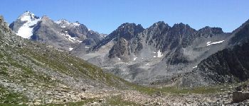
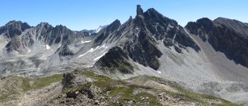
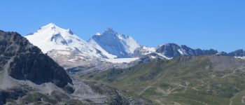
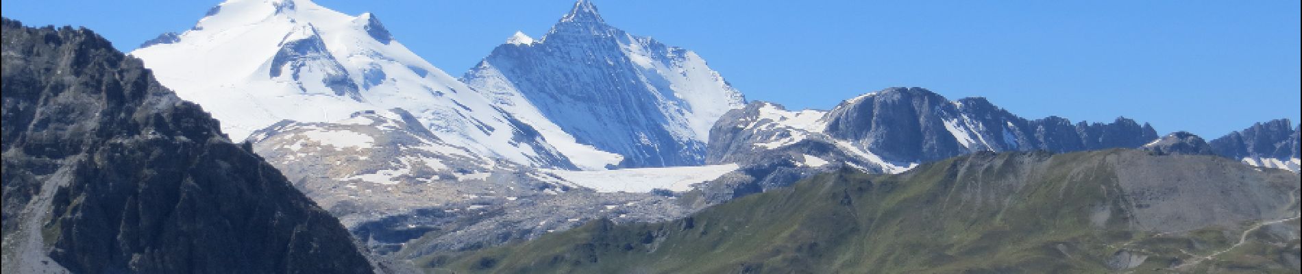
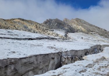
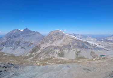
une randonnée au départ de la daille ou l'on empreinte un sentier assez raide mais malgré tout assez bon jusqu'au passage de Picheru; un peu avant ce dernier, aux alentours 2760m , prendre le sentier qui part au nord est en direction de la pointe, en haut du talus se diriger nord nord est vers un couloir dont il faut emprunter le côté droit pour rejoindre au dessus la pente herbeuse qui vous amènera au sommet; malheureusement pour moi j'ai du rebrousser chemin au milieu du couloir à 70 m sous le sommet, le temps imparti par mon épouse étant plus que largement consommé et m'a valu une descente en quatrième vitesse pas très agréable pour les jambes. ce n'est que partie remise pour l'année prochaine mais cette fois ce sera au départ du barrage du saut (moins de dénivelée)
Localisation
Commentaires
Randonnées à proximité
![Randonnée Marche Val-d'Isère - rocher du Charvet - Photo](https://media.geolcdn.com/t/375/260/695e5e9f-e8dc-4cf9-b576-ab38f18a42af.jpg&format=jpg&maxdim=2)
![Marche Marche](https://static1.geolcdn.com/sitytour/trail-icons/101.png)
Marche
![](/images/other/stat-length.png)
![](https://static1.geolcdn.com/siteimages/upload/files/16400158638029165_repeat_loop_refresh_sync_direction_icon.png)
![Randonnée Marche Tignes - la pointe de Picheru - Photo](https://media.geolcdn.com/t/375/260/ext.jpg?maxdim=2&url=https%3A%2F%2Fservices.sitytrail.com%2FGeolivesWS%2FDownloadMedia.ashx%3FTrailID%3D813856%26Media%3Dfix__20170820100255.jpg)
![Marche Marche](https://static1.geolcdn.com/sitytour/trail-icons/101.png)
Marche
![](/images/other/stat-length.png)
![](https://static1.geolcdn.com/siteimages/upload/files/16400158638029165_repeat_loop_refresh_sync_direction_icon.png)
![Randonnée Marche Tignes - lacs du saut et de la sassiere - Photo](https://media.geolcdn.com/t/375/260/ext.jpg?maxdim=2&url=https%3A%2F%2Fservices.sitytrail.com%2FGeolivesWS%2FDownloadMedia.ashx%3FTrailID%3D336967%26Media%3D637041f5-cff1-4406-a972-10b75ef104dd.JPG)
![Marche Marche](https://static1.geolcdn.com/sitytour/trail-icons/101.png)
Marche
![](/images/other/stat-length.png)
![](https://static1.geolcdn.com/siteimages/upload/files/16400158638029165_repeat_loop_refresh_sync_direction_icon.png)
![Randonnée Marche Tignes - Tignes 1800 lac de la Sassièrre aller-retour - Photo](https://media.geolcdn.com/t/375/260/ae37ca96-9517-4fd4-82f6-2f8c10f3622c.jpg&format=jpg&maxdim=2)
![Marche Marche](https://static1.geolcdn.com/sitytour/trail-icons/101.png)
Marche
![](/images/other/stat-length.png)
![](https://static1.geolcdn.com/siteimages/upload/files/16400158638029165_repeat_loop_refresh_sync_direction_icon.png)
![Randonnée Marche Tignes - boucle Tignes le lac - la daille - Photo](https://media.geolcdn.com/t/375/260/ext.jpg?maxdim=2&url=https%3A%2F%2Fservices.sitytrail.com%2FGeolivesWS%2FDownloadMedia.ashx%3FTrailID%3D132978%26Media%3D20120609144529.jpg)
![Marche Marche](https://static1.geolcdn.com/sitytour/trail-icons/101.png)
Marche
![](/images/other/stat-length.png)
![](https://static1.geolcdn.com/siteimages/upload/files/16400158638029165_repeat_loop_refresh_sync_direction_icon.png)
![Randonnée Marche Val-d'Isère - Les cascades des salins au départ de val d’Isère - Photo](https://media.geolcdn.com/t/375/260/c3b76218-f72c-4eeb-8155-41f32eab8f13.jpg&format=jpg&maxdim=2)
![Marche Marche](https://static1.geolcdn.com/sitytour/trail-icons/101.png)
Marche
![](/images/other/stat-length.png)
![](https://static1.geolcdn.com/siteimages/upload/files/16400158638029165_repeat_loop_refresh_sync_direction_icon.png)
![Randonnée Marche Tignes - Refuge de la Martin - Photo](https://media.geolcdn.com/t/375/260/ext.jpg?maxdim=2&url=https%3A%2F%2Fservices.sitytrail.com%2FGeolivesWS%2FDownloadMedia.ashx%3FTrailID%3D853550%26Media%3Dfix__20171025152818.jpg)
![Marche Marche](https://static1.geolcdn.com/sitytour/trail-icons/101.png)
Marche
![](/images/other/stat-length.png)
![](https://static1.geolcdn.com/siteimages/upload/files/16400158638029165_repeat_loop_refresh_sync_direction_icon.png)
![Randonnée Marche Tignes - approche glacière de la cime de la Golette - Photo](https://media.geolcdn.com/t/375/260/72e50cb0-5647-449b-b1a2-a84fe5e68f8a.jpg&format=jpg&maxdim=2)
![Marche Marche](https://static1.geolcdn.com/sitytour/trail-icons/101.png)
Marche
![](/images/other/stat-length.png)
![](https://static1.geolcdn.com/siteimages/upload/files/16400158638029165_repeat_loop_refresh_sync_direction_icon.png)
![Randonnée Marche Val-d'Isère - pointe de la Sana - Photo](https://media.geolcdn.com/t/375/260/cf1c2ddd-8e22-4533-8c04-6fcf89140ded.jpg&format=jpg&maxdim=2)
![Marche Marche](https://static1.geolcdn.com/sitytour/trail-icons/101.png)
Marche
![](/images/other/stat-length.png)
![](https://static1.geolcdn.com/siteimages/upload/files/16400158638029165_repeat_loop_refresh_sync_direction_icon.png)