![](/images/other/stat-length.png)
![Randonnée Autre activité Grindelwald - Faulhorn en luge - Photo](https://media.geolcdn.com/t/1900/400/ext.pjpeg?maxdim=2&url=https%3A%2F%2Fstatic1.geolcdn.com%2Fsiteimages%2Fupload%2Ffiles%2F1545311037marcheuse_200dpi.jpg)
Faulhorn en luge
Dgubler
Utilisateur
![Longueur](/images/other/stat-length.png)
![Altitude max](https://static1.geolcdn.com/siteimages/upload/files/1508320355ic_sort_altitude_max_24dp.png)
![Dénivelé positif](https://static1.geolcdn.com/siteimages/upload/files/1508320355ic_sort_den_pos_24dp.png)
![Km-Effort](/images/other/stat-length.png)
![Altitude min](https://static1.geolcdn.com/siteimages/upload/files/1508320355ic_sort_altitude_min_24dp.png)
![Dénivelé négatif](https://static1.geolcdn.com/siteimages/upload/files/1508320355ic_sort_den_neg_24dp.png)
![Boucle](https://static1.geolcdn.com/siteimages/upload/files/16400158638029165_repeat_loop_refresh_sync_direction_icon.png)
![Autre activité](https://static1.geolcdn.com/sitytour/trail-icons/900.png)
--
Difficulté : Inconnu
![Scannez ce code QR pour ouvrir la randonnée dans l'application SityTrail](https://capi.geolives.com/qq0zvz2zws4bq2lad0pu/sitytour/trails/33601/qr.png?size=200)
Application GPS de randonnée GRATUITE
À propos
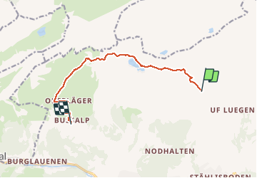
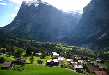
Randonnée Autre activité de 10 km à découvrir à Berne, Arrondissement administratif d'Interlaken-Oberhasli, Grindelwald. Cette randonnée est proposée par Dgubler.
Description
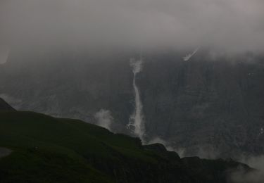
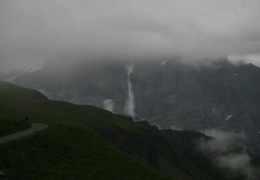
D''après l''office du tourisme de la région Junfrau, il s''agit de la plus longue randonnée en luge du monde (15 km). Nous en présentons ici 10 km (5 de montée, 5 de descente), entre First et Bussalp (le reste de la descente aurait été de la "papette").
En dénivellé: 350 m de montée, 750 m de descente.
Localisation
Commentaires
Randonnées à proximité
![Randonnée A pied Grindelwald - CH-Abzweigung Gleckstein - Glecksteinhütte - Photo](https://media.geolcdn.com/t/375/260/ef190951-62eb-4dbd-a99b-3b81e2e5a8e3.jpeg&format=jpg&maxdim=2)
![A pied A pied](https://static1.geolcdn.com/sitytour/trail-icons/100.png)
A pied
![](/images/other/stat-length.png)
![](https://static1.geolcdn.com/siteimages/upload/files/16400158638029165_repeat_loop_refresh_sync_direction_icon.png)
![Randonnée A pied Grindelwald - CH-Unterlauchbühl - Bort - Photo](https://media.geolcdn.com/t/375/260/917b7bc8-fc63-4bb4-ac37-b5bc1f4152ab.jpeg&format=jpg&maxdim=2)
![A pied A pied](https://static1.geolcdn.com/sitytour/trail-icons/100.png)
A pied
![](/images/other/stat-length.png)
![](https://static1.geolcdn.com/siteimages/upload/files/16400158638029165_repeat_loop_refresh_sync_direction_icon.png)
![Randonnée A pied Grindelwald - First - Bachalpsee - Fauhlhorn - Schynige Platte - Photo](https://media.geolcdn.com/t/375/260/b61592a8-cb23-41ac-904f-7c76e10b8fcc.jpeg&format=jpg&maxdim=2)
![A pied A pied](https://static1.geolcdn.com/sitytour/trail-icons/100.png)
A pied
![](/images/other/stat-length.png)
![](https://static1.geolcdn.com/siteimages/upload/files/16400158638029165_repeat_loop_refresh_sync_direction_icon.png)
![Randonnée A pied Grindelwald - Bachalpsee - Oberläger - Faulhorn - Photo](https://media.geolcdn.com/t/375/260/f62b1a84-1970-4e32-afcd-65dd14db1ded.jpeg&format=jpg&maxdim=2)
![A pied A pied](https://static1.geolcdn.com/sitytour/trail-icons/100.png)
A pied
![](/images/other/stat-length.png)
![](https://static1.geolcdn.com/siteimages/upload/files/16400158638029165_repeat_loop_refresh_sync_direction_icon.png)
![Randonnée A pied Grindelwald - Holewang - fixme - Photo](https://media.geolcdn.com/t/375/260/c1fd772a-1ad4-4009-8d2b-3788115972fd.jpeg&format=jpg&maxdim=2)
![A pied A pied](https://static1.geolcdn.com/sitytour/trail-icons/100.png)
A pied
![](/images/other/stat-length.png)
![](https://static1.geolcdn.com/siteimages/upload/files/16400158638029165_repeat_loop_refresh_sync_direction_icon.png)
![Randonnée A pied Grindelwald - Scheidegg / Oberläger - Wildgärst - Photo](https://media.geolcdn.com/t/375/260/4689ea70-6843-4964-b7a9-fdd50bcac679.jpeg&format=jpg&maxdim=2)
![A pied A pied](https://static1.geolcdn.com/sitytour/trail-icons/100.png)
A pied
![](/images/other/stat-length.png)
![](https://static1.geolcdn.com/siteimages/upload/files/16400158638029165_repeat_loop_refresh_sync_direction_icon.png)
![Randonnée A pied Grindelwald - Grosse Scheidegg - Scheidegg / Oberläger - Photo](https://media.geolcdn.com/t/375/260/96ca2c08-6940-4c3a-a732-f8b809054a0a.jpeg&format=jpg&maxdim=2)
![A pied A pied](https://static1.geolcdn.com/sitytour/trail-icons/100.png)
A pied
![](/images/other/stat-length.png)
![](https://static1.geolcdn.com/siteimages/upload/files/16400158638029165_repeat_loop_refresh_sync_direction_icon.png)
![Randonnée A pied Grindelwald - Grosse Scheidegg - Schreckfeld - Photo](https://media.geolcdn.com/t/375/260/96ca2c08-6940-4c3a-a732-f8b809054a0a.jpeg&format=jpg&maxdim=2)
![A pied A pied](https://static1.geolcdn.com/sitytour/trail-icons/100.png)
A pied
![](/images/other/stat-length.png)
![](https://static1.geolcdn.com/siteimages/upload/files/16400158638029165_repeat_loop_refresh_sync_direction_icon.png)
![Randonnée A pied Grindelwald - First - Grosse Scheidegg (Höhenweg 2400) - Photo](https://media.geolcdn.com/t/375/260/96ca2c08-6940-4c3a-a732-f8b809054a0a.jpeg&format=jpg&maxdim=2)
![A pied A pied](https://static1.geolcdn.com/sitytour/trail-icons/100.png)
A pied
![](/images/other/stat-length.png)
![](https://static1.geolcdn.com/siteimages/upload/files/16400158638029165_repeat_loop_refresh_sync_direction_icon.png)