![](/images/other/stat-length.png)
![Randonnée Marche Raeren - Petergensfeld (Balade de rêve 21) - Photo](https://media.geolcdn.com/t/1900/400/ext.pjpeg?maxdim=2&url=https%3A%2F%2Fstatic1.geolcdn.com%2Fsiteimages%2Fupload%2Ffiles%2F1553511878bg_sport_marche.png)
Petergensfeld (Balade de rêve 21)
mumu.larandonneuse
Utilisateur GUIDE
![Longueur](/images/other/stat-length.png)
![Altitude max](https://static1.geolcdn.com/siteimages/upload/files/1508320355ic_sort_altitude_max_24dp.png)
![Dénivelé positif](https://static1.geolcdn.com/siteimages/upload/files/1508320355ic_sort_den_pos_24dp.png)
![Km-Effort](/images/other/stat-length.png)
![Altitude min](https://static1.geolcdn.com/siteimages/upload/files/1508320355ic_sort_altitude_min_24dp.png)
![Dénivelé négatif](https://static1.geolcdn.com/siteimages/upload/files/1508320355ic_sort_den_neg_24dp.png)
![Boucle](https://static1.geolcdn.com/siteimages/upload/files/16400158638029165_repeat_loop_refresh_sync_direction_icon.png)
![Marche](https://static1.geolcdn.com/sitytour/trail-icons/101.png)
3h42
Difficulté : Moyen
![Scannez ce code QR pour ouvrir la randonnée dans l'application SityTrail](https://capi.geolives.com/qq0zvz2zws4bq2lad0pu/sitytour/trails/3359990/qr.png?size=200)
Application GPS de randonnée GRATUITE
À propos
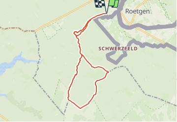
Randonnée Marche de 13,9 km à découvrir à Wallonie, Liège, Raeren. Cette randonnée est proposée par mumu.larandonneuse.
Description
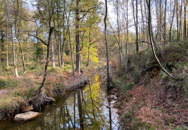
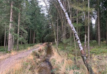
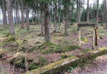
Le Reinartzhof, le Fagne de Kutenhart, l'Eschbach et la vallée de la Vesdre sont les points forts du parcours, bienvenue en terre sauvage !
Suivez les points-nœuds : 32 > 95 > 38 > 21 > 87 > 98 > 92 > 37 > 90 > 93 > 87 > 21 > 95 > 32
ℹ www.ostbelgien.eu ➡️ Balade n° 21
⚠️ 🐕 interdit
Localisation
Commentaires
Randonnées à proximité
![Randonnée Marche Raeren - Raeren - Photo](https://media.geolcdn.com/t/375/260/423c8447-b257-4538-8bf5-b82f7fde1439.jpg&format=jpg&maxdim=2)
![Marche Marche](https://static1.geolcdn.com/sitytour/trail-icons/101.png)
![Randonnée Marche Raeren - Petergensfeld - Natura 2000, des sites qui valent le détour - Lg21 - Photo](https://media.geolcdn.com/t/375/260/ext.jpg?maxdim=2&url=https%3A%2F%2Fservices.sitytrail.com%2FGeolivesWS%2FDownloadMedia.ashx%3FTrailID%3D612568%26Media%3D681f47ef-4b07-41b4-ba43-227c6775122c.JPG)
![Marche Marche](https://static1.geolcdn.com/sitytour/trail-icons/101.png)
Marche
![](/images/other/stat-length.png)
![](https://static1.geolcdn.com/siteimages/upload/files/16400158638029165_repeat_loop_refresh_sync_direction_icon.png)
![Randonnée Marche Raeren - Raeren Roetgen Eifelsteig 23 km - Photo](https://media.geolcdn.com/t/375/260/b745ae07-9105-45c9-80e8-b03ad5d85aa5.jpg&format=jpg&maxdim=2)
![Marche Marche](https://static1.geolcdn.com/sitytour/trail-icons/101.png)
Marche
![](/images/other/stat-length.png)
![](https://static1.geolcdn.com/siteimages/upload/files/16400158638029165_repeat_loop_refresh_sync_direction_icon.png)
![Randonnée A pied Roetgen - Hahner Straße Rundweg A2 - Photo](https://media.geolcdn.com/t/375/260/e319a090-49eb-475c-8cdf-c884ac2bc115.jpeg&format=jpg&maxdim=2)
![A pied A pied](https://static1.geolcdn.com/sitytour/trail-icons/100.png)
A pied
![](/images/other/stat-length.png)
![](https://static1.geolcdn.com/siteimages/upload/files/16400158638029165_repeat_loop_refresh_sync_direction_icon.png)
![Randonnée A pied Roetgen - Kall-Rur-Panorama-Route - Photo](https://media.geolcdn.com/t/375/260/79cfdf58-b035-4b32-b417-7c994ebf268e.jpeg&format=jpg&maxdim=2)
![A pied A pied](https://static1.geolcdn.com/sitytour/trail-icons/100.png)
A pied
![](/images/other/stat-length.png)
![](https://static1.geolcdn.com/siteimages/upload/files/16400158638029165_repeat_loop_refresh_sync_direction_icon.png)
![Randonnée A pied Roetgen - Rott Rundweg A3 - Photo](https://media.geolcdn.com/t/375/260/68d54c01-37fc-4225-b77f-3c3692b6e11c.jpeg&format=jpg&maxdim=2)
![A pied A pied](https://static1.geolcdn.com/sitytour/trail-icons/100.png)
A pied
![](/images/other/stat-length.png)
![](https://static1.geolcdn.com/siteimages/upload/files/16400158638029165_repeat_loop_refresh_sync_direction_icon.png)
![Randonnée A pied Roetgen - Struffelt-Route (Eifel) - Photo](https://media.geolcdn.com/t/375/260/e319a090-49eb-475c-8cdf-c884ac2bc115.jpeg&format=jpg&maxdim=2)
![A pied A pied](https://static1.geolcdn.com/sitytour/trail-icons/100.png)
A pied
![](/images/other/stat-length.png)
![](https://static1.geolcdn.com/siteimages/upload/files/16400158638029165_repeat_loop_refresh_sync_direction_icon.png)
![Randonnée A pied Raeren - Raerener Wald - Photo](https://media.geolcdn.com/t/375/260/6b60186b-6371-474b-8728-a21215d838fc.jpeg&format=jpg&maxdim=2)
![A pied A pied](https://static1.geolcdn.com/sitytour/trail-icons/100.png)
![Randonnée A pied Roetgen - Dorfrundgang Roetgen - Photo](https://media.geolcdn.com/t/375/260/6f9b91f1-4d12-490b-8774-c1691acc9755.jpeg&format=jpg&maxdim=2)
![A pied A pied](https://static1.geolcdn.com/sitytour/trail-icons/100.png)
A pied
![](/images/other/stat-length.png)
![](https://static1.geolcdn.com/siteimages/upload/files/16400158638029165_repeat_loop_refresh_sync_direction_icon.png)
Magnifique, 100% nature. 💚 Coup de cœur. ‼️Au points-noeud 87, juste après le pont, après 20 m., il manque le balisage de rappel vers 98 pour tourner à droite et emprunter le petit sentier le long du ruisseau.