![](/images/other/stat-length.png)
![Randonnée Marche Lorrez-le-Bocage-Préaux - Lorrez SR 090523 - Photo](https://media.geolcdn.com/t/1900/400/ext.pjpeg?maxdim=2&url=https%3A%2F%2Fstatic1.geolcdn.com%2Fsiteimages%2Fupload%2Ffiles%2F1553511878bg_sport_marche.png)
Lorrez SR 090523
fmg
Utilisateur
![Longueur](/images/other/stat-length.png)
Longueur
22 km
![Altitude max](https://static1.geolcdn.com/siteimages/upload/files/1508320355ic_sort_altitude_max_24dp.png)
Altitude max
151 m
![Dénivelé positif](https://static1.geolcdn.com/siteimages/upload/files/1508320355ic_sort_den_pos_24dp.png)
Dénivelé positif
220 m
![Km-Effort](/images/other/stat-length.png)
Km-Effort
25 km
![Altitude min](https://static1.geolcdn.com/siteimages/upload/files/1508320355ic_sort_altitude_min_24dp.png)
Altitude min
96 m
![Dénivelé négatif](https://static1.geolcdn.com/siteimages/upload/files/1508320355ic_sort_den_neg_24dp.png)
Dénivelé négatif
217 m
![Boucle](https://static1.geolcdn.com/siteimages/upload/files/16400158638029165_repeat_loop_refresh_sync_direction_icon.png)
Boucle
Oui
Date de création :
2022-08-15 13:48:27.632
Dernière modification :
2023-05-10 06:56:22.876
![Marche](https://static1.geolcdn.com/sitytour/trail-icons/101.png)
5h41
Difficulté : Très difficile
![Scannez ce code QR pour ouvrir la randonnée dans l'application SityTrail](https://capi.geolives.com/qq0zvz2zws4bq2lad0pu/sitytour/trails/3355549/qr.png?size=200)
Application GPS de randonnée GRATUITE
À propos
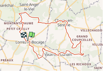
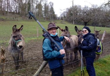
Randonnée Marche de 22 km à découvrir à Île-de-France, Seine-et-Marne, Lorrez-le-Bocage-Préaux. Cette randonnée est proposée par fmg.
Description
Selon l'état de la végétation (hautes herbes, cultures), certains chemins/bords de champs risquent de ne pas être praticables.
Il suffit alors d'improviser un peu et contourner.
Localisation
Pays :
France
Région :
Île-de-France
Département/Province :
Seine-et-Marne
Commune :
Lorrez-le-Bocage-Préaux
Localité :
Unknown
Départ:(Dec)
Départ:(UTM)
492615 ; 5342823 (31U) N.
Commentaires
Randonnées à proximité
![Randonnée A pied Paley - Le](https://media.geolcdn.com/t/375/260/c816f8c5-1b7e-467a-b427-7ddd8748fec3.jpeg&format=jpg&maxdim=2)
![A pied A pied](https://static1.geolcdn.com/sitytour/trail-icons/100.png)
Le "père" Trembleau
A pied
Facile
Paley,
Île-de-France,
Seine-et-Marne,
France
![](/images/other/stat-length.png)
15,8 km | 17,9 km-effort
4h 3min
![](https://static1.geolcdn.com/siteimages/upload/files/16400158638029165_repeat_loop_refresh_sync_direction_icon.png)
Oui
![Randonnée Marche Lorrez-le-Bocage-Préaux - Le Lunain et ses moulins - Photo](https://media.geolcdn.com/t/375/260/ext.jpg?maxdim=2&url=https%3A%2F%2Fservices.sitytrail.com%2FGeolivesWS%2FDownloadMedia.ashx%3FTrailID%3D101520%26Media%3D1622_5.jpg)
![Marche Marche](https://static1.geolcdn.com/sitytour/trail-icons/101.png)
Le Lunain et ses moulins
Marche
Difficile
(1)
Lorrez-le-Bocage-Préaux,
Île-de-France,
Seine-et-Marne,
France
![](/images/other/stat-length.png)
16,3 km | 19 km-effort
4h 0min
![](https://static1.geolcdn.com/siteimages/upload/files/16400158638029165_repeat_loop_refresh_sync_direction_icon.png)
Oui
![Randonnée Vélo de route Villebéon - EXT75 Villebéon-01 - Photo](https://media.geolcdn.com/t/375/260/ext.jpg?maxdim=2&url=https%3A%2F%2Fstatic1.geolcdn.com%2Fsiteimages%2Fupload%2Ffiles%2F1524743154velo.jpg)
![Vélo de route Vélo de route](https://static1.geolcdn.com/sitytour/trail-icons/201.png)
EXT75 Villebéon-01
Vélo de route
Très facile
Villebéon,
Île-de-France,
Seine-et-Marne,
France
![](/images/other/stat-length.png)
74 km | 83 km-effort
Inconnu
![](https://static1.geolcdn.com/siteimages/upload/files/16400158638029165_repeat_loop_refresh_sync_direction_icon.png)
Oui
![Randonnée V.T.T. Vaux-sur-Lunain - La vallée du Lunain - Photo](https://media.geolcdn.com/t/375/260/b6067454-149c-457c-9fe8-8d4542708754.jpg&format=jpg&maxdim=2)
![V.T.T. V.T.T.](https://static1.geolcdn.com/sitytour/trail-icons/202.png)
La vallée du Lunain
V.T.T.
Très facile
Vaux-sur-Lunain,
Île-de-France,
Seine-et-Marne,
France
![](/images/other/stat-length.png)
31 km | 35 km-effort
3h 21min
![](https://static1.geolcdn.com/siteimages/upload/files/16400158638029165_repeat_loop_refresh_sync_direction_icon.png)
Oui
![Randonnée sport Paley - Rando Dominique - Photo](https://media.geolcdn.com/t/375/260/ext.jpg?maxdim=2&url=https%3A%2F%2Fsecurestorage.geolives.com%2Fsitytour%2Ftrail-bg%2Fdefault.jpg)
Rando Dominique
sport
Très facile
Paley,
Île-de-France,
Seine-et-Marne,
France
![](/images/other/stat-length.png)
10,9 km | 12,5 km-effort
Inconnu
![](https://static1.geolcdn.com/siteimages/upload/files/16400158638029165_repeat_loop_refresh_sync_direction_icon.png)
Non
![Randonnée Marche Paley - Paley - Photo](https://media.geolcdn.com/t/375/260/2649a49e-4570-4acb-b4d0-1f4d13254a9b.jpg&format=jpg&maxdim=2)
![Marche Marche](https://static1.geolcdn.com/sitytour/trail-icons/101.png)
Paley
Marche
Très facile
Paley,
Île-de-France,
Seine-et-Marne,
France
![](/images/other/stat-length.png)
17,3 km | 21 km-effort
3h 55min
![](https://static1.geolcdn.com/siteimages/upload/files/16400158638029165_repeat_loop_refresh_sync_direction_icon.png)
Oui
![Randonnée Autre activité Villemaréchal - PREPA Potauteu 181208 M&R - Photo](https://media.geolcdn.com/t/375/260/ext.jpg?maxdim=2&url=https%3A%2F%2Fstatic1.geolcdn.com%2Fsiteimages%2Fupload%2Ffiles%2F1545311037marcheuse_200dpi.jpg)
![Autre activité Autre activité](https://static1.geolcdn.com/sitytour/trail-icons/900.png)
PREPA Potauteu 181208 M&R
Autre activité
Très facile
Villemaréchal,
Île-de-France,
Seine-et-Marne,
France
![](/images/other/stat-length.png)
22 km | 26 km-effort
10min
![](https://static1.geolcdn.com/siteimages/upload/files/16400158638029165_repeat_loop_refresh_sync_direction_icon.png)
Oui
![Randonnée Marche Paley - lunain historique - Photo](https://media.geolcdn.com/t/375/260/ext.jpg?maxdim=2&url=https%3A%2F%2Fstatic1.geolcdn.com%2Fsiteimages%2Fupload%2Ffiles%2F1553511878bg_sport_marche.png)
![Marche Marche](https://static1.geolcdn.com/sitytour/trail-icons/101.png)
lunain historique
Marche
Facile
Paley,
Île-de-France,
Seine-et-Marne,
France
![](/images/other/stat-length.png)
16 km | 18,9 km-effort
4h 10min
![](https://static1.geolcdn.com/siteimages/upload/files/16400158638029165_repeat_loop_refresh_sync_direction_icon.png)
Oui
![Randonnée Marche Lorrez-le-Bocage-Préaux - SVG 160909 - Photo](https://media.geolcdn.com/t/375/260/ext.jpg?maxdim=2&url=https%3A%2F%2Fstatic1.geolcdn.com%2Fsiteimages%2Fupload%2Ffiles%2F1553511878bg_sport_marche.png)
![Marche Marche](https://static1.geolcdn.com/sitytour/trail-icons/101.png)
SVG 160909
Marche
Très facile
Lorrez-le-Bocage-Préaux,
Île-de-France,
Seine-et-Marne,
France
![](/images/other/stat-length.png)
18,5 km | 21 km-effort
6h 28min
![](https://static1.geolcdn.com/siteimages/upload/files/16400158638029165_repeat_loop_refresh_sync_direction_icon.png)
Oui