![](/images/other/stat-length.png)
![Randonnée Malmedy - 2022-08-11_08h55m52_Cirkwi-Malmedy_15_-_Panorama_des_2_vallées - Photo](https://media.geolcdn.com/t/1900/400/ext.pjpeg?maxdim=2&url=https%3A%2F%2Fsecurestorage.geolives.com%2Fsitytour%2Ftrail-bg%2Fdefault.jpg)
2022-08-11_08h55m52_Cirkwi-Malmedy_15_-_Panorama_des_2_vallées
Maca8284
Utilisateur
![Longueur](/images/other/stat-length.png)
Longueur
10,5 km
![Altitude max](https://static1.geolcdn.com/siteimages/upload/files/1508320355ic_sort_altitude_max_24dp.png)
Altitude max
457 m
![Dénivelé positif](https://static1.geolcdn.com/siteimages/upload/files/1508320355ic_sort_den_pos_24dp.png)
Dénivelé positif
222 m
![Km-Effort](/images/other/stat-length.png)
Km-Effort
13,4 km
![Altitude min](https://static1.geolcdn.com/siteimages/upload/files/1508320355ic_sort_altitude_min_24dp.png)
Altitude min
341 m
![Dénivelé négatif](https://static1.geolcdn.com/siteimages/upload/files/1508320355ic_sort_den_neg_24dp.png)
Dénivelé négatif
222 m
![Boucle](https://static1.geolcdn.com/siteimages/upload/files/16400158638029165_repeat_loop_refresh_sync_direction_icon.png)
Boucle
Oui
Date de création :
2022-08-11 06:55:53.018
Dernière modification :
2022-08-11 06:55:55.279
![Scannez ce code QR pour ouvrir la randonnée dans l'application SityTrail](https://capi.geolives.com/qq0zvz2zws4bq2lad0pu/sitytour/trails/3350359/qr.png?size=200)
Application GPS de randonnée GRATUITE
À propos
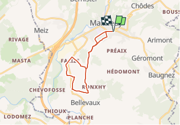
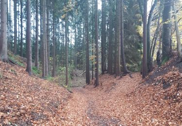
Randonnée de 10,5 km à découvrir à Wallonie, Liège, Malmedy. Cette randonnée est proposée par Maca8284.
Description
Depuis le RAVeL à Malmedy, montée vers le village de Xhurdebise où vous découvrirez un beau panorama, puis descente vers le rocher de Falize (à ne pas manquer) et retour vers Malmedy
Localisation
Pays :
Belgique
Région :
Wallonie
Département/Province :
Liège
Commune :
Malmedy
Localité :
Unknown
Départ:(Dec)
Départ:(UTM)
289232 ; 5589830 (32U) N.
Commentaires
Randonnées à proximité
![Randonnée Marche Malmedy - Le trôs Maret - Photo](https://media.geolcdn.com/t/375/260/97b4be7b-87c1-46c9-b673-d6e164fd84f1.jpg&format=jpg&maxdim=2)
![Marche Marche](https://static1.geolcdn.com/sitytour/trail-icons/101.png)
Le trôs Maret
Marche
Moyen
(14)
Malmedy,
Wallonie,
Liège,
Belgique
![](/images/other/stat-length.png)
7,3 km | 10,1 km-effort
2h 11min
![](https://static1.geolcdn.com/siteimages/upload/files/16400158638029165_repeat_loop_refresh_sync_direction_icon.png)
Oui
![Randonnée Marche Malmedy - La petite vallée sauvage du Trôs Marets - Photo](https://media.geolcdn.com/t/375/260/ext.jpg?maxdim=2&url=https%3A%2F%2Fstatic1.geolcdn.com%2Fsiteimages%2Fupload%2Ffiles%2F1553511878bg_sport_marche.png)
![Marche Marche](https://static1.geolcdn.com/sitytour/trail-icons/101.png)
La petite vallée sauvage du Trôs Marets
Marche
Moyen
(8)
Malmedy,
Wallonie,
Liège,
Belgique
![](/images/other/stat-length.png)
9,1 km | 12 km-effort
2h 37min
![](https://static1.geolcdn.com/siteimages/upload/files/16400158638029165_repeat_loop_refresh_sync_direction_icon.png)
Oui
![Randonnée Marche Malmedy - Malmedy - Baugnez - Photo](https://media.geolcdn.com/t/375/260/a34fa6e8-977c-4cba-8883-b5a7429035f5.jpg&format=jpg&maxdim=2)
![Marche Marche](https://static1.geolcdn.com/sitytour/trail-icons/101.png)
Malmedy - Baugnez
Marche
Moyen
(1)
Malmedy,
Wallonie,
Liège,
Belgique
![](/images/other/stat-length.png)
14,8 km | 18,9 km-effort
3h 15min
![](https://static1.geolcdn.com/siteimages/upload/files/16400158638029165_repeat_loop_refresh_sync_direction_icon.png)
Oui
![Randonnée Marche Malmedy - Bévercé _1102 - Photo](https://media.geolcdn.com/t/375/260/f624bfad-0543-4f87-8b2e-a4874ba371b1.jpg&format=jpg&maxdim=2)
![Marche Marche](https://static1.geolcdn.com/sitytour/trail-icons/101.png)
Bévercé _1102
Marche
Moyen
(2)
Malmedy,
Wallonie,
Liège,
Belgique
![](/images/other/stat-length.png)
15,2 km | 21 km-effort
4h 41min
![](https://static1.geolcdn.com/siteimages/upload/files/16400158638029165_repeat_loop_refresh_sync_direction_icon.png)
Oui
![Randonnée Marche Malmedy - ferme libert tro maret - Photo](https://media.geolcdn.com/t/375/260/ext.jpg?maxdim=2&url=https%3A%2F%2Fservices.sitytrail.com%2FGeolivesWS%2FDownloadMedia.ashx%3FTrailID%3D202740%26Media%3D20130704170612.jpeg)
![Marche Marche](https://static1.geolcdn.com/sitytour/trail-icons/101.png)
ferme libert tro maret
Marche
Moyen
(1)
Malmedy,
Wallonie,
Liège,
Belgique
![](/images/other/stat-length.png)
5,5 km | 7,4 km-effort
1h 35min
![](https://static1.geolcdn.com/siteimages/upload/files/16400158638029165_repeat_loop_refresh_sync_direction_icon.png)
Oui
![Randonnée Marche Malmedy - RB-Lg-09_Bellevaux - Photo](https://media.geolcdn.com/t/375/260/ext.jpg?maxdim=2&url=https%3A%2F%2Fservices.sitytrail.com%2FGeolivesWS%2FDownloadMedia.ashx%3FTrailID%3D179567%26Media%3D798cfc5d-29e8-4b87-852c-cc68a99be049.jpg)
![Marche Marche](https://static1.geolcdn.com/sitytour/trail-icons/101.png)
RB-Lg-09_Bellevaux
Marche
Moyen
(4)
Malmedy,
Wallonie,
Liège,
Belgique
![](/images/other/stat-length.png)
26 km | 34 km-effort
7h 12min
![](https://static1.geolcdn.com/siteimages/upload/files/16400158638029165_repeat_loop_refresh_sync_direction_icon.png)
Oui
![Randonnée Marche Malmedy - Le canyon des Trôs-Marèts à Malmedy - Photo](https://media.geolcdn.com/t/375/260/00b47c34-b42a-48f8-a2cb-09ee85e4736c.jpg&format=jpg&maxdim=2)
![Marche Marche](https://static1.geolcdn.com/sitytour/trail-icons/101.png)
Le canyon des Trôs-Marèts à Malmedy
Marche
Moyen
(2)
Malmedy,
Wallonie,
Liège,
Belgique
![](/images/other/stat-length.png)
5 km | 6,8 km-effort
1h 32min
![](https://static1.geolcdn.com/siteimages/upload/files/16400158638029165_repeat_loop_refresh_sync_direction_icon.png)
Oui
![Randonnée Marche Malmedy - xhoffraix . cheneux . moulin et cascade bayehon . vieux chêne . longfaye . xhoffraix - Photo](https://media.geolcdn.com/t/375/260/d03e0c64-90c0-4767-998e-9e240f1eb32e.jpg&format=jpg&maxdim=2)
![Marche Marche](https://static1.geolcdn.com/sitytour/trail-icons/101.png)
xhoffraix . cheneux . moulin et cascade bayehon . vieux chêne . longfaye . xh...
Marche
Facile
(2)
Malmedy,
Wallonie,
Liège,
Belgique
![](/images/other/stat-length.png)
12,3 km | 15,9 km-effort
3h 7min
![](https://static1.geolcdn.com/siteimages/upload/files/16400158638029165_repeat_loop_refresh_sync_direction_icon.png)
Oui
![Randonnée Marche Malmedy - malmedy . ferme libert . tro maret . ferme libert . malmedy par les crêtes - Photo](https://media.geolcdn.com/t/375/260/6c222aa1-844a-4917-af45-0da05eb40a0e.jpg&format=jpg&maxdim=2)
![Marche Marche](https://static1.geolcdn.com/sitytour/trail-icons/101.png)
malmedy . ferme libert . tro maret . ferme libert . malmedy par les crêtes
Marche
Très facile
(1)
Malmedy,
Wallonie,
Liège,
Belgique
![](/images/other/stat-length.png)
13,1 km | 18,8 km-effort
4h 1min
![](https://static1.geolcdn.com/siteimages/upload/files/16400158638029165_repeat_loop_refresh_sync_direction_icon.png)
Oui