![](/images/other/stat-length.png)
![Randonnée Marche Saint-Trond - Le domaine 't Speelhof à Saint-Trond - Photo](https://media.geolcdn.com/t/1900/400/46e37628-5e32-4494-85b7-b69cb5ce1e50.jpeg&format=pjpeg&maxdim=2)
Le domaine 't Speelhof à Saint-Trond
Benjamin27
Utilisateur GUIDE
![Longueur](/images/other/stat-length.png)
![Altitude max](https://static1.geolcdn.com/siteimages/upload/files/1508320355ic_sort_altitude_max_24dp.png)
![Dénivelé positif](https://static1.geolcdn.com/siteimages/upload/files/1508320355ic_sort_den_pos_24dp.png)
![Km-Effort](/images/other/stat-length.png)
![Altitude min](https://static1.geolcdn.com/siteimages/upload/files/1508320355ic_sort_altitude_min_24dp.png)
![Dénivelé négatif](https://static1.geolcdn.com/siteimages/upload/files/1508320355ic_sort_den_neg_24dp.png)
![Boucle](https://static1.geolcdn.com/siteimages/upload/files/16400158638029165_repeat_loop_refresh_sync_direction_icon.png)
![Marche](https://static1.geolcdn.com/sitytour/trail-icons/101.png)
35m
Difficulté : Facile
![Scannez ce code QR pour ouvrir la randonnée dans l'application SityTrail](https://capi.geolives.com/qq0zvz2zws4bq2lad0pu/sitytour/trails/3350259/qr.png?size=200)
Application GPS de randonnée GRATUITE
À propos
Randonnée Marche de 2,4 km à découvrir à Flandre, Limbourg, Saint-Trond. Cette randonnée est proposée par Benjamin27.
Description
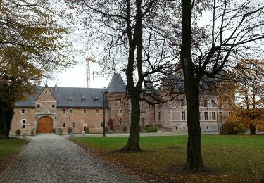
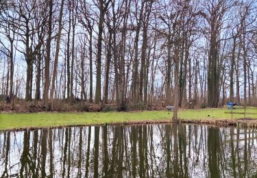
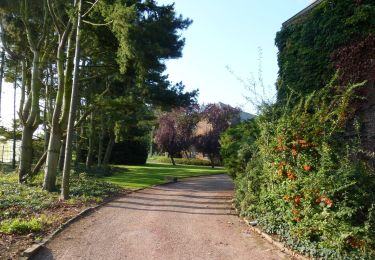
Très joli. Si vous voulez voir des animaux, un magnifique cours d’eau, des paysages de la Hesbaye et vous ressourcer au calme c’est par ici!
👣 Distance : 2,5km - balisage flèche rouge.
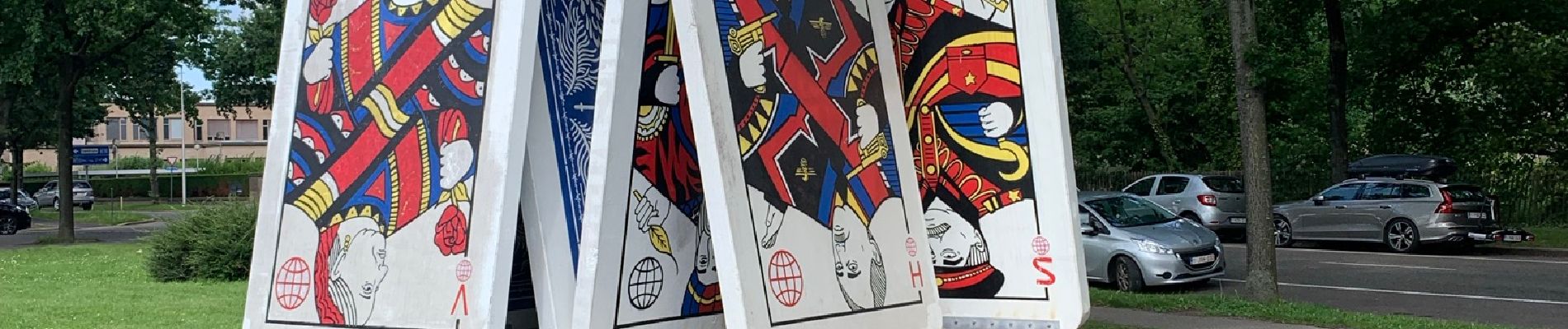
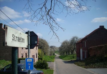
📍 Départ : parking sur Veemarkt/Speelhoflaan (l’entrée du domaine est de l’autre côté du passage pour piétons sur le trottoir en face des grandes cartes).
🚂🚍 Aller à la gare de Saint-Trond et prendre le bus DE LIJN S1 jusqu’à l’arrêt « Sint-Truiden Veemarkt ».
Localisation
Commentaires
Randonnées à proximité
![Randonnée Marche Saint-Trond - Aalst Dorp - Photo](https://media.geolcdn.com/t/375/260/ext.jpg?maxdim=2&url=https%3A%2F%2Fservices.sitytrail.com%2FGeolivesWS%2FDownloadMedia.ashx%3FTrailID%3D238221%26Media%3Dfix__20131125132034.jpg)
![Marche Marche](https://static1.geolcdn.com/sitytour/trail-icons/101.png)
Marche
![](/images/other/stat-length.png)
![](https://static1.geolcdn.com/siteimages/upload/files/16400158638029165_repeat_loop_refresh_sync_direction_icon.png)
![Randonnée Marche Saint-Trond - Promenade dans le domaine provincial](https://media.geolcdn.com/t/375/260/b90730e6-26e4-40d2-a400-559a79179cf5.jpg&format=jpg&maxdim=2)
![Marche Marche](https://static1.geolcdn.com/sitytour/trail-icons/101.png)
Marche
![](/images/other/stat-length.png)
![](https://static1.geolcdn.com/siteimages/upload/files/16400158638029165_repeat_loop_refresh_sync_direction_icon.png)
![Randonnée A pied Saint-Trond - Bernissem wandeling - Photo](https://media.geolcdn.com/t/375/260/da47f886-95ef-4a45-a44c-87cd8463dff7.jpeg&format=jpg&maxdim=2)
![A pied A pied](https://static1.geolcdn.com/sitytour/trail-icons/100.png)
A pied
![](/images/other/stat-length.png)
![](https://static1.geolcdn.com/siteimages/upload/files/16400158638029165_repeat_loop_refresh_sync_direction_icon.png)
![Randonnée A pied Saint-Trond - Cicindria Straeten oranje bol - Photo](https://media.geolcdn.com/t/375/260/6d7e87b3-3f7e-4b4a-bf60-733308598a38.jpeg&format=jpg&maxdim=2)
![A pied A pied](https://static1.geolcdn.com/sitytour/trail-icons/100.png)
A pied
![](/images/other/stat-length.png)
![](https://static1.geolcdn.com/siteimages/upload/files/16400158638029165_repeat_loop_refresh_sync_direction_icon.png)
![Randonnée A pied Saint-Trond - Cicindria Straeten groene rechthoek - Photo](https://media.geolcdn.com/t/375/260/6d7e87b3-3f7e-4b4a-bf60-733308598a38.jpeg&format=jpg&maxdim=2)
![A pied A pied](https://static1.geolcdn.com/sitytour/trail-icons/100.png)
A pied
![](/images/other/stat-length.png)
![](https://static1.geolcdn.com/siteimages/upload/files/16400158638029165_repeat_loop_refresh_sync_direction_icon.png)
![Randonnée A pied Saint-Trond - Staaien rode driehoek - Photo](https://media.geolcdn.com/t/375/260/cd3d1f60-3cd2-4539-a2b4-06ec7df817c9.jpeg&format=jpg&maxdim=2)
![A pied A pied](https://static1.geolcdn.com/sitytour/trail-icons/100.png)
A pied
![](/images/other/stat-length.png)
![](https://static1.geolcdn.com/siteimages/upload/files/16400158638029165_repeat_loop_refresh_sync_direction_icon.png)
![Randonnée A pied Saint-Trond - Staaien oranje bol - Photo](https://media.geolcdn.com/t/375/260/7b137b54-411c-4e68-8c6c-aeb3fad0dd86.jpeg&format=jpg&maxdim=2)
![A pied A pied](https://static1.geolcdn.com/sitytour/trail-icons/100.png)
A pied
![](/images/other/stat-length.png)
![](https://static1.geolcdn.com/siteimages/upload/files/16400158638029165_repeat_loop_refresh_sync_direction_icon.png)
![Randonnée A pied Saint-Trond - Nieuwenhoven Oranje bol - Photo](https://media.geolcdn.com/t/375/260/b2e64be1-e82e-4959-ae54-cebd0419e976.jpeg&format=jpg&maxdim=2)
![A pied A pied](https://static1.geolcdn.com/sitytour/trail-icons/100.png)
A pied
![](/images/other/stat-length.png)
![](https://static1.geolcdn.com/siteimages/upload/files/16400158638029165_repeat_loop_refresh_sync_direction_icon.png)
![Randonnée A pied Saint-Trond - Nieuwenhoven Blauwe ruit - Photo](https://media.geolcdn.com/t/375/260/b2e64be1-e82e-4959-ae54-cebd0419e976.jpeg&format=jpg&maxdim=2)
![A pied A pied](https://static1.geolcdn.com/sitytour/trail-icons/100.png)
A pied
![](/images/other/stat-length.png)
![](https://static1.geolcdn.com/siteimages/upload/files/16400158638029165_repeat_loop_refresh_sync_direction_icon.png)