![](/images/other/stat-length.png)
![Randonnée Marche Castans - d'Escandelle au poirier - Photo](https://media.geolcdn.com/t/1900/400/ext.pjpeg?maxdim=2&url=https%3A%2F%2Fstatic1.geolcdn.com%2Fsiteimages%2Fupload%2Ffiles%2F1553511878bg_sport_marche.png)
d'Escandelle au poirier
louisng
Utilisateur
![Longueur](/images/other/stat-length.png)
Longueur
4,6 km
![Altitude max](https://static1.geolcdn.com/siteimages/upload/files/1508320355ic_sort_altitude_max_24dp.png)
Altitude max
829 m
![Dénivelé positif](https://static1.geolcdn.com/siteimages/upload/files/1508320355ic_sort_den_pos_24dp.png)
Dénivelé positif
173 m
![Km-Effort](/images/other/stat-length.png)
Km-Effort
6,9 km
![Altitude min](https://static1.geolcdn.com/siteimages/upload/files/1508320355ic_sort_altitude_min_24dp.png)
Altitude min
643 m
![Dénivelé négatif](https://static1.geolcdn.com/siteimages/upload/files/1508320355ic_sort_den_neg_24dp.png)
Dénivelé négatif
178 m
![Boucle](https://static1.geolcdn.com/siteimages/upload/files/16400158638029165_repeat_loop_refresh_sync_direction_icon.png)
Boucle
Oui
Date de création :
2022-08-10 07:24:43.849
Dernière modification :
2022-08-10 09:15:10.3
![Marche](https://static1.geolcdn.com/sitytour/trail-icons/101.png)
1h48
Difficulté : Facile
![Scannez ce code QR pour ouvrir la randonnée dans l'application SityTrail](https://capi.geolives.com/qq0zvz2zws4bq2lad0pu/sitytour/trails/3349308/qr.png?size=200)
Application GPS de randonnée GRATUITE
À propos
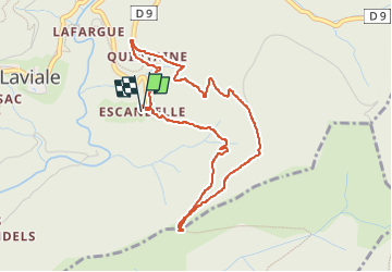
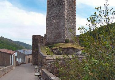
Randonnée Marche de 4,6 km à découvrir à Occitanie, Aude, Castans. Cette randonnée est proposée par louisng.
Description
Par le chemin de Paulette puis le chemin de la source pour suivre l'usqu'a l'ancien relais que l'on contourne jusqu'au poirier.
On peut revenir en suivant la piste vers l'est jusqu'au chemin qui revient à Escandelle par-là bergerie d'Adrien.
Localisation
Pays :
France
Région :
Occitanie
Département/Province :
Aude
Commune :
Castans
Localité :
Unknown
Départ:(Dec)
Départ:(UTM)
459023 ; 4805861 (31T) N.
Commentaires
Randonnées à proximité
![Randonnée Marche Castans - Boucle des ruisseaux - Castans - Photo](https://media.geolcdn.com/t/375/260/ext.jpg?maxdim=2&url=https%3A%2F%2Fservices.sitytrail.com%2FGeolivesWS%2FDownloadMedia.ashx%3FTrailID%3D107218%26Media%3D12083_6.jpg)
![Marche Marche](https://static1.geolcdn.com/sitytour/trail-icons/101.png)
Boucle des ruisseaux - Castans
Marche
Moyen
(5)
Castans,
Occitanie,
Aude,
France
![](/images/other/stat-length.png)
6,4 km | 10 km-effort
4h 0min
![](https://static1.geolcdn.com/siteimages/upload/files/16400158638029165_repeat_loop_refresh_sync_direction_icon.png)
Oui
![Randonnée A pied Cabrespine - Les Villages Perchés - Photo](https://media.geolcdn.com/t/375/260/4379f8e7-e0a2-4ee4-810f-0aa42c1f51f8.jpeg&format=jpg&maxdim=2)
![A pied A pied](https://static1.geolcdn.com/sitytour/trail-icons/100.png)
Les Villages Perchés
A pied
Facile
Cabrespine,
Occitanie,
Aude,
France
![](/images/other/stat-length.png)
8,3 km | 14,7 km-effort
3h 21min
![](https://static1.geolcdn.com/siteimages/upload/files/16400158638029165_repeat_loop_refresh_sync_direction_icon.png)
Non
![Randonnée A pied Pradelles-Cabardès - Les Villages Perchés - Photo](https://media.geolcdn.com/t/375/260/e752b52d-77fb-4704-ae95-b1e1dc6afb9d.jpeg&format=jpg&maxdim=2)
![A pied A pied](https://static1.geolcdn.com/sitytour/trail-icons/100.png)
Les Villages Perchés
A pied
Moyen
Pradelles-Cabardès,
Occitanie,
Aude,
France
![](/images/other/stat-length.png)
19,4 km | 29 km-effort
6h 34min
![](https://static1.geolcdn.com/siteimages/upload/files/16400158638029165_repeat_loop_refresh_sync_direction_icon.png)
Non
![Randonnée A pied Pradelles-Cabardès - Les Villages Perchés - Photo](https://media.geolcdn.com/t/375/260/db649366-1098-4fbe-adda-fceac6e0e268.jpeg&format=jpg&maxdim=2)
![A pied A pied](https://static1.geolcdn.com/sitytour/trail-icons/100.png)
Les Villages Perchés
A pied
Moyen
Pradelles-Cabardès,
Occitanie,
Aude,
France
![](/images/other/stat-length.png)
19,2 km | 26 km-effort
5h 53min
![](https://static1.geolcdn.com/siteimages/upload/files/16400158638029165_repeat_loop_refresh_sync_direction_icon.png)
Non
![Randonnée A pied Pradelles-Cabardès - Pradelles Cabardes . Le Pic de Nore, le sentier du Roc Nouret. - Photo](https://media.geolcdn.com/t/375/260/ext.jpg?maxdim=2&url=https%3A%2F%2Fstatic1.geolcdn.com%2Fsiteimages%2Fupload%2Ffiles%2F1545311037marcheuse_200dpi.jpg)
![A pied A pied](https://static1.geolcdn.com/sitytour/trail-icons/100.png)
Pradelles Cabardes . Le Pic de Nore, le sentier du Roc Nouret.
A pied
Facile
(1)
Pradelles-Cabardès,
Occitanie,
Aude,
France
![](/images/other/stat-length.png)
10,4 km | 16,4 km-effort
3h 44min
![](https://static1.geolcdn.com/siteimages/upload/files/16400158638029165_repeat_loop_refresh_sync_direction_icon.png)
Oui
![Randonnée A pied Pradelles-Cabardès - Pradelles,roc de l'aigle,cabrespine,pradelles - Photo](https://media.geolcdn.com/t/375/260/82fe34a8-bde4-49e0-8e94-332d7cbba6cc.jpg&format=jpg&maxdim=2)
![A pied A pied](https://static1.geolcdn.com/sitytour/trail-icons/100.png)
Pradelles,roc de l'aigle,cabrespine,pradelles
A pied
Difficile
Pradelles-Cabardès,
Occitanie,
Aude,
France
![](/images/other/stat-length.png)
15,3 km | 24 km-effort
5h 50min
![](https://static1.geolcdn.com/siteimages/upload/files/16400158638029165_repeat_loop_refresh_sync_direction_icon.png)
Oui
![Randonnée Marche Citou - Citou et sa château - Photo](https://media.geolcdn.com/t/375/260/ext.jpg?maxdim=2&url=https%3A%2F%2Fservices.sitytrail.com%2FGeolivesWS%2FDownloadMedia.ashx%3FTrailID%3D537529%26Media%3Dfix__20160313114332.jpg)
![Marche Marche](https://static1.geolcdn.com/sitytour/trail-icons/101.png)
![Randonnée Marche Cabrespine - Cabrespine - Condamine - Photo](https://media.geolcdn.com/t/375/260/ext.jpg?maxdim=2&url=https%3A%2F%2Fservices.sitytrail.com%2FGeolivesWS%2FDownloadMedia.ashx%3FTrailID%3D172379%26Media%3D13722_4.jpg)
![Marche Marche](https://static1.geolcdn.com/sitytour/trail-icons/101.png)
Cabrespine - Condamine
Marche
Moyen
Cabrespine,
Occitanie,
Aude,
France
![](/images/other/stat-length.png)
9,5 km | 14,8 km-effort
3h 0min
![](https://static1.geolcdn.com/siteimages/upload/files/16400158638029165_repeat_loop_refresh_sync_direction_icon.png)
Oui
![Randonnée Marche Lespinassière - Lespinassière - La Serre d'Alaric - Photo](https://media.geolcdn.com/t/375/260/ext.jpg?maxdim=2&url=https%3A%2F%2Fservices.sitytrail.com%2FGeolivesWS%2FDownloadMedia.ashx%3FTrailID%3D172270%26Media%3D13583_6.jpg)
![Marche Marche](https://static1.geolcdn.com/sitytour/trail-icons/101.png)
Lespinassière - La Serre d'Alaric
Marche
Moyen
Lespinassière,
Occitanie,
Aude,
France
![](/images/other/stat-length.png)
19,1 km | 29 km-effort
6h 30min
![](https://static1.geolcdn.com/siteimages/upload/files/16400158638029165_repeat_loop_refresh_sync_direction_icon.png)
Oui