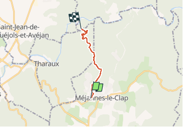
![](/images/other/stat-length.png)
![Randonnée Marche Méjannes-le-Clap - vvf jusqu'à grotte de la salamandre - Photo](https://media.geolcdn.com/t/1900/400/ext.pjpeg?maxdim=2&url=https%3A%2F%2Fstatic1.geolcdn.com%2Fsiteimages%2Fupload%2Ffiles%2F1553511878bg_sport_marche.png)
vvf jusqu'à grotte de la salamandre
Robertplessier
Utilisateur
![Longueur](/images/other/stat-length.png)
Longueur
5,8 km
![Altitude max](https://static1.geolcdn.com/siteimages/upload/files/1508320355ic_sort_altitude_max_24dp.png)
Altitude max
326 m
![Dénivelé positif](https://static1.geolcdn.com/siteimages/upload/files/1508320355ic_sort_den_pos_24dp.png)
Dénivelé positif
64 m
![Km-Effort](/images/other/stat-length.png)
Km-Effort
7,1 km
![Altitude min](https://static1.geolcdn.com/siteimages/upload/files/1508320355ic_sort_altitude_min_24dp.png)
Altitude min
171 m
![Dénivelé négatif](https://static1.geolcdn.com/siteimages/upload/files/1508320355ic_sort_den_neg_24dp.png)
Dénivelé négatif
202 m
![Boucle](https://static1.geolcdn.com/siteimages/upload/files/16400158638029165_repeat_loop_refresh_sync_direction_icon.png)
Boucle
Non
Date de création :
2022-08-09 13:40:15.775
Dernière modification :
2022-08-09 14:58:06.682
![Marche](https://static1.geolcdn.com/sitytour/trail-icons/101.png)
1h15
Difficulté : Difficile
![Scannez ce code QR pour ouvrir la randonnée dans l'application SityTrail](https://capi.geolives.com/qq0zvz2zws4bq2lad0pu/sitytour/trails/3348656/qr.png?size=200)
Application GPS de randonnée GRATUITE
À propos
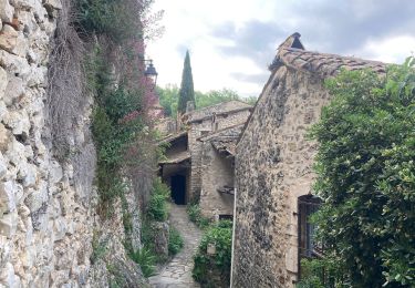
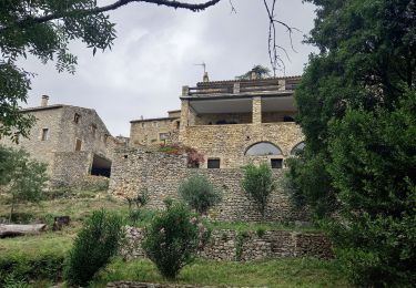
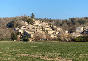
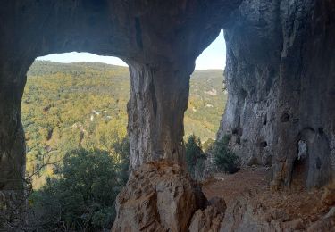
Randonnée Marche de 5,8 km à découvrir à Occitanie, Gard, Méjannes-le-Clap. Cette randonnée est proposée par Robertplessier.
Description
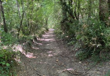
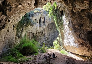
Chemin dans le lit rivière asséchée, peu entretenu et pratiqué, beaucoup de branches basses, ombre mais difficile
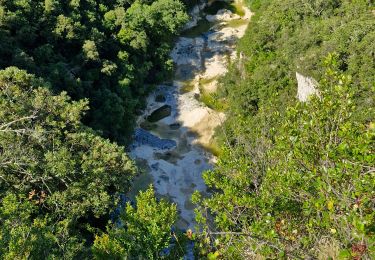
Déconseillé pour rejoindre la grotte
Localisation
Pays :
France
Région :
Occitanie
Département/Province :
Gard
Commune :
Méjannes-le-Clap
Localité :
Unknown
Départ:(Dec)
Départ:(UTM)
607184 ; 4897713 (31T) N.
Commentaires
Randonnées à proximité
![Randonnée Marche Lussan - Concluses de Lussan - Photo](https://media.geolcdn.com/t/375/260/c22ae11d-0c26-4c10-b347-194805291eb0.jpg&format=jpg&maxdim=2)
![Marche Marche](https://static1.geolcdn.com/sitytour/trail-icons/101.png)
Concluses de Lussan
Marche
Difficile
Lussan,
Occitanie,
Gard,
France
![](/images/other/stat-length.png)
26 km | 0 m-effort
5h 46min
![](https://static1.geolcdn.com/siteimages/upload/files/16400158638029165_repeat_loop_refresh_sync_direction_icon.png)
Non
![Randonnée Marche Tharaux - Tharaux - Photo](https://media.geolcdn.com/t/375/260/01bc6044-7c62-4cc1-8831-f55311bb9329.jpg&format=jpg&maxdim=2)
![Marche Marche](https://static1.geolcdn.com/sitytour/trail-icons/101.png)
![Randonnée Marche Lussan - Les Concluses de Lussan 15km. - Photo](https://media.geolcdn.com/t/375/260/41bacd99-3471-4adf-8f7c-5179b77b55cd.jpg&format=jpg&maxdim=2)
![Marche Marche](https://static1.geolcdn.com/sitytour/trail-icons/101.png)
Les Concluses de Lussan 15km.
Marche
Très difficile
Lussan,
Occitanie,
Gard,
France
![](/images/other/stat-length.png)
14,8 km | 20 km-effort
4h 34min
![](https://static1.geolcdn.com/siteimages/upload/files/16400158638029165_repeat_loop_refresh_sync_direction_icon.png)
Oui
![Randonnée Marche Rochegude - ROCHEGUDE - GROTTE DES CAMISARDS - Photo](https://media.geolcdn.com/t/375/260/16497b10-8ac8-49c4-9447-7778ef028cc3.jpeg&format=jpg&maxdim=2)
![Marche Marche](https://static1.geolcdn.com/sitytour/trail-icons/101.png)
ROCHEGUDE - GROTTE DES CAMISARDS
Marche
Moyen
Rochegude,
Occitanie,
Gard,
France
![](/images/other/stat-length.png)
5 km | 7,6 km-effort
1h 43min
![](https://static1.geolcdn.com/siteimages/upload/files/16400158638029165_repeat_loop_refresh_sync_direction_icon.png)
Oui
![Randonnée Marche Tharaux - Tharaux la Cèze - Photo](https://media.geolcdn.com/t/375/260/4bdb970c-b0f9-4e30-b3b2-4f135c4250be.jpg&format=jpg&maxdim=2)
![Marche Marche](https://static1.geolcdn.com/sitytour/trail-icons/101.png)
![Randonnée Marche Méjannes-le-Clap - mejannes le clap - Photo](https://media.geolcdn.com/t/375/260/d0e23ebe-33e3-4300-84fa-90d302ddb272.jpg&format=jpg&maxdim=2)
![Marche Marche](https://static1.geolcdn.com/sitytour/trail-icons/101.png)
mejannes le clap
Marche
Moyen
Méjannes-le-Clap,
Occitanie,
Gard,
France
![](/images/other/stat-length.png)
14,4 km | 19,3 km-effort
5h 19min
![](https://static1.geolcdn.com/siteimages/upload/files/16400158638029165_repeat_loop_refresh_sync_direction_icon.png)
Oui
![Randonnée Marche Rochegude - Rochegude 30 - Photo](https://media.geolcdn.com/t/375/260/a538ea29-ca1c-4e49-a5d0-6fa2d1fad284.jpg&format=jpg&maxdim=2)
![Marche Marche](https://static1.geolcdn.com/sitytour/trail-icons/101.png)
Rochegude 30
Marche
Difficile
Rochegude,
Occitanie,
Gard,
France
![](/images/other/stat-length.png)
15,6 km | 21 km-effort
5h 42min
![](https://static1.geolcdn.com/siteimages/upload/files/16400158638029165_repeat_loop_refresh_sync_direction_icon.png)
Oui
![Randonnée Marche Méjannes-le-Clap - Mejannes le clap par Rocher de l'Aigle - Photo](https://media.geolcdn.com/t/375/260/71c29605-58ee-4bb6-9602-558b471b1323.jpg&format=jpg&maxdim=2)
![Marche Marche](https://static1.geolcdn.com/sitytour/trail-icons/101.png)
Mejannes le clap par Rocher de l'Aigle
Marche
Difficile
Méjannes-le-Clap,
Occitanie,
Gard,
France
![](/images/other/stat-length.png)
15,3 km | 21 km-effort
5h 14min
![](https://static1.geolcdn.com/siteimages/upload/files/16400158638029165_repeat_loop_refresh_sync_direction_icon.png)
Oui
![Randonnée Marche Méjannes-le-Clap - grotte Aven de Peyre haute - Photo](https://media.geolcdn.com/t/375/260/d4f3ec17-14e0-4af7-b0c9-c2d485c47a84.jpg&format=jpg&maxdim=2)
![Marche Marche](https://static1.geolcdn.com/sitytour/trail-icons/101.png)
grotte Aven de Peyre haute
Marche
Très facile
(1)
Méjannes-le-Clap,
Occitanie,
Gard,
France
![](/images/other/stat-length.png)
3,6 km | 4,6 km-effort
1h 13min
![](https://static1.geolcdn.com/siteimages/upload/files/16400158638029165_repeat_loop_refresh_sync_direction_icon.png)
Oui