![](/images/other/stat-length.png)
![Randonnée Marche Dolcedo - Laghetti di Lecchiore - Photo](https://media.geolcdn.com/t/1900/400/e1762a2c-5d20-416c-9640-a12bff09ab98.jpg&format=pjpeg&maxdim=2)
Laghetti di Lecchiore
patjobou
Utilisateur
![Longueur](/images/other/stat-length.png)
![Altitude max](https://static1.geolcdn.com/siteimages/upload/files/1508320355ic_sort_altitude_max_24dp.png)
![Dénivelé positif](https://static1.geolcdn.com/siteimages/upload/files/1508320355ic_sort_den_pos_24dp.png)
![Km-Effort](/images/other/stat-length.png)
![Altitude min](https://static1.geolcdn.com/siteimages/upload/files/1508320355ic_sort_altitude_min_24dp.png)
![Dénivelé négatif](https://static1.geolcdn.com/siteimages/upload/files/1508320355ic_sort_den_neg_24dp.png)
![Boucle](https://static1.geolcdn.com/siteimages/upload/files/16400158638029165_repeat_loop_refresh_sync_direction_icon.png)
![Marche](https://static1.geolcdn.com/sitytour/trail-icons/101.png)
5h14
Difficulté : Facile
![Scannez ce code QR pour ouvrir la randonnée dans l'application SityTrail](https://capi.geolives.com/qq0zvz2zws4bq2lad0pu/sitytour/trails/3347566/qr.png?size=200)
Application GPS de randonnée GRATUITE
À propos
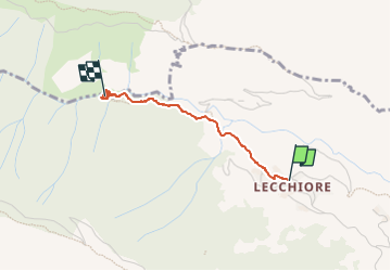
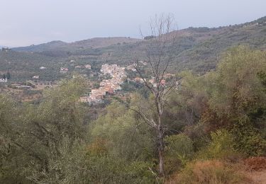
Randonnée Marche de 2,3 km à découvrir à Ligurie, Imperia, Dolcedo. Cette randonnée est proposée par patjobou.
Description
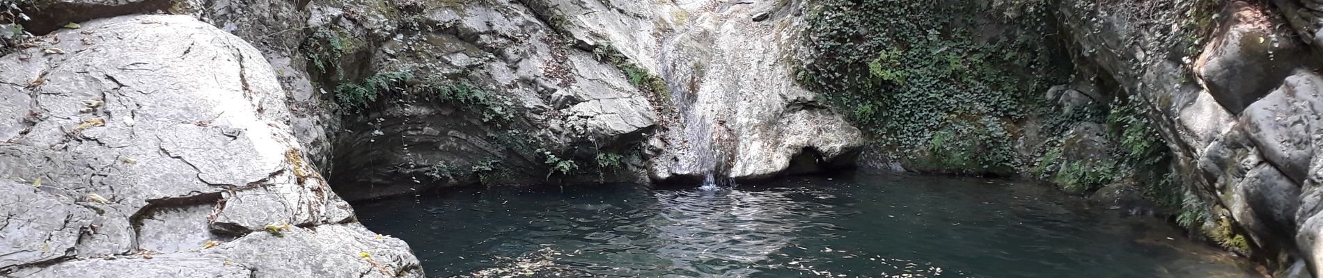
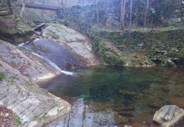
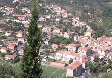
Un très beau coin pour se baigner dans des vasques. Pas trop fréquenté malgré une période peu propice début août, Très apprécié pendant la canicule ambiante. Bien se garer au village de Lecchiore, inutile de chercher à aller plus loin. La promenade à pied est agréable pour découvrir les vasques. Ne pas hésiter à continuer au-dessus de la vasque la plus connue et la plus fréquentée : celle équipée d'une balançoire ! Au-dessus encore de très belles vasques moins fréquentées. À partir de la vasque supérieure retour par un agréable sentier partiellement empierré qui ramène sur la piste du village.
Localisation
Commentaires
Randonnées à proximité
![Randonnée Marche Dolcedo - Laghetti di Lecchiore 27.12.24 - Photo](https://media.geolcdn.com/t/375/260/d506e64c-eb3e-486b-a8d3-1e3fb213dd22.jpg&format=jpg&maxdim=2)
![Marche Marche](https://static1.geolcdn.com/sitytour/trail-icons/101.png)
Marche
![](/images/other/stat-length.png)
![](https://static1.geolcdn.com/siteimages/upload/files/16400158638029165_repeat_loop_refresh_sync_direction_icon.png)
![Randonnée Marche Imperia - Montegrazie - Liguria - Photo](https://media.geolcdn.com/t/375/260/ec36081b-e2ea-43c3-9e89-bc805bd37dda.jpg&format=jpg&maxdim=2)
![Marche Marche](https://static1.geolcdn.com/sitytour/trail-icons/101.png)
Marche
![](/images/other/stat-length.png)
![](https://static1.geolcdn.com/siteimages/upload/files/16400158638029165_repeat_loop_refresh_sync_direction_icon.png)
![Randonnée A pied Dolcedo - AM2 - Alpi Mare 2 - Photo](https://media.geolcdn.com/t/375/260/125e51ae-9093-4c3b-a8c0-79fc8284b6db.jpeg&format=jpg&maxdim=2)
![A pied A pied](https://static1.geolcdn.com/sitytour/trail-icons/100.png)
A pied
![](/images/other/stat-length.png)
![](https://static1.geolcdn.com/siteimages/upload/files/16400158638029165_repeat_loop_refresh_sync_direction_icon.png)
![Randonnée A pied Dolcedo - Passeggiata dei Ponti - Photo](https://media.geolcdn.com/t/375/260/b1988f81-a6df-4330-ba2b-8f74d3e65878.jpeg&format=jpg&maxdim=2)
![A pied A pied](https://static1.geolcdn.com/sitytour/trail-icons/100.png)
A pied
![](/images/other/stat-length.png)
![](https://static1.geolcdn.com/siteimages/upload/files/16400158638029165_repeat_loop_refresh_sync_direction_icon.png)
![Randonnée A pied Prelà - Sentiero Balcone Mediterraneo T5 - Photo](https://media.geolcdn.com/t/375/260/4fa60e3a-4515-44fa-864f-856ed7078524.jpeg&format=jpg&maxdim=2)
![A pied A pied](https://static1.geolcdn.com/sitytour/trail-icons/100.png)
A pied
![](/images/other/stat-length.png)
![](https://static1.geolcdn.com/siteimages/upload/files/16400158638029165_repeat_loop_refresh_sync_direction_icon.png)
![Randonnée Marche Dolcedo - DOLCEDO Valloria - Photo](https://media.geolcdn.com/t/375/260/ext.jpg?maxdim=2&url=https%3A%2F%2Fstatic1.geolcdn.com%2Fsiteimages%2Fupload%2Ffiles%2F1553511878bg_sport_marche.png)
![Marche Marche](https://static1.geolcdn.com/sitytour/trail-icons/101.png)
Marche
![](/images/other/stat-length.png)
![](https://static1.geolcdn.com/siteimages/upload/files/16400158638029165_repeat_loop_refresh_sync_direction_icon.png)
![Randonnée A pied Dolcedo - Sentiero Balcone Mediterraneo T6 - Photo](https://media.geolcdn.com/t/375/260/ext.jpg?maxdim=2&url=https%3A%2F%2Fstatic1.geolcdn.com%2Fsiteimages%2Fupload%2Ffiles%2F1545311037marcheuse_200dpi.jpg)
![A pied A pied](https://static1.geolcdn.com/sitytour/trail-icons/100.png)
A pied
![](/images/other/stat-length.png)
![](https://static1.geolcdn.com/siteimages/upload/files/16400158638029165_repeat_loop_refresh_sync_direction_icon.png)
![Randonnée Marche Dolcedo - Mont faudo - Photo](https://media.geolcdn.com/t/375/260/ext.jpg?maxdim=2&url=https%3A%2F%2Fstatic1.geolcdn.com%2Fsiteimages%2Fupload%2Ffiles%2F1553511878bg_sport_marche.png)
![Marche Marche](https://static1.geolcdn.com/sitytour/trail-icons/101.png)
Marche
![](/images/other/stat-length.png)
![](https://static1.geolcdn.com/siteimages/upload/files/16400158638029165_repeat_loop_refresh_sync_direction_icon.png)
![Randonnée Marche Dolcedo - dolcedo Santa marta 28 fevrier - Photo](https://media.geolcdn.com/t/375/260/ext.jpg?maxdim=2&url=https%3A%2F%2Fstatic1.geolcdn.com%2Fsiteimages%2Fupload%2Ffiles%2F1553511878bg_sport_marche.png)
![Marche Marche](https://static1.geolcdn.com/sitytour/trail-icons/101.png)
Marche
![](/images/other/stat-length.png)
![](https://static1.geolcdn.com/siteimages/upload/files/16400158638029165_repeat_loop_refresh_sync_direction_icon.png)