![](/images/other/stat-length.png)
![Randonnée Marche Vinadio - du col de la lombarde à la cime du gros cheval - Photo](https://media.geolcdn.com/t/1900/400/c8cc34d6-77df-4817-8b59-ac2f5f8e75fd.jpg&format=pjpeg&maxdim=2)
du col de la lombarde à la cime du gros cheval
pln30
Utilisateur
![Longueur](/images/other/stat-length.png)
![Altitude max](https://static1.geolcdn.com/siteimages/upload/files/1508320355ic_sort_altitude_max_24dp.png)
![Dénivelé positif](https://static1.geolcdn.com/siteimages/upload/files/1508320355ic_sort_den_pos_24dp.png)
![Km-Effort](/images/other/stat-length.png)
![Altitude min](https://static1.geolcdn.com/siteimages/upload/files/1508320355ic_sort_altitude_min_24dp.png)
![Dénivelé négatif](https://static1.geolcdn.com/siteimages/upload/files/1508320355ic_sort_den_neg_24dp.png)
![Boucle](https://static1.geolcdn.com/siteimages/upload/files/16400158638029165_repeat_loop_refresh_sync_direction_icon.png)
![Marche](https://static1.geolcdn.com/sitytour/trail-icons/101.png)
1h42
Difficulté : Facile
![Scannez ce code QR pour ouvrir la randonnée dans l'application SityTrail](https://capi.geolives.com/qq0zvz2zws4bq2lad0pu/sitytour/trails/3346824/qr.png?size=200)
Application GPS de randonnée GRATUITE
À propos
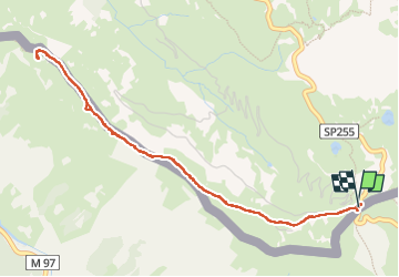
Randonnée Marche de 5,2 km à découvrir à Piémont, Coni, Vinadio. Cette randonnée est proposée par pln30.
Description
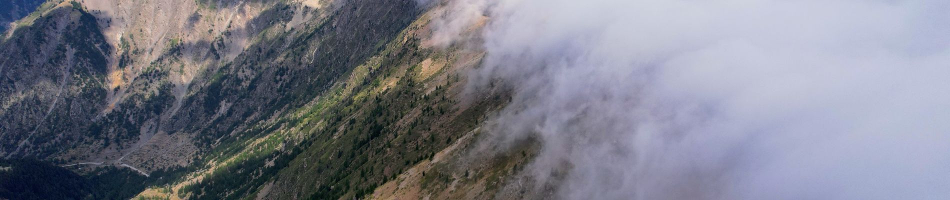
ce doit être un beau parcours malheureusement lorsque je l'ai fait un epais nuage est resté bloqué sur cette crête. heureusement j'ai pu voir au dessus avec mon drone. parrait il c'est assez fréquent sur cette ligne de crete.
toujours est il comme d'habitude vous retrouver la randonnée sur ma chaine youtube air view channel, le titre de la vidéo est la tête dans les nuages
Localisation
Commentaires
Randonnées à proximité
![Randonnée Autre activité Isola - Isola 2000 baisse Druos refuge Quesa - Photo](https://media.geolcdn.com/t/375/260/ext.jpg?maxdim=2&url=https%3A%2F%2Fservices.sitytrail.com%2FGeolivesWS%2FDownloadMedia.ashx%3FTrailID%3D631831%26Media%3Dfix__20160806152443.jpg)
![Autre activité Autre activité](https://static1.geolcdn.com/sitytour/trail-icons/900.png)
Autre activité
![](/images/other/stat-length.png)
![](https://static1.geolcdn.com/siteimages/upload/files/16400158638029165_repeat_loop_refresh_sync_direction_icon.png)
![Randonnée Marche Isola - Tête Mercière et Lacs de terre rouge 24.8.24 - Photo](https://media.geolcdn.com/t/375/260/3e3a1aaf-e381-4ca9-a18c-df28b1091979.jpg&format=jpg&maxdim=2)
![Marche Marche](https://static1.geolcdn.com/sitytour/trail-icons/101.png)
Marche
![](/images/other/stat-length.png)
![](https://static1.geolcdn.com/siteimages/upload/files/16400158638029165_repeat_loop_refresh_sync_direction_icon.png)
![Randonnée A pied Vinadio - Via Alpina Red R141 - Photo](https://media.geolcdn.com/t/375/260/e6824d5d-4c86-4be1-803c-c747aafeef5a.jpeg&format=jpg&maxdim=2)
![A pied A pied](https://static1.geolcdn.com/sitytour/trail-icons/100.png)
A pied
![](/images/other/stat-length.png)
![](https://static1.geolcdn.com/siteimages/upload/files/16400158638029165_repeat_loop_refresh_sync_direction_icon.png)
![Randonnée A pied Isola - Tête Mercière - Photo](https://media.geolcdn.com/t/375/260/8e1ca2e5-a446-45a1-b4b9-1747f6caafe0.jpeg&format=jpg&maxdim=2)
![A pied A pied](https://static1.geolcdn.com/sitytour/trail-icons/100.png)
A pied
![](/images/other/stat-length.png)
![](https://static1.geolcdn.com/siteimages/upload/files/16400158638029165_repeat_loop_refresh_sync_direction_icon.png)
![Randonnée A pied Vinadio - Tour du Lausfer - Photo](https://media.geolcdn.com/t/375/260/cc4c2b4d-e173-4a84-be7d-4686c9701dd6.jpeg&format=jpg&maxdim=2)
![A pied A pied](https://static1.geolcdn.com/sitytour/trail-icons/100.png)
![Randonnée A pied Vinadio - (SI E13) Sant'Anna di Vinadio - Vinadio Frazione Strepeis - Photo](https://media.geolcdn.com/t/375/260/2964e30b-263b-42c3-aa1c-ecaafebd0df1.jpeg&format=jpg&maxdim=2)
![A pied A pied](https://static1.geolcdn.com/sitytour/trail-icons/100.png)
A pied
![](/images/other/stat-length.png)
![](https://static1.geolcdn.com/siteimages/upload/files/16400158638029165_repeat_loop_refresh_sync_direction_icon.png)
![Randonnée A pied Vinadio - (SI E12) Rifugio Citta' di Ceva al Malinvern - Sant'Anna di Vinadio - Photo](https://media.geolcdn.com/t/375/260/e6824d5d-4c86-4be1-803c-c747aafeef5a.jpeg&format=jpg&maxdim=2)
![A pied A pied](https://static1.geolcdn.com/sitytour/trail-icons/100.png)
A pied
![](/images/other/stat-length.png)
![](https://static1.geolcdn.com/siteimages/upload/files/16400158638029165_repeat_loop_refresh_sync_direction_icon.png)
![Randonnée Marche Isola - cime de la lombarde - Photo](https://media.geolcdn.com/t/375/260/ext.jpg?maxdim=2&url=https%3A%2F%2Fstatic1.geolcdn.com%2Fsiteimages%2Fupload%2Ffiles%2F1553511878bg_sport_marche.png)
![Marche Marche](https://static1.geolcdn.com/sitytour/trail-icons/101.png)
Marche
![](/images/other/stat-length.png)
![](https://static1.geolcdn.com/siteimages/upload/files/16400158638029165_repeat_loop_refresh_sync_direction_icon.png)
![Randonnée Marche Vinadio - Cime de la Lombarde 2800m 26.8.24 - Photo](https://media.geolcdn.com/t/375/260/a90fbc15-b832-4be5-b4ba-c6dcb34efb02.jpg&format=jpg&maxdim=2)
![Marche Marche](https://static1.geolcdn.com/sitytour/trail-icons/101.png)
Marche
![](/images/other/stat-length.png)
![](https://static1.geolcdn.com/siteimages/upload/files/16400158638029165_repeat_loop_refresh_sync_direction_icon.png)