![](/images/other/stat-length.png)
![Randonnée La Bresse - 2022-08-08_07h41m53_montagne-trekking-randonnee-lac-du-schiessrothied-depuis-le-hohneck - Photo](https://media.geolcdn.com/t/1900/400/ext.pjpeg?maxdim=2&url=https%3A%2F%2Fsecurestorage.geolives.com%2Fsitytour%2Ftrail-bg%2Fdefault.jpg)
2022-08-08_07h41m53_montagne-trekking-randonnee-lac-du-schiessrothied-depuis-le-hohneck
ACPL
Utilisateur
![Longueur](/images/other/stat-length.png)
![Altitude max](https://static1.geolcdn.com/siteimages/upload/files/1508320355ic_sort_altitude_max_24dp.png)
![Dénivelé positif](https://static1.geolcdn.com/siteimages/upload/files/1508320355ic_sort_den_pos_24dp.png)
![Km-Effort](/images/other/stat-length.png)
![Altitude min](https://static1.geolcdn.com/siteimages/upload/files/1508320355ic_sort_altitude_min_24dp.png)
![Dénivelé négatif](https://static1.geolcdn.com/siteimages/upload/files/1508320355ic_sort_den_neg_24dp.png)
![Boucle](https://static1.geolcdn.com/siteimages/upload/files/16400158638029165_repeat_loop_refresh_sync_direction_icon.png)
![Scannez ce code QR pour ouvrir la randonnée dans l'application SityTrail](https://capi.geolives.com/qq0zvz2zws4bq2lad0pu/sitytour/trails/3346680/qr.png?size=200)
Application GPS de randonnée GRATUITE
À propos
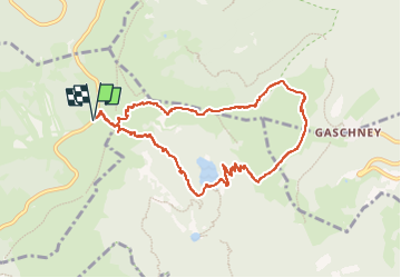
Randonnée de 8,8 km à découvrir à Grand Est, Vosges, La Bresse. Cette randonnée est proposée par ACPL.
Description
Départ au parking depuis la route des crêtes en bas du Hohneck
Lat/Lon : 48.03551/7.00748
1 / Prenez la route qui se situe a côté du restaurant â Pied du Hogneckâ pour monter au Hohneck. Puis tournez a droite pour prendre le sentier en direction du Lac de Schissrothied (balisage cercle bleu)
Lat/Lon : 48.03578/7.00798
2/ Continuez tout droit en direction de la vallée de la Wormsa, Lac du Schissrothied en suivant le balisage Triangle bleu
Lat/Lon : 48.03479/7.01079
3/ Continuez sur le sentier vers la gauche
Lat/Lon : 48.03441/7.01138
4/ Tournez a droite et suivez le triangle bleu
Lat/Lon : 48.03395/7.01601
5/ Lac du Schissrothied
Lat/Lon : 48.0287/7.02493
6/ Longer le lac du Schissrothied et prenez le GR 5 en direction du Hohneck pour atteindre lâauberge du Schissrothied (balisage rectangle rouge)
Lat/Lon : 48.02857/7.02519
7/ Continuez tout droit en direction de Schiessroth et Gashney GR5 en suivant le rectangle rouge et bleu
Lat/Lon : 48.02934/7.02704
8/ Puis tournez a gauche en direction du Schissroth GR5 (balisage rectangle rouge)
Lat/Lon : 48.02869/7.02799
9/ Une fois avoir passé lâauberge Schissrothied et la route, prenez le sentier en direction du Schallern Rothried en suivant le triangle bleu
Lat/Lon : 48.02944/7.03327
10/ Tournez a gauche et suivez le triangle bleu
Lat/Lon : 48.0364/7.03969
11/ Bifurquez vers la gauche en direction du Hohneck. Suivez le balisage rectangle rouge.
Lat/Lon : 48.03642/7.02572
12/ Source pour se ravitailler en eau
Lat/Lon : 48.03655/7.01952
13/ Vue panoramique du Hohneck
Lat/Lon : 48.03711/7.01675
14/ Arrivée au parking du pied du Hohneck
Lat/Lon : 48.03592/7.00828
Localisation
Commentaires
Randonnées à proximité
![Randonnée Marche La Bresse - 2023-04-16 Marche Abri Lac de Blanchemer vers Lac de Lispach - Photo](https://media.geolcdn.com/t/375/260/20b642e6-a3a8-4790-bc8e-b2ad298c0408.jpg&format=jpg&maxdim=2)
![Marche Marche](https://static1.geolcdn.com/sitytour/trail-icons/101.png)
Marche
![](/images/other/stat-length.png)
![](https://static1.geolcdn.com/siteimages/upload/files/16400158638029165_repeat_loop_refresh_sync_direction_icon.png)
![Randonnée Marche Le Valtin - Les Rochers des Hirschsteine - Lac Vert - Photo](https://media.geolcdn.com/t/375/260/4177d9e5-d8bc-4dac-ac45-c42f01ca30d3.jpg&format=jpg&maxdim=2)
![Marche Marche](https://static1.geolcdn.com/sitytour/trail-icons/101.png)
Marche
![](/images/other/stat-length.png)
![](https://static1.geolcdn.com/siteimages/upload/files/16400158638029165_repeat_loop_refresh_sync_direction_icon.png)
![Randonnée Marche La Bresse - Kastelberg des pierres, des lacs, des panoramas magnifiques - Photo](https://media.geolcdn.com/t/375/260/cada329c-fae7-4d3f-815e-38ed5d6ce361.jpg&format=jpg&maxdim=2)
![Marche Marche](https://static1.geolcdn.com/sitytour/trail-icons/101.png)
Marche
![](/images/other/stat-length.png)
![](https://static1.geolcdn.com/siteimages/upload/files/16400158638029165_repeat_loop_refresh_sync_direction_icon.png)
![Randonnée Marche Le Valtin - Col de la Schlucht - Photo](https://media.geolcdn.com/t/375/260/5b598871-c43c-4378-92fe-f06bddb4af29.jpg&format=jpg&maxdim=2)
![Marche Marche](https://static1.geolcdn.com/sitytour/trail-icons/101.png)
Marche
![](/images/other/stat-length.png)
![](https://static1.geolcdn.com/siteimages/upload/files/16400158638029165_repeat_loop_refresh_sync_direction_icon.png)
![Randonnée Marche Le Valtin - Le Sentier des Roches - Photo](https://media.geolcdn.com/t/375/260/f2737479-0e9e-43ec-9b66-c9706dc8ef91.jpg&format=jpg&maxdim=2)
![Marche Marche](https://static1.geolcdn.com/sitytour/trail-icons/101.png)
Marche
![](/images/other/stat-length.png)
![](https://static1.geolcdn.com/siteimages/upload/files/16400158638029165_repeat_loop_refresh_sync_direction_icon.png)
![Randonnée Marche La Bresse - Lac de Lispach et sentier Dielaine - Photo](https://media.geolcdn.com/t/375/260/b54731ea-6209-4cff-b7c0-af5225a4f3ae.jpg&format=jpg&maxdim=2)
![Marche Marche](https://static1.geolcdn.com/sitytour/trail-icons/101.png)
Marche
![](/images/other/stat-length.png)
![](https://static1.geolcdn.com/siteimages/upload/files/16400158638029165_repeat_loop_refresh_sync_direction_icon.png)
![Randonnée Marche Stosswihr - Tour du belvedere avec le passage sur les crêtes - Photo](https://media.geolcdn.com/t/375/260/5b3c85c1-2643-45e9-9769-80e100e05dda.jpg&format=jpg&maxdim=2)
![Marche Marche](https://static1.geolcdn.com/sitytour/trail-icons/101.png)
Marche
![](/images/other/stat-length.png)
![](https://static1.geolcdn.com/siteimages/upload/files/16400158638029165_repeat_loop_refresh_sync_direction_icon.png)
![Marche Marche](https://static1.geolcdn.com/sitytour/trail-icons/101.png)
Marche
![](/images/other/stat-length.png)
![](https://static1.geolcdn.com/siteimages/upload/files/16400158638029165_repeat_loop_refresh_sync_direction_icon.png)
![Randonnée Marche Wildenstein - Col du Bramont - Machey - Blanchemer - Photo](https://media.geolcdn.com/t/375/260/ext.jpg?maxdim=2&url=https%3A%2F%2Fservices.sitytrail.com%2FGeolivesWS%2FDownloadMedia.ashx%3FTrailID%3D450008%26Media%3Dfix__20150714143610.jpg)
![Marche Marche](https://static1.geolcdn.com/sitytour/trail-icons/101.png)
Marche
![](/images/other/stat-length.png)
![](https://static1.geolcdn.com/siteimages/upload/files/16400158638029165_repeat_loop_refresh_sync_direction_icon.png)