![](/images/other/stat-length.png)
![Randonnée Marche Saint-Christophe-en-Oisans - la Dibona - Photo](https://media.geolcdn.com/t/1900/400/ext.pjpeg?maxdim=2&url=https%3A%2F%2Fstatic1.geolcdn.com%2Fsiteimages%2Fupload%2Ffiles%2F1553511878bg_sport_marche.png)
la Dibona
hugo26
Utilisateur
![Longueur](/images/other/stat-length.png)
Longueur
11,1 km
![Altitude max](https://static1.geolcdn.com/siteimages/upload/files/1508320355ic_sort_altitude_max_24dp.png)
Altitude max
2796 m
![Dénivelé positif](https://static1.geolcdn.com/siteimages/upload/files/1508320355ic_sort_den_pos_24dp.png)
Dénivelé positif
1237 m
![Km-Effort](/images/other/stat-length.png)
Km-Effort
28 km
![Altitude min](https://static1.geolcdn.com/siteimages/upload/files/1508320355ic_sort_altitude_min_24dp.png)
Altitude min
1567 m
![Dénivelé négatif](https://static1.geolcdn.com/siteimages/upload/files/1508320355ic_sort_den_neg_24dp.png)
Dénivelé négatif
1234 m
![Boucle](https://static1.geolcdn.com/siteimages/upload/files/16400158638029165_repeat_loop_refresh_sync_direction_icon.png)
Boucle
Oui
Date de création :
2022-08-07 18:44:20.645
Dernière modification :
2022-08-07 18:47:50.222
![Marche](https://static1.geolcdn.com/sitytour/trail-icons/101.png)
6h16
Difficulté : Très difficile
![Scannez ce code QR pour ouvrir la randonnée dans l'application SityTrail](https://capi.geolives.com/qq0zvz2zws4bq2lad0pu/sitytour/trails/3346483/qr.png?size=200)
Application GPS de randonnée GRATUITE
À propos
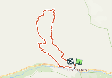
Randonnée Marche de 11,1 km à découvrir à Auvergne-Rhône-Alpes, Isère, Saint-Christophe-en-Oisans. Cette randonnée est proposée par hugo26.
Description
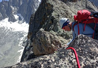
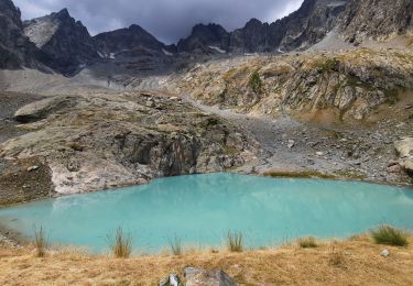
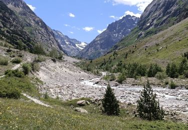
Rando en boucle depuis les Etages ( la Bérarde) vers le refuge du Soreiller et retour par basse montagne. Rando difficile à faire avec un maximum d'entrainement.
Localisation
Pays :
France
Région :
Auvergne-Rhône-Alpes
Département/Province :
Isère
Commune :
Saint-Christophe-en-Oisans
Localité :
Unknown
Départ:(Dec)
Départ:(UTM)
283418 ; 4979646 (32T) N.
Commentaires
Randonnées à proximité
![Randonnée Marche Saint-Christophe-en-Oisans - Saint-Christophe-en-Oisans - Vallon des Etages - 6.5km 375m 3h20 - 2018 06 19 - Photo](https://media.geolcdn.com/t/375/260/ext.jpg?maxdim=2&url=https%3A%2F%2Fservices.sitytrail.com%2FGeolivesWS%2FDownloadMedia.ashx%3FTrailID%3D999391%26Media%3Dfix__20180619093050.jpg)
![Marche Marche](https://static1.geolcdn.com/sitytour/trail-icons/101.png)
Saint-Christophe-en-Oisans - Vallon des Etages - 6.5km 375m 3h20 - 2018 06 19
Marche
Moyen
Saint-Christophe-en-Oisans,
Auvergne-Rhône-Alpes,
Isère,
France
![](/images/other/stat-length.png)
6,3 km | 11,2 km-effort
3h 20min
![](https://static1.geolcdn.com/siteimages/upload/files/16400158638029165_repeat_loop_refresh_sync_direction_icon.png)
Oui
![Randonnée Marche Saint-Christophe-en-Oisans - Saint-Christophe-en-Oisans - La Bérarde Cotillat (le Châtelleret) - 10.7km 390m 5h30 (45mn) - 2018 06 22 - Photo](https://media.geolcdn.com/t/375/260/ext.jpg?maxdim=2&url=https%3A%2F%2Fservices.sitytrail.com%2FGeolivesWS%2FDownloadMedia.ashx%3FTrailID%3D999336%26Media%3Dfix__20180622150554.jpg)
![Marche Marche](https://static1.geolcdn.com/sitytour/trail-icons/101.png)
Saint-Christophe-en-Oisans - La Bérarde Cotillat (le Châtelleret) - 10.7km 39...
Marche
Moyen
Saint-Christophe-en-Oisans,
Auvergne-Rhône-Alpes,
Isère,
France
![](/images/other/stat-length.png)
10,8 km | 16 km-effort
5h 30min
![](https://static1.geolcdn.com/siteimages/upload/files/16400158638029165_repeat_loop_refresh_sync_direction_icon.png)
Oui
![Randonnée Marche Saint-Christophe-en-Oisans - Saint-Christophe-en-Oisans - Vallée du Vénéon les Etages - 5.2km 170m 3h15 - 2015 06 25 - Photo](https://media.geolcdn.com/t/375/260/ext.jpg?maxdim=2&url=https%3A%2F%2Fservices.sitytrail.com%2FGeolivesWS%2FDownloadMedia.ashx%3FTrailID%3D440121%26Media%3Dfix__20150625110049.jpg)
![Marche Marche](https://static1.geolcdn.com/sitytour/trail-icons/101.png)
Saint-Christophe-en-Oisans - Vallée du Vénéon les Etages - 5.2km 170m 3h15 - ...
Marche
Facile
Saint-Christophe-en-Oisans,
Auvergne-Rhône-Alpes,
Isère,
France
![](/images/other/stat-length.png)
5,2 km | 7,6 km-effort
3h 15min
![](https://static1.geolcdn.com/siteimages/upload/files/16400158638029165_repeat_loop_refresh_sync_direction_icon.png)
Oui
![Randonnée Marche Saint-Christophe-en-Oisans - Saint-Christophe-en-Oisans - de Champhorent au Refuge de La Lavey - 12.9km 570m 5h40 (1h00) - 2015 06 24 - Photo](https://media.geolcdn.com/t/375/260/ext.jpg?maxdim=2&url=https%3A%2F%2Fservices.sitytrail.com%2FGeolivesWS%2FDownloadMedia.ashx%3FTrailID%3D440118%26Media%3Dfix__20150624154321.jpg)
![Marche Marche](https://static1.geolcdn.com/sitytour/trail-icons/101.png)
Saint-Christophe-en-Oisans - de Champhorent au Refuge de La Lavey - 12.9km 57...
Marche
Difficile
Saint-Christophe-en-Oisans,
Auvergne-Rhône-Alpes,
Isère,
France
![](/images/other/stat-length.png)
12,9 km | 21 km-effort
5h 40min
![](https://static1.geolcdn.com/siteimages/upload/files/16400158638029165_repeat_loop_refresh_sync_direction_icon.png)
Oui
![Randonnée Marche Saint-Christophe-en-Oisans - Saint-Christophe-en-Oisans - La Bérarde Refuge du Carrelet - 7.9km 220m 2h50 - 2015 06 20 - Photo](https://media.geolcdn.com/t/375/260/ext.jpg?maxdim=2&url=https%3A%2F%2Fservices.sitytrail.com%2FGeolivesWS%2FDownloadMedia.ashx%3FTrailID%3D436077%26Media%3Dfix__20150620162005.jpg)
![Marche Marche](https://static1.geolcdn.com/sitytour/trail-icons/101.png)
Saint-Christophe-en-Oisans - La Bérarde Refuge du Carrelet - 7.9km 220m 2h50 ...
Marche
Moyen
Saint-Christophe-en-Oisans,
Auvergne-Rhône-Alpes,
Isère,
France
![](/images/other/stat-length.png)
7,9 km | 10,8 km-effort
2h 50min
![](https://static1.geolcdn.com/siteimages/upload/files/16400158638029165_repeat_loop_refresh_sync_direction_icon.png)
Oui
![Randonnée Marche Saint-Christophe-en-Oisans - Saint-Christophe-en-Oisans - La Bérarde la Vallée du Vénéon - 13.4km 390m 4h00 (30mn) - 2014 06 08 - Photo](https://media.geolcdn.com/t/375/260/ext.jpg?maxdim=2&url=https%3A%2F%2Fservices.sitytrail.com%2FGeolivesWS%2FDownloadMedia.ashx%3FTrailID%3D311048%26Media%3Dfix__20140608163517.jpg)
![Marche Marche](https://static1.geolcdn.com/sitytour/trail-icons/101.png)
Saint-Christophe-en-Oisans - La Bérarde la Vallée du Vénéon - 13.4km 390m 4h0...
Marche
Moyen
Saint-Christophe-en-Oisans,
Auvergne-Rhône-Alpes,
Isère,
France
![](/images/other/stat-length.png)
13,4 km | 18,5 km-effort
4h 1min
![](https://static1.geolcdn.com/siteimages/upload/files/16400158638029165_repeat_loop_refresh_sync_direction_icon.png)
Oui
![Randonnée Marche Saint-Christophe-en-Oisans - Cornes de Pié Bérarde - Photo](https://media.geolcdn.com/t/375/260/b365defd-9ad4-4aa5-a793-661817e0b806.jpg&format=jpg&maxdim=2)
![Marche Marche](https://static1.geolcdn.com/sitytour/trail-icons/101.png)
Cornes de Pié Bérarde
Marche
Très difficile
Saint-Christophe-en-Oisans,
Auvergne-Rhône-Alpes,
Isère,
France
![](/images/other/stat-length.png)
9,8 km | 27 km-effort
6h 7min
![](https://static1.geolcdn.com/siteimages/upload/files/16400158638029165_repeat_loop_refresh_sync_direction_icon.png)
Oui
![Randonnée Marche Saint-Christophe-en-Oisans - Lac des Bèches - Photo](https://media.geolcdn.com/t/375/260/aed396ac-ba2f-4a61-b7da-cb061c5fa992.jpg&format=jpg&maxdim=2)
![Marche Marche](https://static1.geolcdn.com/sitytour/trail-icons/101.png)
Lac des Bèches
Marche
Très difficile
Saint-Christophe-en-Oisans,
Auvergne-Rhône-Alpes,
Isère,
France
![](/images/other/stat-length.png)
16 km | 31 km-effort
6h 33min
![](https://static1.geolcdn.com/siteimages/upload/files/16400158638029165_repeat_loop_refresh_sync_direction_icon.png)
Oui
![Randonnée Marche Saint-Christophe-en-Oisans - Rando depart du refuge du Carrelet et arrivée à La Berarde - Photo](https://media.geolcdn.com/t/375/260/ba3f2593-4b51-48ac-977d-c1aae9a6266f.jpg&format=jpg&maxdim=2)
![Marche Marche](https://static1.geolcdn.com/sitytour/trail-icons/101.png)
Rando depart du refuge du Carrelet et arrivée à La Berarde
Marche
Facile
Saint-Christophe-en-Oisans,
Auvergne-Rhône-Alpes,
Isère,
France
![](/images/other/stat-length.png)
4,4 km | 5,3 km-effort
1h 10min
![](https://static1.geolcdn.com/siteimages/upload/files/16400158638029165_repeat_loop_refresh_sync_direction_icon.png)
Non