![](/images/other/stat-length.png)
![Randonnée Vélo Joué-l'Abbé - Cols en Sarthe et Mayenne - Photo](https://media.geolcdn.com/t/1900/400/ext.pjpeg?maxdim=2&url=https%3A%2F%2Fstatic1.geolcdn.com%2Fsiteimages%2Fupload%2Ffiles%2F1524743154velo.jpg)
Cols en Sarthe et Mayenne
bosses21
Utilisateur
![Longueur](/images/other/stat-length.png)
Longueur
119 km
![Altitude max](https://static1.geolcdn.com/siteimages/upload/files/1508320355ic_sort_altitude_max_24dp.png)
Altitude max
287 m
![Dénivelé positif](https://static1.geolcdn.com/siteimages/upload/files/1508320355ic_sort_den_pos_24dp.png)
Dénivelé positif
1533 m
![Km-Effort](/images/other/stat-length.png)
Km-Effort
140 km
![Altitude min](https://static1.geolcdn.com/siteimages/upload/files/1508320355ic_sort_altitude_min_24dp.png)
Altitude min
49 m
![Dénivelé négatif](https://static1.geolcdn.com/siteimages/upload/files/1508320355ic_sort_den_neg_24dp.png)
Dénivelé négatif
1533 m
![Boucle](https://static1.geolcdn.com/siteimages/upload/files/16400158638029165_repeat_loop_refresh_sync_direction_icon.png)
Boucle
Oui
Date de création :
2014-12-10 00:00:00.0
Dernière modification :
2014-12-10 00:00:00.0
![Vélo](https://static1.geolcdn.com/sitytour/trail-icons/200.png)
7h55
Difficulté : Moyen
![Scannez ce code QR pour ouvrir la randonnée dans l'application SityTrail](https://capi.geolives.com/qq0zvz2zws4bq2lad0pu/sitytour/trails/334323/qr.png?size=200)
Application GPS de randonnée GRATUITE
À propos
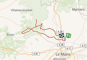
Randonnée Vélo de 119 km à découvrir à Pays de la Loire, Sarthe, Joué-l'Abbé. Cette randonnée est proposée par bosses21.
Description
Col de la Galerie - 258m
Col de la Vallée - 230m
Col de la Croix Lamare - 273m
Col de la Croix des 6 chemins - 168m
Col de la Source - 243m
Localisation
Pays :
France
Région :
Pays de la Loire
Département/Province :
Sarthe
Commune :
Joué-l'Abbé
Localité :
Unknown
Départ:(Dec)
Départ:(UTM)
292988 ; 5332173 (31U) N.
Commentaires
Randonnées à proximité
![Randonnée Marche Souillé - Souillé circuit chanvre - Photo](https://media.geolcdn.com/t/375/260/ext.jpg?maxdim=2&url=https%3A%2F%2Fservices.sitytrail.com%2FGeolivesWS%2FDownloadMedia.ashx%3FTrailID%3D1036938%26Media%3D20180909152027.jpg)
![Marche Marche](https://static1.geolcdn.com/sitytour/trail-icons/101.png)
Souillé circuit chanvre
Marche
Très facile
(1)
Souillé,
Pays de la Loire,
Sarthe,
France
![](/images/other/stat-length.png)
8,8 km | 9,6 km-effort
2h 0min
![](https://static1.geolcdn.com/siteimages/upload/files/16400158638029165_repeat_loop_refresh_sync_direction_icon.png)
Oui
![Randonnée Vélo Joué-l'Abbé - Cols en Sarthe - Photo](https://media.geolcdn.com/t/375/260/ext.jpg?maxdim=2&url=https%3A%2F%2Fstatic1.geolcdn.com%2Fsiteimages%2Fupload%2Ffiles%2F1524743154velo.jpg)
![Vélo Vélo](https://static1.geolcdn.com/sitytour/trail-icons/200.png)
Cols en Sarthe
Vélo
Moyen
Joué-l'Abbé,
Pays de la Loire,
Sarthe,
France
![](/images/other/stat-length.png)
104 km | 120 km-effort
6h 51min
![](https://static1.geolcdn.com/siteimages/upload/files/16400158638029165_repeat_loop_refresh_sync_direction_icon.png)
Non
![Randonnée Marche nordique Neuville-sur-Sarthe - Neuville sur Sarthe - Photo](https://media.geolcdn.com/t/375/260/ext.jpg?maxdim=2&url=https%3A%2F%2Fstatic1.geolcdn.com%2Fsiteimages%2Fupload%2Ffiles%2F1545311037marcheuse_200dpi.jpg)
![Marche nordique Marche nordique](https://static1.geolcdn.com/sitytour/trail-icons/102.png)
Neuville sur Sarthe
Marche nordique
Moyen
Neuville-sur-Sarthe,
Pays de la Loire,
Sarthe,
France
![](/images/other/stat-length.png)
7,4 km | 8 km-effort
1h 37min
![](https://static1.geolcdn.com/siteimages/upload/files/16400158638029165_repeat_loop_refresh_sync_direction_icon.png)
Oui
![Randonnée Marche Sainte-Jamme-sur-Sarthe - La Sarthe-04-Montbizot - Le Mans - Photo](https://media.geolcdn.com/t/375/260/ext.jpg?maxdim=2&url=https%3A%2F%2Fstatic1.geolcdn.com%2Fsiteimages%2Fupload%2Ffiles%2F1553511878bg_sport_marche.png)
![Marche Marche](https://static1.geolcdn.com/sitytour/trail-icons/101.png)
La Sarthe-04-Montbizot - Le Mans
Marche
Facile
Sainte-Jamme-sur-Sarthe,
Pays de la Loire,
Sarthe,
France
![](/images/other/stat-length.png)
22 km | 23 km-effort
5h 9min
![](https://static1.geolcdn.com/siteimages/upload/files/16400158638029165_repeat_loop_refresh_sync_direction_icon.png)
Non
![Randonnée Vélo Saint-Saturnin - training 1 - Photo](https://media.geolcdn.com/t/375/260/ext.jpg?maxdim=2&url=https%3A%2F%2Fstatic1.geolcdn.com%2Fsiteimages%2Fupload%2Ffiles%2F1524743154velo.jpg)
![Vélo Vélo](https://static1.geolcdn.com/sitytour/trail-icons/200.png)
training 1
Vélo
Très facile
Saint-Saturnin,
Pays de la Loire,
Sarthe,
France
![](/images/other/stat-length.png)
52 km | 59 km-effort
2h 28min
![](https://static1.geolcdn.com/siteimages/upload/files/16400158638029165_repeat_loop_refresh_sync_direction_icon.png)
Oui
![Randonnée Marche Souillé - Ste Jamme - La Bazoge - Photo](https://media.geolcdn.com/t/375/260/ext.jpg?maxdim=2&url=https%3A%2F%2Fservices.sitytrail.com%2FGeolivesWS%2FDownloadMedia.ashx%3FTrailID%3D67862%26Media%3D20110618145056.jpg)
![Marche Marche](https://static1.geolcdn.com/sitytour/trail-icons/101.png)
Ste Jamme - La Bazoge
Marche
Très facile
Souillé,
Pays de la Loire,
Sarthe,
France
![](/images/other/stat-length.png)
4,4 km | 4,9 km-effort
2h 16min
![](https://static1.geolcdn.com/siteimages/upload/files/16400158638029165_repeat_loop_refresh_sync_direction_icon.png)
Non
![Randonnée Marche La Bazoge - Super U chemin Creu - Photo](https://media.geolcdn.com/t/375/260/ext.jpg?maxdim=2&url=https%3A%2F%2Fstatic1.geolcdn.com%2Fsiteimages%2Fupload%2Ffiles%2F1553511878bg_sport_marche.png)
![Marche Marche](https://static1.geolcdn.com/sitytour/trail-icons/101.png)
Super U chemin Creu
Marche
Facile
La Bazoge,
Pays de la Loire,
Sarthe,
France
![](/images/other/stat-length.png)
4,3 km | 5,2 km-effort
1h 10min
![](https://static1.geolcdn.com/siteimages/upload/files/16400158638029165_repeat_loop_refresh_sync_direction_icon.png)
Oui
![Randonnée Marche nordique Neuville-sur-Sarthe - Neuville-sur-Sarthe super grand tour - Photo](https://media.geolcdn.com/t/375/260/ext.jpg?maxdim=2&url=https%3A%2F%2Fstatic1.geolcdn.com%2Fsiteimages%2Fupload%2Ffiles%2F1545311037marcheuse_200dpi.jpg)
![Marche nordique Marche nordique](https://static1.geolcdn.com/sitytour/trail-icons/102.png)
Neuville-sur-Sarthe super grand tour
Marche nordique
Moyen
Neuville-sur-Sarthe,
Pays de la Loire,
Sarthe,
France
![](/images/other/stat-length.png)
10,1 km | 11 km-effort
2h 22min
![](https://static1.geolcdn.com/siteimages/upload/files/16400158638029165_repeat_loop_refresh_sync_direction_icon.png)
Oui
![Randonnée Marche nordique Neuville-sur-Sarthe - Neuville-sur-Sarthe petite boucle - Photo](https://media.geolcdn.com/t/375/260/ext.jpg?maxdim=2&url=https%3A%2F%2Fstatic1.geolcdn.com%2Fsiteimages%2Fupload%2Ffiles%2F1545311037marcheuse_200dpi.jpg)
![Marche nordique Marche nordique](https://static1.geolcdn.com/sitytour/trail-icons/102.png)
Neuville-sur-Sarthe petite boucle
Marche nordique
Facile
Neuville-sur-Sarthe,
Pays de la Loire,
Sarthe,
France
![](/images/other/stat-length.png)
7,3 km | 7,9 km-effort
1h 36min
![](https://static1.geolcdn.com/siteimages/upload/files/16400158638029165_repeat_loop_refresh_sync_direction_icon.png)
Oui