Randonnée Marche Gemeinde Gries im Sellrain - Juifenalm - Photo
 FPFSB
FPFSB

Utilisateur

© OpenStreetMap contributors
Longueur
Longueur
8,5 km
Altitude max
Altitude max
1760 m
Dénivelé positif
Dénivelé positif
576 m
Km-Effort
Km-Effort  
16,3 km
Altitude min
Altitude min
1189 m
Dénivelé négatif
Dénivelé négatif
599 m
Boucle
Boucle
Non
Date de création :
2022-08-04 09:23:48.0
Dernière modification :
2022-08-04 13:36:56.299

(0 Avis)

Marche
Marche
4h12
Difficulté : Difficile

Scannez ce code QR pour ouvrir la randonnée dans l'application SityTrail

Application GPS de randonnée GRATUITE

Logo SityTrail SityTrail

IGN / Instituts géographiques

Télécharger SityTrail sur l'App Store Télécharger SityTrail sur Google Play

Logo SityTrail SityTrail World

Le monde est à vous

Télécharger SityTrail sur l'App Store Télécharger SityTrail sur Google Play Télécharger SityTrail sur Huawei AppGallery

À propos

Randonnée Marche de 8,5 km à découvrir à Tyrol, Bezirk Innsbruck-Land, Gemeinde Gries im Sellrain. Cette randonnée est proposée par FPFSB.

Profil altimétrique

Localisation

Pays :
Autriche
Région :
Tyrol
Département/Province :
Bezirk Innsbruck-Land
Commune :
Gemeinde Gries im Sellrain
Localité :
Unknown
Départ:(Dec)
Départ:(UTM)
663202 ; 5228774 (32T) N.

Randonnées à proximité

Randonnée Marche Gemeinde Gries im Sellrain - vallee sellrin - Photo
Marche
Nicole SIMONNET

Marche

Difficile
Gemeinde Gries im Sellrain, Tyrol, Bezirk Innsbruck-Land, Autriche
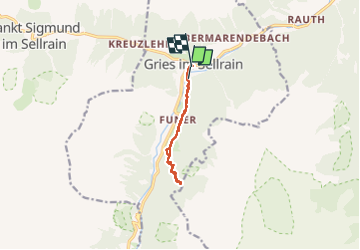
9,4 km | 18,6 km-effort
4h 33min
Non
Randonnée Marche Gemeinde Gries im Sellrain - Innsbrucker Bankl - Photo
Marche
FPFSB

Marche

Moyen
Gemeinde Gries im Sellrain, Tyrol, Bezirk Innsbruck-Land, Autriche
6,4 km | 10,3 km-effort
2h 34min
Oui
Randonnée Marche Gemeinde Sellrain - oberfuss - Photo
Marche
Nicole SIMONNET

Marche

Difficile
Gemeinde Sellrain, Tyrol, Bezirk Innsbruck-Land, Autriche
13 km | 25 km-effort
5h 55min
Non


Fermer
Mes abonnements