![](/images/other/stat-length.png)
![Randonnée Marche Froidchapelle - Vergnies promenade n°6 (Froidchapelle) - Photo](https://media.geolcdn.com/t/1900/400/ext.pjpeg?maxdim=2&url=https%3A%2F%2Fstatic1.geolcdn.com%2Fsiteimages%2Fupload%2Ffiles%2F1553511878bg_sport_marche.png)
Vergnies promenade n°6 (Froidchapelle)
lucspa
Utilisateur
![Longueur](/images/other/stat-length.png)
Longueur
6,4 km
![Altitude max](https://static1.geolcdn.com/siteimages/upload/files/1508320355ic_sort_altitude_max_24dp.png)
Altitude max
258 m
![Dénivelé positif](https://static1.geolcdn.com/siteimages/upload/files/1508320355ic_sort_den_pos_24dp.png)
Dénivelé positif
55 m
![Km-Effort](/images/other/stat-length.png)
Km-Effort
7,2 km
![Altitude min](https://static1.geolcdn.com/siteimages/upload/files/1508320355ic_sort_altitude_min_24dp.png)
Altitude min
223 m
![Dénivelé négatif](https://static1.geolcdn.com/siteimages/upload/files/1508320355ic_sort_den_neg_24dp.png)
Dénivelé négatif
56 m
![Boucle](https://static1.geolcdn.com/siteimages/upload/files/16400158638029165_repeat_loop_refresh_sync_direction_icon.png)
Boucle
Oui
Date de création :
2014-12-10 00:00:00.0
Dernière modification :
2020-07-27 09:06:04.876
![Marche](https://static1.geolcdn.com/sitytour/trail-icons/101.png)
1h35
Difficulté : Facile
![Scannez ce code QR pour ouvrir la randonnée dans l'application SityTrail](https://capi.geolives.com/qq0zvz2zws4bq2lad0pu/sitytour/trails/334098/qr.png?size=200)
Application GPS de randonnée GRATUITE
À propos
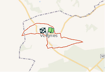
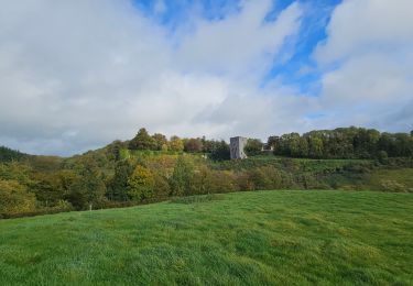
Randonnée Marche de 6,4 km à découvrir à Wallonie, Hainaut, Froidchapelle. Cette randonnée est proposée par lucspa.
Description
Vergnies promenade n°6 à contre-sens passage de L'Agaise (rue du château) vers rue Croix Courbain "difficile" dans sa 1re partie. A l'arrivée ou au départ, ne pas oublier d'aller voir l'église.
Localisation
Pays :
Belgique
Région :
Wallonie
Département/Province :
Hainaut
Commune :
Froidchapelle
Localité :
Vergnies
Départ:(Dec)
Départ:(UTM)
593141 ; 5561476 (31U) N.
Commentaires
Randonnées à proximité
![Randonnée Marche Beaumont - RB-Ha-09 - Beaumont - Photo](https://media.geolcdn.com/t/375/260/ext.jpg?maxdim=2&url=https%3A%2F%2Fservices.sitytrail.com%2FGeolivesWS%2FDownloadMedia.ashx%3FTrailID%3D179603%26Media%3D002b3a7c-9538-44ac-b480-ff7140afcc31.jpg)
![Marche Marche](https://static1.geolcdn.com/sitytour/trail-icons/101.png)
RB-Ha-09 - Beaumont
Marche
Très difficile
(4)
Beaumont,
Wallonie,
Hainaut,
Belgique
![](/images/other/stat-length.png)
23 km | 28 km-effort
6h 23min
![](https://static1.geolcdn.com/siteimages/upload/files/16400158638029165_repeat_loop_refresh_sync_direction_icon.png)
Oui
![Randonnée Marche Beaumont - Promenade à Beaumont - Photo](https://media.geolcdn.com/t/375/260/ext.jpg?maxdim=2&url=https%3A%2F%2Fservices.sitytrail.com%2FGeolivesWS%2FDownloadMedia.ashx%3FTrailID%3D171285%26Media%3D50fe5ef8-f61c-4575-9a4b-91e95871a668.JPG)
![Marche Marche](https://static1.geolcdn.com/sitytour/trail-icons/101.png)
Promenade à Beaumont
Marche
Très facile
(1)
Beaumont,
Wallonie,
Hainaut,
Belgique
![](/images/other/stat-length.png)
3,6 km | 5,1 km-effort
1h 5min
![](https://static1.geolcdn.com/siteimages/upload/files/16400158638029165_repeat_loop_refresh_sync_direction_icon.png)
Oui
![Randonnée Marche Beaumont - Balade à Barbençon - Photo](https://media.geolcdn.com/t/375/260/ext.jpg?maxdim=2&url=https%3A%2F%2Fservices.sitytrail.com%2FGeolivesWS%2FDownloadMedia.ashx%3FTrailID%3D574193%26Media%3Daac4060b-4d77-4046-9b2c-7fb6427c1e9c.jpg)
![Marche Marche](https://static1.geolcdn.com/sitytour/trail-icons/101.png)
Balade à Barbençon
Marche
Très facile
(3)
Beaumont,
Wallonie,
Hainaut,
Belgique
![](/images/other/stat-length.png)
8 km | 9,6 km-effort
2h 4min
![](https://static1.geolcdn.com/siteimages/upload/files/16400158638029165_repeat_loop_refresh_sync_direction_icon.png)
Oui
![Randonnée Vélo Beaumont - Parcours Napoléon - Photo](https://media.geolcdn.com/t/375/260/ext.jpg?maxdim=2&url=https%3A%2F%2Fstatic1.geolcdn.com%2Fsiteimages%2Fupload%2Ffiles%2F1524743154velo.jpg)
![Vélo Vélo](https://static1.geolcdn.com/sitytour/trail-icons/200.png)
Parcours Napoléon
Vélo
Moyen
(1)
Beaumont,
Wallonie,
Hainaut,
Belgique
![](/images/other/stat-length.png)
23 km | 26 km-effort
1h 30min
![](https://static1.geolcdn.com/siteimages/upload/files/16400158638029165_repeat_loop_refresh_sync_direction_icon.png)
Non
![Randonnée Marche Beaumont - Promenade vers Barbencon - Photo](https://media.geolcdn.com/t/375/260/ext.jpg?maxdim=2&url=https%3A%2F%2Fstatic1.geolcdn.com%2Fsiteimages%2Fupload%2Ffiles%2F1553511878bg_sport_marche.png)
![Marche Marche](https://static1.geolcdn.com/sitytour/trail-icons/101.png)
Promenade vers Barbencon
Marche
Très facile
(1)
Beaumont,
Wallonie,
Hainaut,
Belgique
![](/images/other/stat-length.png)
7,8 km | 9,4 km-effort
2h 0min
![](https://static1.geolcdn.com/siteimages/upload/files/16400158638029165_repeat_loop_refresh_sync_direction_icon.png)
Oui
![Randonnée Marche Beaumont - Balade transfrontaliere - De Beaumont vers Reugnies - Photo](https://media.geolcdn.com/t/375/260/ext.jpg?maxdim=2&url=https%3A%2F%2Fstatic1.geolcdn.com%2Fsiteimages%2Fupload%2Ffiles%2F1553511878bg_sport_marche.png)
![Marche Marche](https://static1.geolcdn.com/sitytour/trail-icons/101.png)
Balade transfrontaliere - De Beaumont vers Reugnies
Marche
Facile
(3)
Beaumont,
Wallonie,
Hainaut,
Belgique
![](/images/other/stat-length.png)
10,6 km | 13,4 km-effort
2h 35min
![](https://static1.geolcdn.com/siteimages/upload/files/16400158638029165_repeat_loop_refresh_sync_direction_icon.png)
Oui
![Randonnée Marche Beaumont - Balade à Beaumont - Photo](https://media.geolcdn.com/t/375/260/bc170cb1-0602-4a15-ab72-f6a142468558.jpg&format=jpg&maxdim=2)
![Marche Marche](https://static1.geolcdn.com/sitytour/trail-icons/101.png)
Balade à Beaumont
Marche
Moyen
Beaumont,
Wallonie,
Hainaut,
Belgique
![](/images/other/stat-length.png)
8,3 km | 10,5 km-effort
2h 22min
![](https://static1.geolcdn.com/siteimages/upload/files/16400158638029165_repeat_loop_refresh_sync_direction_icon.png)
Oui
![Randonnée Marche Froidchapelle - La balade du bois du Grand Oupia aux lacs de l'eau d'heure - Photo](https://media.geolcdn.com/t/375/260/73ecda4c-85a4-4092-8a72-382e3ad583a2.jpg&format=jpg&maxdim=2)
![Marche Marche](https://static1.geolcdn.com/sitytour/trail-icons/101.png)
La balade du bois du Grand Oupia aux lacs de l'eau d'heure
Marche
Moyen
(4)
Froidchapelle,
Wallonie,
Hainaut,
Belgique
![](/images/other/stat-length.png)
8,7 km | 9,9 km-effort
2h 15min
![](https://static1.geolcdn.com/siteimages/upload/files/16400158638029165_repeat_loop_refresh_sync_direction_icon.png)
Oui
![Randonnée Marche Froidchapelle - Balade au Lac de la Plate Taille - Photo](https://media.geolcdn.com/t/375/260/427a13d1-6de9-495e-8227-ecb1c99818d2.jpeg&format=jpg&maxdim=2)
![Marche Marche](https://static1.geolcdn.com/sitytour/trail-icons/101.png)
Balade au Lac de la Plate Taille
Marche
Moyen
Froidchapelle,
Wallonie,
Hainaut,
Belgique
![](/images/other/stat-length.png)
8,4 km | 9,8 km-effort
2h 57min
![](https://static1.geolcdn.com/siteimages/upload/files/16400158638029165_repeat_loop_refresh_sync_direction_icon.png)
Oui
très campagnards