![](/images/other/stat-length.png)
![Randonnée Marche Prags - Braies - Strudelkopf - Monte Specie 2307m - Photo](https://media.geolcdn.com/t/1900/400/8468876c-e2a9-4b49-a53c-2956bfdebd75.jpg&format=pjpeg&maxdim=2)
Strudelkopf - Monte Specie 2307m
VacheKiri67
Utilisateur
![Longueur](/images/other/stat-length.png)
Longueur
11,7 km
![Altitude max](https://static1.geolcdn.com/siteimages/upload/files/1508320355ic_sort_altitude_max_24dp.png)
Altitude max
2301 m
![Dénivelé positif](https://static1.geolcdn.com/siteimages/upload/files/1508320355ic_sort_den_pos_24dp.png)
Dénivelé positif
422 m
![Km-Effort](/images/other/stat-length.png)
Km-Effort
17,3 km
![Altitude min](https://static1.geolcdn.com/siteimages/upload/files/1508320355ic_sort_altitude_min_24dp.png)
Altitude min
1964 m
![Dénivelé négatif](https://static1.geolcdn.com/siteimages/upload/files/1508320355ic_sort_den_neg_24dp.png)
Dénivelé négatif
422 m
![Boucle](https://static1.geolcdn.com/siteimages/upload/files/16400158638029165_repeat_loop_refresh_sync_direction_icon.png)
Boucle
Oui
Date de création :
2022-07-22 07:17:25.879
Dernière modification :
2022-07-25 08:24:12.579
![Marche](https://static1.geolcdn.com/sitytour/trail-icons/101.png)
4h49
Difficulté : Moyen
![Scannez ce code QR pour ouvrir la randonnée dans l'application SityTrail](https://capi.geolives.com/qq0zvz2zws4bq2lad0pu/sitytour/trails/3325257/qr.png?size=200)
Application GPS de randonnée GRATUITE
À propos
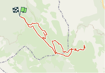
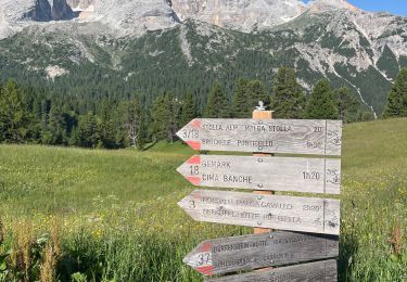
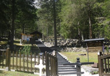
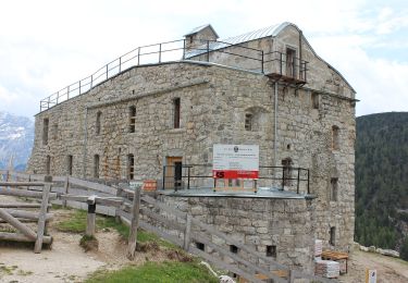
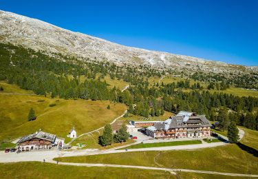
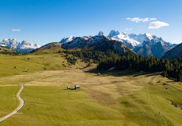
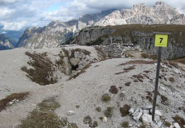
Randonnée Marche de 11,7 km à découvrir à Trentin-Haut-Adige, Haut-Adige, Prags - Braies. Cette randonnée est proposée par VacheKiri67.
Description
Faite le 22/07/2022.
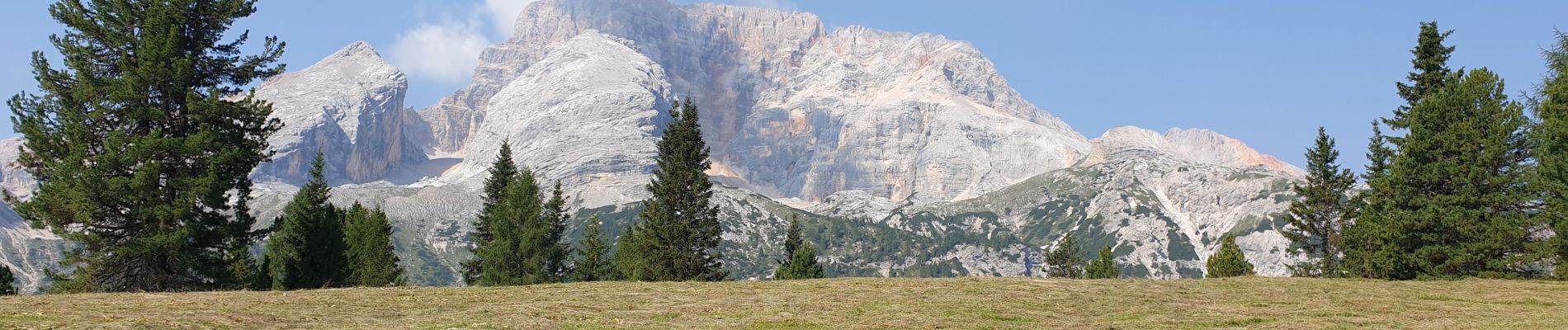
Pragser tal - Valle di Braies
Très beau parcours avec un panorama à 360° sur les Dolomites.
Au départ du parking Plätzwiese Pratopiazza 1979m.
Attention le parking est limité et la route fermée après 9h30.
Localisation
Pays :
Italie
Région :
Trentin-Haut-Adige
Département/Province :
Haut-Adige
Commune :
Prags - Braies
Localité :
Unknown
Départ:(Dec)
Départ:(UTM)
283815 ; 5170914 (33T) N.
Commentaires
Randonnées à proximité
![Randonnée Marche Prags - Braies - J4 Refuge Biella - Photo](https://media.geolcdn.com/t/375/260/492e9513-ea80-492c-8253-d34745130f32.jpg&format=jpg&maxdim=2)
![Marche Marche](https://static1.geolcdn.com/sitytour/trail-icons/101.png)
J4 Refuge Biella
Marche
Très difficile
Prags - Braies,
Trentin-Haut-Adige,
Haut-Adige,
Italie
![](/images/other/stat-length.png)
12 km | 22 km-effort
4h 55min
![](https://static1.geolcdn.com/siteimages/upload/files/16400158638029165_repeat_loop_refresh_sync_direction_icon.png)
Non
![Randonnée A pied Niederdorf - Villabassa - IT-33 - Photo](https://media.geolcdn.com/t/375/260/eff9106f-eb32-4ecc-b4cb-109d54866e3f.jpeg&format=jpg&maxdim=2)
![A pied A pied](https://static1.geolcdn.com/sitytour/trail-icons/100.png)
IT-33
A pied
Facile
Niederdorf - Villabassa,
Trentin-Haut-Adige,
Haut-Adige,
Italie
![](/images/other/stat-length.png)
6,8 km | 11,3 km-effort
2h 33min
![](https://static1.geolcdn.com/siteimages/upload/files/16400158638029165_repeat_loop_refresh_sync_direction_icon.png)
Non
![Randonnée A pied Toblach - Dobbiaco - IT-14 - Photo](https://media.geolcdn.com/t/375/260/293539e0-b295-4d50-bed9-482fd39c8c6a.jpeg&format=jpg&maxdim=2)
![A pied A pied](https://static1.geolcdn.com/sitytour/trail-icons/100.png)
IT-14
A pied
Facile
Toblach - Dobbiaco,
Trentin-Haut-Adige,
Haut-Adige,
Italie
![](/images/other/stat-length.png)
4,8 km | 7,5 km-effort
1h 42min
![](https://static1.geolcdn.com/siteimages/upload/files/16400158638029165_repeat_loop_refresh_sync_direction_icon.png)
Non
![Randonnée A pied Toblach - Dobbiaco - IT-40A - Photo](https://media.geolcdn.com/t/375/260/43891ad3-3705-4ecf-8800-9567e8294419.jpeg&format=jpg&maxdim=2)
![A pied A pied](https://static1.geolcdn.com/sitytour/trail-icons/100.png)
IT-40A
A pied
Facile
Toblach - Dobbiaco,
Trentin-Haut-Adige,
Haut-Adige,
Italie
![](/images/other/stat-length.png)
6,3 km | 11,1 km-effort
2h 31min
![](https://static1.geolcdn.com/siteimages/upload/files/16400158638029165_repeat_loop_refresh_sync_direction_icon.png)
Non
![Randonnée A pied Toblach - Dobbiaco - IT-34 - Photo](https://media.geolcdn.com/t/375/260/446455bc-f23e-463a-8951-9c95d3a75a14.jpeg&format=jpg&maxdim=2)
![A pied A pied](https://static1.geolcdn.com/sitytour/trail-icons/100.png)
IT-34
A pied
Facile
Toblach - Dobbiaco,
Trentin-Haut-Adige,
Haut-Adige,
Italie
![](/images/other/stat-length.png)
7,4 km | 16,5 km-effort
3h 44min
![](https://static1.geolcdn.com/siteimages/upload/files/16400158638029165_repeat_loop_refresh_sync_direction_icon.png)
Non
![Randonnée A pied Prags - Braies - IT-40 - Photo](https://media.geolcdn.com/t/375/260/9552e394-dca4-4688-89ff-17e6808fb936.jpeg&format=jpg&maxdim=2)
![A pied A pied](https://static1.geolcdn.com/sitytour/trail-icons/100.png)
IT-40
A pied
Facile
Prags - Braies,
Trentin-Haut-Adige,
Haut-Adige,
Italie
![](/images/other/stat-length.png)
4 km | 12 km-effort
2h 43min
![](https://static1.geolcdn.com/siteimages/upload/files/16400158638029165_repeat_loop_refresh_sync_direction_icon.png)
Non
![Randonnée A pied Prags - Braies - IT-3 - Photo](https://media.geolcdn.com/t/375/260/a2b48c89-8c86-4e24-8c1a-eb4d105308fd.jpeg&format=jpg&maxdim=2)
![A pied A pied](https://static1.geolcdn.com/sitytour/trail-icons/100.png)
IT-3
A pied
Facile
Prags - Braies,
Trentin-Haut-Adige,
Haut-Adige,
Italie
![](/images/other/stat-length.png)
9,7 km | 17,3 km-effort
3h 55min
![](https://static1.geolcdn.com/siteimages/upload/files/16400158638029165_repeat_loop_refresh_sync_direction_icon.png)
Non
![Randonnée A pied Prags - Braies - IT-15 - Photo](https://media.geolcdn.com/t/375/260/92bb0429-cf64-4227-8a2e-75141fce88e7.jpeg&format=jpg&maxdim=2)
![A pied A pied](https://static1.geolcdn.com/sitytour/trail-icons/100.png)
IT-15
A pied
Facile
Prags - Braies,
Trentin-Haut-Adige,
Haut-Adige,
Italie
![](/images/other/stat-length.png)
6,6 km | 12,3 km-effort
2h 48min
![](https://static1.geolcdn.com/siteimages/upload/files/16400158638029165_repeat_loop_refresh_sync_direction_icon.png)
Non
![Randonnée A pied Toblach - Dobbiaco - IT-6 - Photo](https://media.geolcdn.com/t/375/260/3a20dbdf-ad89-4784-9d7c-c00c1d4d39c9.jpeg&format=jpg&maxdim=2)
![A pied A pied](https://static1.geolcdn.com/sitytour/trail-icons/100.png)
IT-6
A pied
Facile
Toblach - Dobbiaco,
Trentin-Haut-Adige,
Haut-Adige,
Italie
![](/images/other/stat-length.png)
4,8 km | 14,6 km-effort
3h 19min
![](https://static1.geolcdn.com/siteimages/upload/files/16400158638029165_repeat_loop_refresh_sync_direction_icon.png)
Non