![](/images/other/stat-length.png)
![Randonnée Marche Braine-le-Comte - Papotages au bois - Photo](https://media.geolcdn.com/t/1900/400/b5fb755a-0f19-4e16-b92f-9d0c5da74a42.jpg&format=pjpeg&maxdim=2)
Papotages au bois
SandLo
Utilisateur
![Longueur](/images/other/stat-length.png)
Longueur
3,5 km
![Altitude max](https://static1.geolcdn.com/siteimages/upload/files/1508320355ic_sort_altitude_max_24dp.png)
Altitude max
169 m
![Dénivelé positif](https://static1.geolcdn.com/siteimages/upload/files/1508320355ic_sort_den_pos_24dp.png)
Dénivelé positif
49 m
![Km-Effort](/images/other/stat-length.png)
Km-Effort
4,2 km
![Altitude min](https://static1.geolcdn.com/siteimages/upload/files/1508320355ic_sort_altitude_min_24dp.png)
Altitude min
133 m
![Dénivelé négatif](https://static1.geolcdn.com/siteimages/upload/files/1508320355ic_sort_den_neg_24dp.png)
Dénivelé négatif
51 m
![Boucle](https://static1.geolcdn.com/siteimages/upload/files/16400158638029165_repeat_loop_refresh_sync_direction_icon.png)
Boucle
Oui
Date de création :
2022-07-19 13:48:15.704
Dernière modification :
2022-07-20 10:47:00.055
![Marche](https://static1.geolcdn.com/sitytour/trail-icons/101.png)
1h00
Difficulté : Moyen
![Scannez ce code QR pour ouvrir la randonnée dans l'application SityTrail](https://capi.geolives.com/qq0zvz2zws4bq2lad0pu/sitytour/trails/3322328/qr.png?size=200)
Application GPS de randonnée GRATUITE
À propos
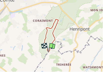
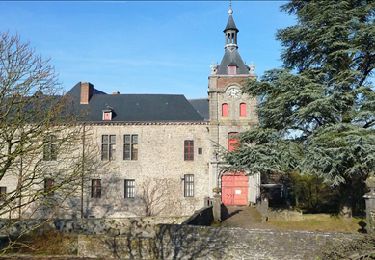
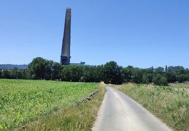
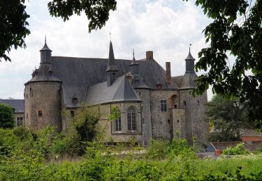
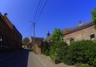
Randonnée Marche de 3,5 km à découvrir à Wallonie, Hainaut, Braine-le-Comte. Cette randonnée est proposée par SandLo.
Description
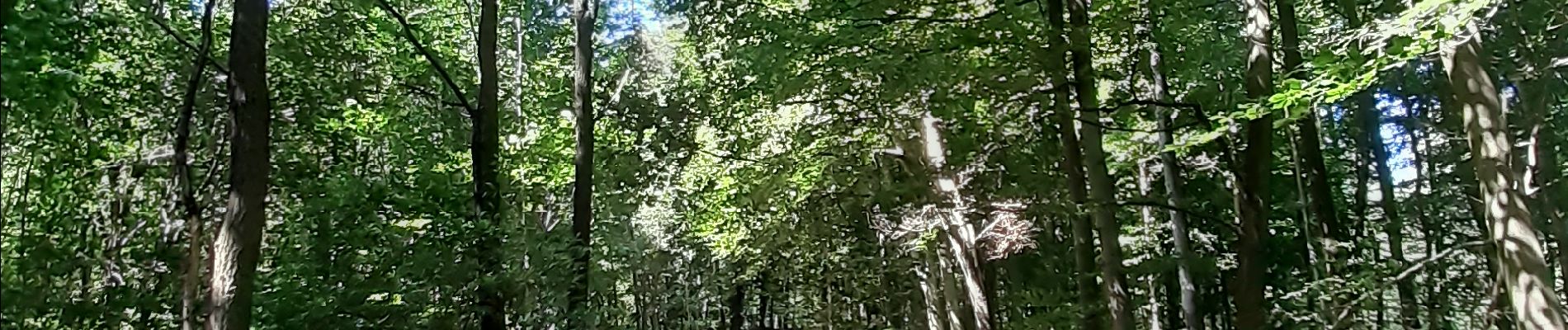
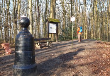
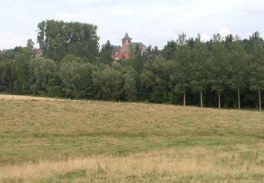
Petite promenade dans le bois près du Bonhomme de Fer. Certains sentiers sont bien cachés. Clairière en fin de parcours pour se poser et écouter les arbres chuchoter.
Localisation
Pays :
Belgique
Région :
Wallonie
Département/Province :
Hainaut
Commune :
Braine-le-Comte
Localité :
Unknown
Départ:(Dec)
Départ:(UTM)
582617 ; 5604953 (31U) N.
Commentaires
Randonnées à proximité
![Randonnée Marche Braine-le-Comte - De Ronquieres vers Fauquez par le bois des Rocs et de la Houssi�re - Photo](https://media.geolcdn.com/t/375/260/ext.jpg?maxdim=2&url=https%3A%2F%2Fstatic1.geolcdn.com%2Fsiteimages%2Fupload%2Ffiles%2F1553511878bg_sport_marche.png)
![Marche Marche](https://static1.geolcdn.com/sitytour/trail-icons/101.png)
De Ronquieres vers Fauquez par le bois des Rocs et de la Houssi�re
Marche
Facile
(9)
Braine-le-Comte,
Wallonie,
Hainaut,
Belgique
![](/images/other/stat-length.png)
8,2 km | 10,5 km-effort
2h 5min
![](https://static1.geolcdn.com/siteimages/upload/files/16400158638029165_repeat_loop_refresh_sync_direction_icon.png)
Oui
![Randonnée Marche Braine-le-Comte - Balade dans la Bois de la Houssière - Henripont - Photo](https://media.geolcdn.com/t/375/260/4fa666cb-ad24-4cad-ab32-8d312d744770.jpg&format=jpg&maxdim=2)
![Marche Marche](https://static1.geolcdn.com/sitytour/trail-icons/101.png)
Balade dans la Bois de la Houssière - Henripont
Marche
Très facile
(3)
Braine-le-Comte,
Wallonie,
Hainaut,
Belgique
![](/images/other/stat-length.png)
9,8 km | 12,1 km-effort
3h 51min
![](https://static1.geolcdn.com/siteimages/upload/files/16400158638029165_repeat_loop_refresh_sync_direction_icon.png)
Oui
![Randonnée Marche Braine-le-Comte - henripont 0815 - Photo](https://media.geolcdn.com/t/375/260/ext.jpg?maxdim=2&url=https%3A%2F%2Fservices.sitytrail.com%2FGeolivesWS%2FDownloadMedia.ashx%3FTrailID%3D459868%26Media%3Df7319801-bb13-46c5-92f4-435aa6f14df6.jpg)
![Marche Marche](https://static1.geolcdn.com/sitytour/trail-icons/101.png)
henripont 0815
Marche
Facile
(2)
Braine-le-Comte,
Wallonie,
Hainaut,
Belgique
![](/images/other/stat-length.png)
5 km | 6,2 km-effort
1h 21min
![](https://static1.geolcdn.com/siteimages/upload/files/16400158638029165_repeat_loop_refresh_sync_direction_icon.png)
Oui
![Randonnée Marche Écaussinnes - Le Val de la Sennette - Photo](https://media.geolcdn.com/t/375/260/ext.jpg?maxdim=2&url=https%3A%2F%2Fservices.sitytrail.com%2FGeolivesWS%2FDownloadMedia.ashx%3FTrailID%3D176271%26Media%3D77a9b41c-694c-4f37-aab7-2d561fd12cc1.jpg)
![Marche Marche](https://static1.geolcdn.com/sitytour/trail-icons/101.png)
Le Val de la Sennette
Marche
Facile
(4)
Écaussinnes,
Wallonie,
Hainaut,
Belgique
![](/images/other/stat-length.png)
6,8 km | 7,7 km-effort
1h 42min
![](https://static1.geolcdn.com/siteimages/upload/files/16400158638029165_repeat_loop_refresh_sync_direction_icon.png)
Oui
![Randonnée V.T.T. Braine-le-Comte - O2bikers_21_Braine_le_comte - Photo](https://media.geolcdn.com/t/375/260/ext.jpg?maxdim=2&url=https%3A%2F%2Fstatic1.geolcdn.com%2Fsiteimages%2Fupload%2Ffiles%2F1524743154velo.jpg)
![V.T.T. V.T.T.](https://static1.geolcdn.com/sitytour/trail-icons/202.png)
O2bikers_21_Braine_le_comte
V.T.T.
Très facile
(4)
Braine-le-Comte,
Wallonie,
Hainaut,
Belgique
![](/images/other/stat-length.png)
17,9 km | 22 km-effort
2h 41min
![](https://static1.geolcdn.com/siteimages/upload/files/16400158638029165_repeat_loop_refresh_sync_direction_icon.png)
Oui
![Randonnée A pied Braine-le-Comte - Adeps 2024 ASBL Amicale Sapeurs Pompiers BLC 25/02/24 5km - Photo](https://media.geolcdn.com/t/375/260/236df6a2-aebb-4695-b4fc-0253cf384198.jpg&format=jpg&maxdim=2)
![A pied A pied](https://static1.geolcdn.com/sitytour/trail-icons/100.png)
Adeps 2024 ASBL Amicale Sapeurs Pompiers BLC 25/02/24 5km
A pied
Facile
(2)
Braine-le-Comte,
Wallonie,
Hainaut,
Belgique
![](/images/other/stat-length.png)
6,4 km | 7,3 km-effort
1h 39min
![](https://static1.geolcdn.com/siteimages/upload/files/16400158638029165_repeat_loop_refresh_sync_direction_icon.png)
Oui
![Randonnée Marche Braine-le-Comte - Promenade des canaux de Ronquières - Photo](https://media.geolcdn.com/t/375/260/721a75b8-7f3c-43cf-a16f-5d92f0a07e91.jpg&format=jpg&maxdim=2)
![Marche Marche](https://static1.geolcdn.com/sitytour/trail-icons/101.png)
Promenade des canaux de Ronquières
Marche
Moyen
(5)
Braine-le-Comte,
Wallonie,
Hainaut,
Belgique
![](/images/other/stat-length.png)
8,4 km | 9,7 km-effort
2h 11min
![](https://static1.geolcdn.com/siteimages/upload/files/16400158638029165_repeat_loop_refresh_sync_direction_icon.png)
Oui
![Randonnée Marche Écaussinnes - Balade à Ecaussinnes - Photo](https://media.geolcdn.com/t/375/260/689a14ba-c9cf-428d-9543-98253b178eb9.jpeg&format=jpg&maxdim=2)
![Marche Marche](https://static1.geolcdn.com/sitytour/trail-icons/101.png)
Balade à Ecaussinnes
Marche
Moyen
(1)
Écaussinnes,
Wallonie,
Hainaut,
Belgique
![](/images/other/stat-length.png)
8,4 km | 9,7 km-effort
2h 11min
![](https://static1.geolcdn.com/siteimages/upload/files/16400158638029165_repeat_loop_refresh_sync_direction_icon.png)
Oui
![V.T.T. V.T.T.](https://static1.geolcdn.com/sitytour/trail-icons/202.png)
VTT autour de Ronquières
V.T.T.
Très difficile
Braine-le-Comte,
Wallonie,
Hainaut,
Belgique
![](/images/other/stat-length.png)
51 km | 60 km-effort
4h 10min
![](https://static1.geolcdn.com/siteimages/upload/files/16400158638029165_repeat_loop_refresh_sync_direction_icon.png)
Oui