![](/images/other/stat-length.png)
![Randonnée Marche Binche - BINCHE _ Marche Fédérale _ HT_ 16/07/2022 - Photo](https://media.geolcdn.com/t/1900/400/e62a8757-e2f6-4362-8289-b9e07357899c.jpg&format=pjpeg&maxdim=2)
BINCHE _ Marche Fédérale _ HT_ 16/07/2022
jeangulu
Utilisateur
![Longueur](/images/other/stat-length.png)
Longueur
17,8 km
![Altitude max](https://static1.geolcdn.com/siteimages/upload/files/1508320355ic_sort_altitude_max_24dp.png)
Altitude max
142 m
![Dénivelé positif](https://static1.geolcdn.com/siteimages/upload/files/1508320355ic_sort_den_pos_24dp.png)
Dénivelé positif
181 m
![Km-Effort](/images/other/stat-length.png)
Km-Effort
20 km
![Altitude min](https://static1.geolcdn.com/siteimages/upload/files/1508320355ic_sort_altitude_min_24dp.png)
Altitude min
61 m
![Dénivelé négatif](https://static1.geolcdn.com/siteimages/upload/files/1508320355ic_sort_den_neg_24dp.png)
Dénivelé négatif
182 m
![Boucle](https://static1.geolcdn.com/siteimages/upload/files/16400158638029165_repeat_loop_refresh_sync_direction_icon.png)
Boucle
Oui
Date de création :
2022-07-16 08:11:49.069
Dernière modification :
2022-07-16 12:41:37.69
![Marche](https://static1.geolcdn.com/sitytour/trail-icons/101.png)
4h28
Difficulté : Facile
![Scannez ce code QR pour ouvrir la randonnée dans l'application SityTrail](https://capi.geolives.com/qq0zvz2zws4bq2lad0pu/sitytour/trails/3318438/qr.png?size=200)
Application GPS de randonnée GRATUITE
À propos
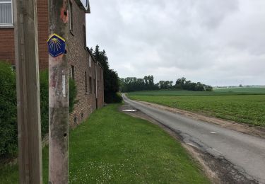
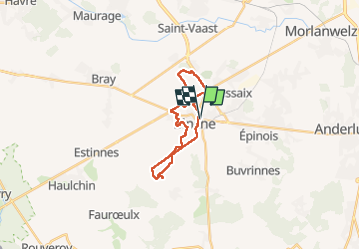
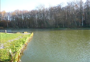
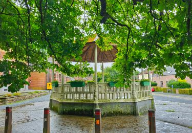
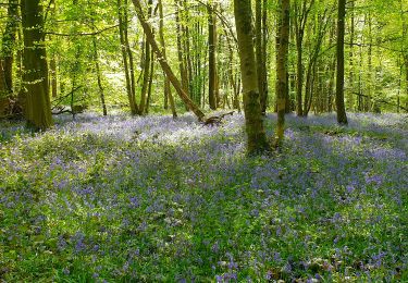
Randonnée Marche de 17,8 km à découvrir à Wallonie, Hainaut, Binche. Cette randonnée est proposée par jeangulu.
Description
Point de départ : Salle du Kursaal - Avenue Wanderpepen, 30 - 7130 BINCHE.
Organisateur : HT 025 - LES MARCHEURS DE LA POLICE DE BINCHE.
Localisation
Pays :
Belgique
Région :
Wallonie
Département/Province :
Hainaut
Commune :
Binche
Localité :
Unknown
Départ:(Dec)
Départ:(UTM)
583074 ; 5585150 (31U) N.
Commentaires
Randonnées à proximité
![Randonnée Marche Lobbes - Balade à Mont-Sainte-Geneviève - Photo](https://media.geolcdn.com/t/375/260/ext.jpg?maxdim=2&url=https%3A%2F%2Fservices.sitytrail.com%2FGeolivesWS%2FDownloadMedia.ashx%3FTrailID%3D378767%26Media%3D9ad7b20e-c031-407f-875d-742351009cf4.jpg)
![Marche Marche](https://static1.geolcdn.com/sitytour/trail-icons/101.png)
Balade à Mont-Sainte-Geneviève
Marche
Très facile
(3)
Lobbes,
Wallonie,
Hainaut,
Belgique
![](/images/other/stat-length.png)
9,1 km | 10,4 km-effort
2h 18min
![](https://static1.geolcdn.com/siteimages/upload/files/16400158638029165_repeat_loop_refresh_sync_direction_icon.png)
Oui
![Randonnée Marche Binche - Les marais de Buvrinnes - Photo](https://media.geolcdn.com/t/375/260/ext.jpg?maxdim=2&url=https%3A%2F%2Fservices.sitytrail.com%2FGeolivesWS%2FDownloadMedia.ashx%3FTrailID%3D308684%26Media%3Dc96914c7-aa42-4b0f-8d11-534a0221fc18.JPG)
![Marche Marche](https://static1.geolcdn.com/sitytour/trail-icons/101.png)
Les marais de Buvrinnes
Marche
Très facile
(2)
Binche,
Wallonie,
Hainaut,
Belgique
![](/images/other/stat-length.png)
4,2 km | 5 km-effort
1h 5min
![](https://static1.geolcdn.com/siteimages/upload/files/16400158638029165_repeat_loop_refresh_sync_direction_icon.png)
Oui
![Randonnée Marche Binche - De Leval-Trahegnies à Mont-Sainte-Aldegonde - Photo](https://media.geolcdn.com/t/375/260/ext.jpg?maxdim=2&url=https%3A%2F%2Fservices.sitytrail.com%2FGeolivesWS%2FDownloadMedia.ashx%3FTrailID%3D96104%26Media%3D21dc5c72-4ff2-4334-88b1-a5c37d1d86a8.JPG)
![Marche Marche](https://static1.geolcdn.com/sitytour/trail-icons/101.png)
De Leval-Trahegnies à Mont-Sainte-Aldegonde
Marche
Facile
(1)
Binche,
Wallonie,
Hainaut,
Belgique
![](/images/other/stat-length.png)
8,8 km | 10,8 km-effort
2h 20min
![](https://static1.geolcdn.com/siteimages/upload/files/16400158638029165_repeat_loop_refresh_sync_direction_icon.png)
Oui
![Randonnée Marche Binche - Balade à Binche - Photo](https://media.geolcdn.com/t/375/260/ext.jpg?maxdim=2&url=https%3A%2F%2Fstatic1.geolcdn.com%2Fsiteimages%2Fupload%2Ffiles%2F1553511878bg_sport_marche.png)
![Marche Marche](https://static1.geolcdn.com/sitytour/trail-icons/101.png)
Balade à Binche
Marche
Moyen
(4)
Binche,
Wallonie,
Hainaut,
Belgique
![](/images/other/stat-length.png)
17,9 km | 21 km-effort
4h 30min
![](https://static1.geolcdn.com/siteimages/upload/files/16400158638029165_repeat_loop_refresh_sync_direction_icon.png)
Oui
![Randonnée Marche nordique Morlanwelz - Mont Sainte Aldegonde 7km - Photo](https://media.geolcdn.com/t/375/260/ext.jpg?maxdim=2&url=https%3A%2F%2Fstatic1.geolcdn.com%2Fsiteimages%2Fupload%2Ffiles%2F1545311037marcheuse_200dpi.jpg)
![Marche nordique Marche nordique](https://static1.geolcdn.com/sitytour/trail-icons/102.png)
Mont Sainte Aldegonde 7km
Marche nordique
Facile
(1)
Morlanwelz,
Wallonie,
Hainaut,
Belgique
![](/images/other/stat-length.png)
7,1 km | 8,2 km-effort
1h 30min
![](https://static1.geolcdn.com/siteimages/upload/files/16400158638029165_repeat_loop_refresh_sync_direction_icon.png)
Oui
![Randonnée Marche Lobbes - Balade à Mont-Sainte-Geneviève - Photo](https://media.geolcdn.com/t/375/260/3e6cb871-d675-45b6-b039-eefee51e193b.jpeg&format=jpg&maxdim=2)
![Marche Marche](https://static1.geolcdn.com/sitytour/trail-icons/101.png)
Balade à Mont-Sainte-Geneviève
Marche
Moyen
(1)
Lobbes,
Wallonie,
Hainaut,
Belgique
![](/images/other/stat-length.png)
10,5 km | 11,8 km-effort
3h 11min
![](https://static1.geolcdn.com/siteimages/upload/files/16400158638029165_repeat_loop_refresh_sync_direction_icon.png)
Oui
![Randonnée Marche Lobbes - Balade à Mont-Sainte-Geneviève - Photo](https://media.geolcdn.com/t/375/260/bca4789a-9723-4611-bdb6-0d9835beb766.jpg&format=jpg&maxdim=2)
![Marche Marche](https://static1.geolcdn.com/sitytour/trail-icons/101.png)
Balade à Mont-Sainte-Geneviève
Marche
Moyen
Lobbes,
Wallonie,
Hainaut,
Belgique
![](/images/other/stat-length.png)
9,9 km | 11,8 km-effort
2h 40min
![](https://static1.geolcdn.com/siteimages/upload/files/16400158638029165_repeat_loop_refresh_sync_direction_icon.png)
Oui
![Randonnée Marche Binche - Autour du marais de Buvrinnes - Photo](https://media.geolcdn.com/t/375/260/ext.jpg?maxdim=2&url=https%3A%2F%2Fstatic1.geolcdn.com%2Fsiteimages%2Fupload%2Ffiles%2F1553511878bg_sport_marche.png)
![Marche Marche](https://static1.geolcdn.com/sitytour/trail-icons/101.png)
Autour du marais de Buvrinnes
Marche
Facile
(1)
Binche,
Wallonie,
Hainaut,
Belgique
![](/images/other/stat-length.png)
4,2 km | 5 km-effort
1h 8min
![](https://static1.geolcdn.com/siteimages/upload/files/16400158638029165_repeat_loop_refresh_sync_direction_icon.png)
Oui
![Randonnée Marche Binche - Binche 20 km - Photo](https://media.geolcdn.com/t/375/260/1841b57f-6493-467c-87bb-7bd139775c50.jpg&format=jpg&maxdim=2)
![Marche Marche](https://static1.geolcdn.com/sitytour/trail-icons/101.png)