![](/images/other/stat-length.png)
![Randonnée V.T.T. Villards-d'Héria - Villards-D'heriat - le grand lac des Ronchaux - Photo](https://media.geolcdn.com/t/1900/400/ext.pjpeg?maxdim=2&url=https%3A%2F%2Fstatic1.geolcdn.com%2Fsiteimages%2Fupload%2Ffiles%2F1524743154velo.jpg)
Villards-D'heriat - le grand lac des Ronchaux
jm.lemore
Utilisateur
![Longueur](/images/other/stat-length.png)
Longueur
39 km
![Altitude max](https://static1.geolcdn.com/siteimages/upload/files/1508320355ic_sort_altitude_max_24dp.png)
Altitude max
1017 m
![Dénivelé positif](https://static1.geolcdn.com/siteimages/upload/files/1508320355ic_sort_den_pos_24dp.png)
Dénivelé positif
907 m
![Km-Effort](/images/other/stat-length.png)
Km-Effort
51 km
![Altitude min](https://static1.geolcdn.com/siteimages/upload/files/1508320355ic_sort_altitude_min_24dp.png)
Altitude min
636 m
![Dénivelé négatif](https://static1.geolcdn.com/siteimages/upload/files/1508320355ic_sort_den_neg_24dp.png)
Dénivelé négatif
912 m
![Boucle](https://static1.geolcdn.com/siteimages/upload/files/16400158638029165_repeat_loop_refresh_sync_direction_icon.png)
Boucle
Oui
Date de création :
2022-07-15 07:41:57.974
Dernière modification :
2022-07-15 11:19:05.341
![V.T.T.](https://static1.geolcdn.com/sitytour/trail-icons/202.png)
2h45
Difficulté : Difficile
![Scannez ce code QR pour ouvrir la randonnée dans l'application SityTrail](https://capi.geolives.com/qq0zvz2zws4bq2lad0pu/sitytour/trails/3317309/qr.png?size=200)
Application GPS de randonnée GRATUITE
À propos
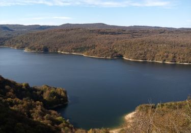
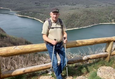
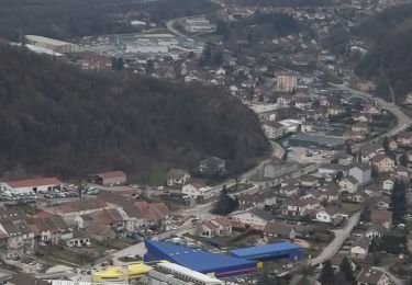
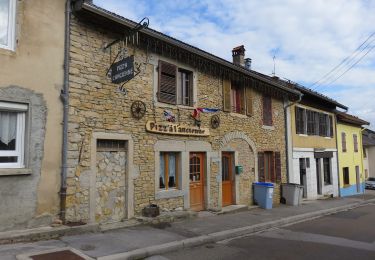
Randonnée V.T.T. de 39 km à découvrir à Bourgogne-Franche-Comté, Jura, Villards-d'Héria. Cette randonnée est proposée par jm.lemore.
Description
en VTTAE , boucle absolument magnifique. Roulant, très varié, tout type de terrain, superbes paysages...
l'arrivée se fait par un superbe single joueur et un peu technique.
déconseillé aux débutants, mais pas très difficile.
Localisation
Pays :
France
Région :
Bourgogne-Franche-Comté
Département/Province :
Jura
Commune :
Villards-d'Héria
Localité :
Unknown
Départ:(Dec)
Départ:(UTM)
710654 ; 5144652 (31T) N.
Commentaires
Randonnées à proximité
![Randonnée Marche Moirans-en-Montagne - Le Regardoir - Photo](https://media.geolcdn.com/t/375/260/2e2d2c64-b4bd-48ba-80a1-644324bc25bf.jpg&format=jpg&maxdim=2)
![Marche Marche](https://static1.geolcdn.com/sitytour/trail-icons/101.png)
Le Regardoir
Marche
Facile
Moirans-en-Montagne,
Bourgogne-Franche-Comté,
Jura,
France
![](/images/other/stat-length.png)
6,8 km | 10,3 km-effort
2h 21min
![](https://static1.geolcdn.com/siteimages/upload/files/16400158638029165_repeat_loop_refresh_sync_direction_icon.png)
Oui
![Randonnée Marche Martigna - rando a martgna dans le jura - Photo](https://media.geolcdn.com/t/375/260/6b33a252-c3e7-4c5b-8119-3accb2705ee1.jpg&format=jpg&maxdim=2)
![Marche Marche](https://static1.geolcdn.com/sitytour/trail-icons/101.png)
rando a martgna dans le jura
Marche
Facile
Martigna,
Bourgogne-Franche-Comté,
Jura,
France
![](/images/other/stat-length.png)
13,8 km | 18,3 km-effort
5h 7min
![](https://static1.geolcdn.com/siteimages/upload/files/16400158638029165_repeat_loop_refresh_sync_direction_icon.png)
Oui
![Randonnée Marche Villards-d'Héria - Villard La vierge Tête d'Henri IV - Photo](https://media.geolcdn.com/t/375/260/bbf39f0f-4e97-453a-9b61-f28b822d2e71.jpg&format=jpg&maxdim=2)
![Marche Marche](https://static1.geolcdn.com/sitytour/trail-icons/101.png)
Villard La vierge Tête d'Henri IV
Marche
Très difficile
Villards-d'Héria,
Bourgogne-Franche-Comté,
Jura,
France
![](/images/other/stat-length.png)
9,5 km | 14,6 km-effort
2h 41min
![](https://static1.geolcdn.com/siteimages/upload/files/16400158638029165_repeat_loop_refresh_sync_direction_icon.png)
Oui
![Randonnée A pied Coteaux du Lizon - Sentier des savoir-faire - Photo](https://media.geolcdn.com/t/375/260/5e891745-52e2-4c86-82b9-36da00a76ac0.jpeg&format=jpg&maxdim=2)
![A pied A pied](https://static1.geolcdn.com/sitytour/trail-icons/100.png)
Sentier des savoir-faire
A pied
Facile
Coteaux du Lizon,
Bourgogne-Franche-Comté,
Jura,
France
![](/images/other/stat-length.png)
3,1 km | 3,9 km-effort
52min
![](https://static1.geolcdn.com/siteimages/upload/files/16400158638029165_repeat_loop_refresh_sync_direction_icon.png)
Oui
![Randonnée Marche Coteaux du Lizon - Vallée du Lison - Photo](https://media.geolcdn.com/t/375/260/ext.jpg?maxdim=2&url=https%3A%2F%2Fstatic1.geolcdn.com%2Fsiteimages%2Fupload%2Ffiles%2F1553511878bg_sport_marche.png)
![Marche Marche](https://static1.geolcdn.com/sitytour/trail-icons/101.png)
Vallée du Lison
Marche
Facile
(1)
Coteaux du Lizon,
Bourgogne-Franche-Comté,
Jura,
France
![](/images/other/stat-length.png)
13,1 km | 18,7 km-effort
3h 50min
![](https://static1.geolcdn.com/siteimages/upload/files/16400158638029165_repeat_loop_refresh_sync_direction_icon.png)
Oui
![Randonnée Randonnée équestre Moirans-en-Montagne - Jura_moirans_J1 - Photo](https://media.geolcdn.com/t/375/260/ext.jpg?maxdim=2&url=https%3A%2F%2Fstatic1.geolcdn.com%2Fsiteimages%2Fupload%2Ffiles%2F1524743154cheval.jpg)
![Randonnée équestre Randonnée équestre](https://static1.geolcdn.com/sitytour/trail-icons/301.png)
Jura_moirans_J1
Randonnée équestre
Moyen
(1)
Moirans-en-Montagne,
Bourgogne-Franche-Comté,
Jura,
France
![](/images/other/stat-length.png)
22 km | 27 km-effort
3h 22min
![](https://static1.geolcdn.com/siteimages/upload/files/16400158638029165_repeat_loop_refresh_sync_direction_icon.png)
Oui
![Randonnée Marche Coteaux du Lizon - gorges du Lison . départ de Saint lupicin - Photo](https://media.geolcdn.com/t/375/260/286e2e3c-117d-4fdc-a219-2e81e971f03b.jpg&format=jpg&maxdim=2)
![Marche Marche](https://static1.geolcdn.com/sitytour/trail-icons/101.png)
gorges du Lison . départ de Saint lupicin
Marche
Moyen
Coteaux du Lizon,
Bourgogne-Franche-Comté,
Jura,
France
![](/images/other/stat-length.png)
18 km | 26 km-effort
5h 55min
![](https://static1.geolcdn.com/siteimages/upload/files/16400158638029165_repeat_loop_refresh_sync_direction_icon.png)
Non
![Randonnée Marche Villards-d'Héria - lac d'Antre Belvédère de Scia - Photo](https://media.geolcdn.com/t/375/260/6cd2b4bc-9d84-4485-b770-90954281a052.jpg&format=jpg&maxdim=2)
![Marche Marche](https://static1.geolcdn.com/sitytour/trail-icons/101.png)
lac d'Antre Belvédère de Scia
Marche
Facile
(1)
Villards-d'Héria,
Bourgogne-Franche-Comté,
Jura,
France
![](/images/other/stat-length.png)
12,5 km | 17,3 km-effort
2h 34min
![](https://static1.geolcdn.com/siteimages/upload/files/16400158638029165_repeat_loop_refresh_sync_direction_icon.png)
Oui
![Randonnée Marche Villards-d'Héria - lac d antre - Photo](https://media.geolcdn.com/t/375/260/80be7616-6067-46a5-8c84-8aeff2838ece.jpg&format=jpg&maxdim=2)
![Marche Marche](https://static1.geolcdn.com/sitytour/trail-icons/101.png)
lac d antre
Marche
Très facile
Villards-d'Héria,
Bourgogne-Franche-Comté,
Jura,
France
![](/images/other/stat-length.png)
7,6 km | 10,4 km-effort
2h 55min
![](https://static1.geolcdn.com/siteimages/upload/files/16400158638029165_repeat_loop_refresh_sync_direction_icon.png)
Oui