![](/images/other/stat-length.png)
![Randonnée Marche Philippeville - Balade de Sart en Fagne à Merlemont - Photo](https://media.geolcdn.com/t/1900/400/5ad4870b-5a8c-462b-8442-a084db46e690.jpg&format=pjpeg&maxdim=2)
Balade de Sart en Fagne à Merlemont
Desrumaux
Utilisateur GUIDE
![Longueur](/images/other/stat-length.png)
![Altitude max](https://static1.geolcdn.com/siteimages/upload/files/1508320355ic_sort_altitude_max_24dp.png)
![Dénivelé positif](https://static1.geolcdn.com/siteimages/upload/files/1508320355ic_sort_den_pos_24dp.png)
![Km-Effort](/images/other/stat-length.png)
![Altitude min](https://static1.geolcdn.com/siteimages/upload/files/1508320355ic_sort_altitude_min_24dp.png)
![Dénivelé négatif](https://static1.geolcdn.com/siteimages/upload/files/1508320355ic_sort_den_neg_24dp.png)
![Boucle](https://static1.geolcdn.com/siteimages/upload/files/16400158638029165_repeat_loop_refresh_sync_direction_icon.png)
![Marche](https://static1.geolcdn.com/sitytour/trail-icons/101.png)
3h00
Difficulté : Facile
![Scannez ce code QR pour ouvrir la randonnée dans l'application SityTrail](https://capi.geolives.com/qq0zvz2zws4bq2lad0pu/sitytour/trails/331315/qr.png?size=200)
Application GPS de randonnée GRATUITE
À propos
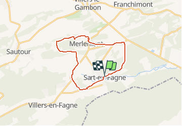
Randonnée Marche de 11 km à découvrir à Wallonie, Namur, Philippeville. Cette randonnée est proposée par Desrumaux.
Description
Agréable balade dans la belle région de la fagne de l'Entre-Sambre et Meuse.
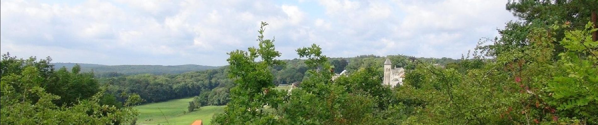
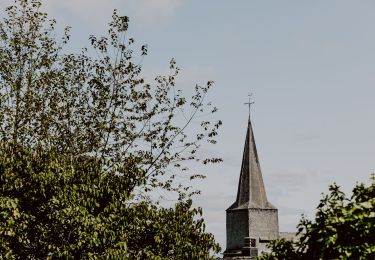
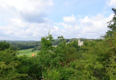
Le village de MERLEMONT est étiré au sommet d'un promontoire et sur le versant sud de celui-ci. L'extrémité Ouest du village est occupée par le château et son parc.
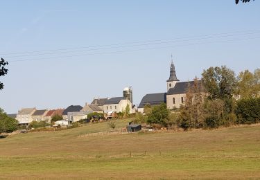
Le petit village de Sart-en-Fagne est étiré au fond de la vallée verdoyante de l'Hermeton et sur le versant exposé au sud.
Localisation
Commentaires
Randonnées à proximité
![Randonnée Marche Philippeville - Balade a Franchimont - Photo](https://media.geolcdn.com/t/375/260/ext.jpg?maxdim=2&url=https%3A%2F%2Fservices.sitytrail.com%2FGeolivesWS%2FDownloadMedia.ashx%3FTrailID%3D1022738%26Media%3D20180815124535.jpg)
![Marche Marche](https://static1.geolcdn.com/sitytour/trail-icons/101.png)
Marche
![](/images/other/stat-length.png)
![](https://static1.geolcdn.com/siteimages/upload/files/16400158638029165_repeat_loop_refresh_sync_direction_icon.png)
![Randonnée Marche Philippeville - Adeps 8 septembre 20 km - Photo](https://media.geolcdn.com/t/375/260/525845c1-8efd-470e-baae-011ed1400759.jpg&format=jpg&maxdim=2)
![Marche Marche](https://static1.geolcdn.com/sitytour/trail-icons/101.png)
Marche
![](/images/other/stat-length.png)
![](https://static1.geolcdn.com/siteimages/upload/files/16400158638029165_repeat_loop_refresh_sync_direction_icon.png)
![Randonnée Marche Philippeville - Balade de Villers-le-Gambon à Franchimont - Photo](https://media.geolcdn.com/t/375/260/68d8ff4d-3e28-466a-b170-34b2b6b08526.jpeg&format=jpg&maxdim=2)
![Marche Marche](https://static1.geolcdn.com/sitytour/trail-icons/101.png)
Marche
![](/images/other/stat-length.png)
![](https://static1.geolcdn.com/siteimages/upload/files/16400158638029165_repeat_loop_refresh_sync_direction_icon.png)
![Randonnée V.T.T. Philippeville - Circuit des Points de Vue - Photo](https://media.geolcdn.com/t/375/260/ext.jpg?maxdim=2&url=https%3A%2F%2Fpivotmedia.tourismewallonie.be%2FOTH-A0-004E-3OY8%2FOTH-A0-004E-3OY8.jpg)
![V.T.T. V.T.T.](https://static1.geolcdn.com/sitytour/trail-icons/202.png)
V.T.T.
![](/images/other/stat-length.png)
![](https://static1.geolcdn.com/siteimages/upload/files/16400158638029165_repeat_loop_refresh_sync_direction_icon.png)
![Randonnée Marche Doische - Balade à Romerée - Photo](https://media.geolcdn.com/t/375/260/2ae8437e-ab4f-4ffe-bd73-4279db504da4.jpg&format=jpg&maxdim=2)
![Marche Marche](https://static1.geolcdn.com/sitytour/trail-icons/101.png)
![Randonnée Marche Doische - Balade à Matagne-la-Grande - Photo](https://media.geolcdn.com/t/375/260/067d5ece-ec35-4d28-bd0e-2f8ad16c5e7a.jpg&format=jpg&maxdim=2)
![Marche Marche](https://static1.geolcdn.com/sitytour/trail-icons/101.png)
Marche
![](/images/other/stat-length.png)
![](https://static1.geolcdn.com/siteimages/upload/files/16400158638029165_repeat_loop_refresh_sync_direction_icon.png)
![Randonnée Marche Doische - Balade à Matagne-la-Petite - Photo](https://media.geolcdn.com/t/375/260/7778bbe7-de3b-4abe-ae45-2a9d4386675d.jpeg&format=jpg&maxdim=2)
![Marche Marche](https://static1.geolcdn.com/sitytour/trail-icons/101.png)
Marche
![](/images/other/stat-length.png)
![](https://static1.geolcdn.com/siteimages/upload/files/16400158638029165_repeat_loop_refresh_sync_direction_icon.png)
![Randonnée Marche Philippeville - 8 septembre, Adeps 15 km - Photo](https://media.geolcdn.com/t/375/260/ext.jpg?maxdim=2&url=https%3A%2F%2Fstatic1.geolcdn.com%2Fsiteimages%2Fupload%2Ffiles%2F1553511878bg_sport_marche.png)
![Marche Marche](https://static1.geolcdn.com/sitytour/trail-icons/101.png)
Marche
![](/images/other/stat-length.png)
![](https://static1.geolcdn.com/siteimages/upload/files/16400158638029165_repeat_loop_refresh_sync_direction_icon.png)
![Randonnée Marche Philippeville - De Merlemont à Sart-en-Fagne - Photo](https://media.geolcdn.com/t/375/260/ext.jpg?maxdim=2&url=https%3A%2F%2Fservices.sitytrail.com%2FGeolivesWS%2FDownloadMedia.ashx%3FTrailID%3D338933%26Media%3D94ce6f23-1cb2-4922-9457-681730304876.JPG)
![Marche Marche](https://static1.geolcdn.com/sitytour/trail-icons/101.png)
Marche
![](/images/other/stat-length.png)
![](https://static1.geolcdn.com/siteimages/upload/files/16400158638029165_repeat_loop_refresh_sync_direction_icon.png)
81.562