![](/images/other/stat-length.png)
![Randonnée Marche Abriès-Ristolas - lac Lestio - Photo](https://media.geolcdn.com/t/1900/400/ext.pjpeg?maxdim=2&url=https%3A%2F%2Fstatic1.geolcdn.com%2Fsiteimages%2Fupload%2Ffiles%2F1553511878bg_sport_marche.png)
lac Lestio
stelh
Utilisateur
![Longueur](/images/other/stat-length.png)
Longueur
19,2 km
![Altitude max](https://static1.geolcdn.com/siteimages/upload/files/1508320355ic_sort_altitude_max_24dp.png)
Altitude max
2515 m
![Dénivelé positif](https://static1.geolcdn.com/siteimages/upload/files/1508320355ic_sort_den_pos_24dp.png)
Dénivelé positif
797 m
![Km-Effort](/images/other/stat-length.png)
Km-Effort
30 km
![Altitude min](https://static1.geolcdn.com/siteimages/upload/files/1508320355ic_sort_altitude_min_24dp.png)
Altitude min
1792 m
![Dénivelé négatif](https://static1.geolcdn.com/siteimages/upload/files/1508320355ic_sort_den_neg_24dp.png)
Dénivelé négatif
794 m
![Boucle](https://static1.geolcdn.com/siteimages/upload/files/16400158638029165_repeat_loop_refresh_sync_direction_icon.png)
Boucle
Oui
Date de création :
2014-12-10 00:00:00.0
Dernière modification :
2014-12-10 00:00:00.0
![Marche](https://static1.geolcdn.com/sitytour/trail-icons/101.png)
6h12
Difficulté : Difficile
![Scannez ce code QR pour ouvrir la randonnée dans l'application SityTrail](https://capi.geolives.com/qq0zvz2zws4bq2lad0pu/sitytour/trails/330960/qr.png?size=200)
Application GPS de randonnée GRATUITE
À propos
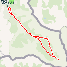
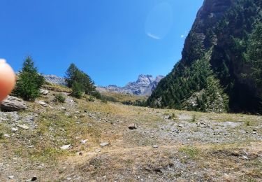
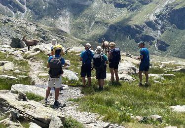
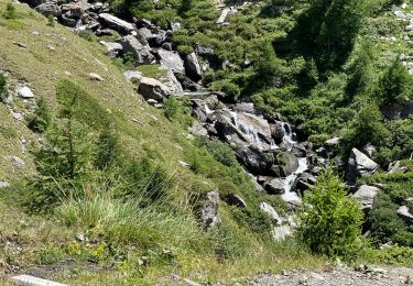
Randonnée Marche de 19,2 km à découvrir à Provence-Alpes-Côte d'Azur, Hautes-Alpes, Abriès-Ristolas. Cette randonnée est proposée par stelh.
Description
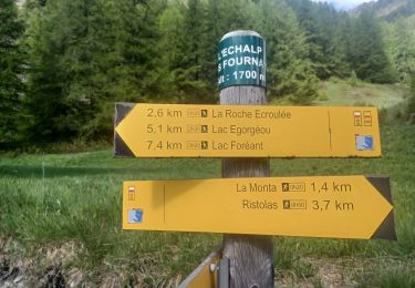
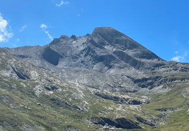
Très jolie rando de la roche écroulée (ristolas) jusqu'aux sources du Guil, le lac Lestio, dominé par le Mont Viso. Aucune difficulté technique mais la rando est longue, et superbe !
Localisation
Pays :
France
Région :
Provence-Alpes-Côte d'Azur
Département/Province :
Hautes-Alpes
Commune :
Abriès-Ristolas
Localité :
Ristolas
Départ:(Dec)
Départ:(UTM)
341404 ; 4955608 (32T) N.
Commentaires
Randonnées à proximité
![Randonnée Marche Abriès-Ristolas - ABRIES .ECHÀLP. RISTOLAS.LAC EGORGEOU . BOUQUETINS O - Photo](https://media.geolcdn.com/t/375/260/0b5f13ba-92f4-44de-8892-1b1bd667648a.jpg&format=jpg&maxdim=2)
![Marche Marche](https://static1.geolcdn.com/sitytour/trail-icons/101.png)
ABRIES .ECHÀLP. RISTOLAS.LAC EGORGEOU . BOUQUETINS O
Marche
Difficile
Abriès-Ristolas,
Provence-Alpes-Côte d'Azur,
Hautes-Alpes,
France
![](/images/other/stat-length.png)
9,3 km | 14,5 km-effort
3h 1min
![](https://static1.geolcdn.com/siteimages/upload/files/16400158638029165_repeat_loop_refresh_sync_direction_icon.png)
Oui
![Randonnée Marche Abriès-Ristolas - l echalp, la montat - Photo](https://media.geolcdn.com/t/375/260/987318c0-4e03-46ad-a735-99dd4d7908e8.jpg&format=jpg&maxdim=2)
![Marche Marche](https://static1.geolcdn.com/sitytour/trail-icons/101.png)
l echalp, la montat
Marche
Difficile
Abriès-Ristolas,
Provence-Alpes-Côte d'Azur,
Hautes-Alpes,
France
![](/images/other/stat-length.png)
9,4 km | 18,1 km-effort
4h 51min
![](https://static1.geolcdn.com/siteimages/upload/files/16400158638029165_repeat_loop_refresh_sync_direction_icon.png)
Oui
![Randonnée Marche Abriès-Ristolas - Queyras 08 - Ristolas - Abriès - Photo](https://media.geolcdn.com/t/375/260/8f39446e-4ab6-4158-b028-124d8ed0f858.jpg&format=jpg&maxdim=2)
![Marche Marche](https://static1.geolcdn.com/sitytour/trail-icons/101.png)
Queyras 08 - Ristolas - Abriès
Marche
Très difficile
Abriès-Ristolas,
Provence-Alpes-Côte d'Azur,
Hautes-Alpes,
France
![](/images/other/stat-length.png)
16,5 km | 28 km-effort
8h 2min
![](https://static1.geolcdn.com/siteimages/upload/files/16400158638029165_repeat_loop_refresh_sync_direction_icon.png)
Non
![Randonnée Marche Abriès-Ristolas - Belvédère du Viso - Photo](https://media.geolcdn.com/t/375/260/215f9969-2f60-45f2-92b4-9879664eb7b5.jpg&format=jpg&maxdim=2)
![Marche Marche](https://static1.geolcdn.com/sitytour/trail-icons/101.png)
Belvédère du Viso
Marche
Moyen
Abriès-Ristolas,
Provence-Alpes-Côte d'Azur,
Hautes-Alpes,
France
![](/images/other/stat-length.png)
8,9 km | 12,6 km-effort
2h 27min
![](https://static1.geolcdn.com/siteimages/upload/files/16400158638029165_repeat_loop_refresh_sync_direction_icon.png)
Non
![Randonnée Marche Abriès-Ristolas - Lacroix - Photo](https://media.geolcdn.com/t/375/260/d76ef24d-da62-43ec-9b27-b9679d8c5917.jpg&format=jpg&maxdim=2)
![Marche Marche](https://static1.geolcdn.com/sitytour/trail-icons/101.png)
Lacroix
Marche
Très difficile
Abriès-Ristolas,
Provence-Alpes-Côte d'Azur,
Hautes-Alpes,
France
![](/images/other/stat-length.png)
9,4 km | 22 km-effort
2h 57min
![](https://static1.geolcdn.com/siteimages/upload/files/16400158638029165_repeat_loop_refresh_sync_direction_icon.png)
Oui
![Randonnée Marche Abriès-Ristolas - J11 Queyras 2022 - Photo](https://media.geolcdn.com/t/375/260/bc59477d-5047-48dc-945b-6313b3c2a7b5.jpg&format=jpg&maxdim=2)
![Marche Marche](https://static1.geolcdn.com/sitytour/trail-icons/101.png)
J11 Queyras 2022
Marche
Moyen
Abriès-Ristolas,
Provence-Alpes-Côte d'Azur,
Hautes-Alpes,
France
![](/images/other/stat-length.png)
9,8 km | 22 km-effort
2h 56min
![](https://static1.geolcdn.com/siteimages/upload/files/16400158638029165_repeat_loop_refresh_sync_direction_icon.png)
Oui
![Randonnée Marche Abriès-Ristolas - J10 Queyras 2022 - Photo](https://media.geolcdn.com/t/375/260/6b1abaf5-e070-41a7-b2a8-0b5f74371fc6.jpg&format=jpg&maxdim=2)
![Marche Marche](https://static1.geolcdn.com/sitytour/trail-icons/101.png)
J10 Queyras 2022
Marche
Très difficile
Abriès-Ristolas,
Provence-Alpes-Côte d'Azur,
Hautes-Alpes,
France
![](/images/other/stat-length.png)
22 km | 42 km-effort
6h 12min
![](https://static1.geolcdn.com/siteimages/upload/files/16400158638029165_repeat_loop_refresh_sync_direction_icon.png)
Oui
![Randonnée Marche Abriès-Ristolas - Traversette - Photo](https://media.geolcdn.com/t/375/260/461e073d-5f42-4e6f-bff2-3ae371f6584e.jpg&format=jpg&maxdim=2)
![Marche Marche](https://static1.geolcdn.com/sitytour/trail-icons/101.png)
Traversette
Marche
Très difficile
Abriès-Ristolas,
Provence-Alpes-Côte d'Azur,
Hautes-Alpes,
France
![](/images/other/stat-length.png)
18,7 km | 35 km-effort
5h 32min
![](https://static1.geolcdn.com/siteimages/upload/files/16400158638029165_repeat_loop_refresh_sync_direction_icon.png)
Oui
![Randonnée Marche Abriès-Ristolas - J8 Queyras 2022 - Photo](https://media.geolcdn.com/t/375/260/c2a72883-6d45-43df-9b33-1f5e20773017.jpg&format=jpg&maxdim=2)
![Marche Marche](https://static1.geolcdn.com/sitytour/trail-icons/101.png)
J8 Queyras 2022
Marche
Difficile
Abriès-Ristolas,
Provence-Alpes-Côte d'Azur,
Hautes-Alpes,
France
![](/images/other/stat-length.png)
19,4 km | 36 km-effort
5h 17min
![](https://static1.geolcdn.com/siteimages/upload/files/16400158638029165_repeat_loop_refresh_sync_direction_icon.png)
Oui
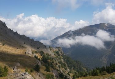
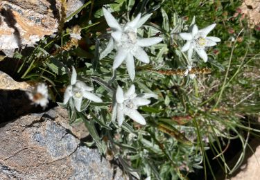
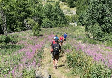
Magnifique randonnée avec vues superbes