![](/images/other/stat-length.png)
![Randonnée Marche Chalmazel-Jeansagnière - 220623-StJean.Vetre- Sapeau-Colombier - Photo](https://media.geolcdn.com/t/1900/400/ext.pjpeg?maxdim=2&url=https%3A%2F%2Fstatic1.geolcdn.com%2Fsiteimages%2Fupload%2Ffiles%2F1553511878bg_sport_marche.png)
220623-StJean.Vetre- Sapeau-Colombier
randodan
Utilisateur
![Longueur](/images/other/stat-length.png)
Longueur
6,7 km
![Altitude max](https://static1.geolcdn.com/siteimages/upload/files/1508320355ic_sort_altitude_max_24dp.png)
Altitude max
1226 m
![Dénivelé positif](https://static1.geolcdn.com/siteimages/upload/files/1508320355ic_sort_den_pos_24dp.png)
Dénivelé positif
207 m
![Km-Effort](/images/other/stat-length.png)
Km-Effort
9,5 km
![Altitude min](https://static1.geolcdn.com/siteimages/upload/files/1508320355ic_sort_altitude_min_24dp.png)
Altitude min
1096 m
![Dénivelé négatif](https://static1.geolcdn.com/siteimages/upload/files/1508320355ic_sort_den_neg_24dp.png)
Dénivelé négatif
207 m
![Boucle](https://static1.geolcdn.com/siteimages/upload/files/16400158638029165_repeat_loop_refresh_sync_direction_icon.png)
Boucle
Oui
Date de création :
2022-06-21 20:40:50.838
Dernière modification :
2022-06-24 21:10:20.255
![Marche](https://static1.geolcdn.com/sitytour/trail-icons/101.png)
2h09
Difficulté : Moyen
![Scannez ce code QR pour ouvrir la randonnée dans l'application SityTrail](https://capi.geolives.com/qq0zvz2zws4bq2lad0pu/sitytour/trails/3290592/qr.png?size=200)
Application GPS de randonnée GRATUITE
À propos
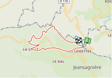
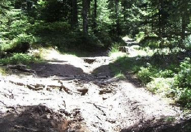
Randonnée Marche de 6,7 km à découvrir à Auvergne-Rhône-Alpes, Loire, Chalmazel-Jeansagnière. Cette randonnée est proposée par randodan.
Description
Préparation utilisée à la place, en guise de tracé, car BIG PB appli/portable (carte tournante, arrêt intempestif enregistrement).
Avons pris raccourci PAS marqué sur IGN !!!!!!!!!!!!!!!!!!!!!!!!!!!
Localisation
Pays :
France
Région :
Auvergne-Rhône-Alpes
Département/Province :
Loire
Commune :
Chalmazel-Jeansagnière
Localité :
Jeansagnière
Départ:(Dec)
Départ:(UTM)
564894 ; 5065569 (31T) N.
Commentaires
Randonnées à proximité
![Randonnée Marche Chalmazel-Jeansagnière - Au dessus de Chalmazel - Photo](https://media.geolcdn.com/t/375/260/25e3078d-228b-4291-af75-c67ea03e26dc.jpg&format=jpg&maxdim=2)
![Marche Marche](https://static1.geolcdn.com/sitytour/trail-icons/101.png)
Au dessus de Chalmazel
Marche
Moyen
Chalmazel-Jeansagnière,
Auvergne-Rhône-Alpes,
Loire,
France
![](/images/other/stat-length.png)
18,4 km | 27 km-effort
4h 25min
![](https://static1.geolcdn.com/siteimages/upload/files/16400158638029165_repeat_loop_refresh_sync_direction_icon.png)
Oui
![Randonnée V.T.T. Saint-Didier-sur-Rochefort - La Brosse Jour 3 - Photo](https://media.geolcdn.com/t/375/260/ext.jpg?maxdim=2&url=https%3A%2F%2Fstatic1.geolcdn.com%2Fsiteimages%2Fupload%2Ffiles%2F1524743154velo.jpg)
![V.T.T. V.T.T.](https://static1.geolcdn.com/sitytour/trail-icons/202.png)
La Brosse Jour 3
V.T.T.
Moyen
(1)
Saint-Didier-sur-Rochefort,
Auvergne-Rhône-Alpes,
Loire,
France
![](/images/other/stat-length.png)
26 km | 36 km-effort
2h 28min
![](https://static1.geolcdn.com/siteimages/upload/files/16400158638029165_repeat_loop_refresh_sync_direction_icon.png)
Oui
![Randonnée Cheval La Chambonie - Chalmazel J1 PV Col de la loge -Ganier J0-J1 - Photo](https://media.geolcdn.com/t/375/260/ext.jpg?maxdim=2&url=https%3A%2F%2Fstatic1.geolcdn.com%2Fsiteimages%2Fupload%2Ffiles%2F1524743154cheval.jpg)
![Cheval Cheval](https://static1.geolcdn.com/sitytour/trail-icons/300.png)
Chalmazel J1 PV Col de la loge -Ganier J0-J1
Cheval
Moyen
(1)
La Chambonie,
Auvergne-Rhône-Alpes,
Loire,
France
![](/images/other/stat-length.png)
27 km | 38 km-effort
4h 33min
![](https://static1.geolcdn.com/siteimages/upload/files/16400158638029165_repeat_loop_refresh_sync_direction_icon.png)
Non
![Randonnée Cheval Chalmazel-Jeansagnière - Chalmazel J3 Boucle col de la loge J3 - Photo](https://media.geolcdn.com/t/375/260/ext.jpg?maxdim=2&url=https%3A%2F%2Fstatic1.geolcdn.com%2Fsiteimages%2Fupload%2Ffiles%2F1524743154cheval.jpg)
![Cheval Cheval](https://static1.geolcdn.com/sitytour/trail-icons/300.png)
Chalmazel J3 Boucle col de la loge J3
Cheval
Moyen
(1)
Chalmazel-Jeansagnière,
Auvergne-Rhône-Alpes,
Loire,
France
![](/images/other/stat-length.png)
30 km | 43 km-effort
5h 9min
![](https://static1.geolcdn.com/siteimages/upload/files/16400158638029165_repeat_loop_refresh_sync_direction_icon.png)
Oui
![Randonnée Marche Chalmazel-Jeansagnière - col de la loge 9,5 km - Photo](https://media.geolcdn.com/t/375/260/8b29fd94-7bd8-47d5-b069-74d6e8f3bbda.jpg&format=jpg&maxdim=2)
![Marche Marche](https://static1.geolcdn.com/sitytour/trail-icons/101.png)
col de la loge 9,5 km
Marche
Moyen
Chalmazel-Jeansagnière,
Auvergne-Rhône-Alpes,
Loire,
France
![](/images/other/stat-length.png)
9,4 km | 11,8 km-effort
2h 41min
![](https://static1.geolcdn.com/siteimages/upload/files/16400158638029165_repeat_loop_refresh_sync_direction_icon.png)
Oui
![Randonnée Marche Saint-Just-en-Bas - Morière - Photo](https://media.geolcdn.com/t/375/260/ext.jpg?maxdim=2&url=https%3A%2F%2Fstatic1.geolcdn.com%2Fsiteimages%2Fupload%2Ffiles%2F1553511878bg_sport_marche.png)
![Marche Marche](https://static1.geolcdn.com/sitytour/trail-icons/101.png)
Morière
Marche
Facile
(1)
Saint-Just-en-Bas,
Auvergne-Rhône-Alpes,
Loire,
France
![](/images/other/stat-length.png)
13,3 km | 20 km-effort
4h 13min
![](https://static1.geolcdn.com/siteimages/upload/files/16400158638029165_repeat_loop_refresh_sync_direction_icon.png)
Oui
![Randonnée Marche Saint-Just-en-Bas - St Just en Bas - Photo](https://media.geolcdn.com/t/375/260/ext.jpg?maxdim=2&url=https%3A%2F%2Fservices.sitytrail.com%2FGeolivesWS%2FDownloadMedia.ashx%3FTrailID%3D343718%26Media%3D20130402163639.jpg)
![Marche Marche](https://static1.geolcdn.com/sitytour/trail-icons/101.png)
St Just en Bas
Marche
Moyen
Saint-Just-en-Bas,
Auvergne-Rhône-Alpes,
Loire,
France
![](/images/other/stat-length.png)
9,8 km | 13,9 km-effort
2h 55min
![](https://static1.geolcdn.com/siteimages/upload/files/16400158638029165_repeat_loop_refresh_sync_direction_icon.png)
Oui
![Randonnée Marche Saint-Just-en-Bas - Départ de St Just en Bas - Photo](https://media.geolcdn.com/t/375/260/ext.jpg?maxdim=2&url=https%3A%2F%2Fservices.sitytrail.com%2FGeolivesWS%2FDownloadMedia.ashx%3FTrailID%3D183464%26Media%3D20130402163639.jpg)
![Marche Marche](https://static1.geolcdn.com/sitytour/trail-icons/101.png)
Départ de St Just en Bas
Marche
Moyen
Saint-Just-en-Bas,
Auvergne-Rhône-Alpes,
Loire,
France
![](/images/other/stat-length.png)
9,8 km | 13,9 km-effort
2h 55min
![](https://static1.geolcdn.com/siteimages/upload/files/16400158638029165_repeat_loop_refresh_sync_direction_icon.png)
Oui
![Randonnée V.T.T. Saint-Jean-la-Vêtre - VVF - Ventuel - Saint-Jean-La-Vêtre - Circuit 3 - Photo](https://media.geolcdn.com/t/375/260/ext.jpg?maxdim=2&url=https%3A%2F%2Fservices.sitytrail.com%2FGeolivesWS%2FDownloadMedia.ashx%3FTrailID%3D172590%26Media%3D13956_2.jpg)
![V.T.T. V.T.T.](https://static1.geolcdn.com/sitytour/trail-icons/202.png)
VVF - Ventuel - Saint-Jean-La-Vêtre - Circuit 3
V.T.T.
Difficile
Saint-Jean-la-Vêtre,
Auvergne-Rhône-Alpes,
Loire,
France
![](/images/other/stat-length.png)
16,7 km | 24 km-effort
2h 45min
![](https://static1.geolcdn.com/siteimages/upload/files/16400158638029165_repeat_loop_refresh_sync_direction_icon.png)
Oui