![](/images/other/stat-length.png)
![Randonnée Marche Stavelot - Promenade du point de vue de Ster - Photo](https://media.geolcdn.com/t/1900/400/ea8c7f0f-6273-4dad-95bc-a8db70fa8498.jpg&format=pjpeg&maxdim=2)
Promenade du point de vue de Ster
Au fil de nos découvertes
« L’heure de la fin des découvertes ne sonne jamais. » Colette GUIDE+
![Longueur](/images/other/stat-length.png)
![Altitude max](https://static1.geolcdn.com/siteimages/upload/files/1508320355ic_sort_altitude_max_24dp.png)
![Dénivelé positif](https://static1.geolcdn.com/siteimages/upload/files/1508320355ic_sort_den_pos_24dp.png)
![Km-Effort](/images/other/stat-length.png)
![Altitude min](https://static1.geolcdn.com/siteimages/upload/files/1508320355ic_sort_altitude_min_24dp.png)
![Dénivelé négatif](https://static1.geolcdn.com/siteimages/upload/files/1508320355ic_sort_den_neg_24dp.png)
![Boucle](https://static1.geolcdn.com/siteimages/upload/files/16400158638029165_repeat_loop_refresh_sync_direction_icon.png)
![Marche](https://static1.geolcdn.com/sitytour/trail-icons/101.png)
1h38
Difficulté : Moyen
![Scannez ce code QR pour ouvrir la randonnée dans l'application SityTrail](https://capi.geolives.com/qq0zvz2zws4bq2lad0pu/sitytour/trails/3282440/qr.png?size=200)
Application GPS de randonnée GRATUITE
À propos
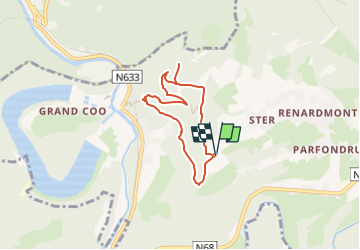
Randonnée Marche de 5,2 km à découvrir à Wallonie, Liège, Stavelot. Cette randonnée est proposée par Au fil de nos découvertes.
Description
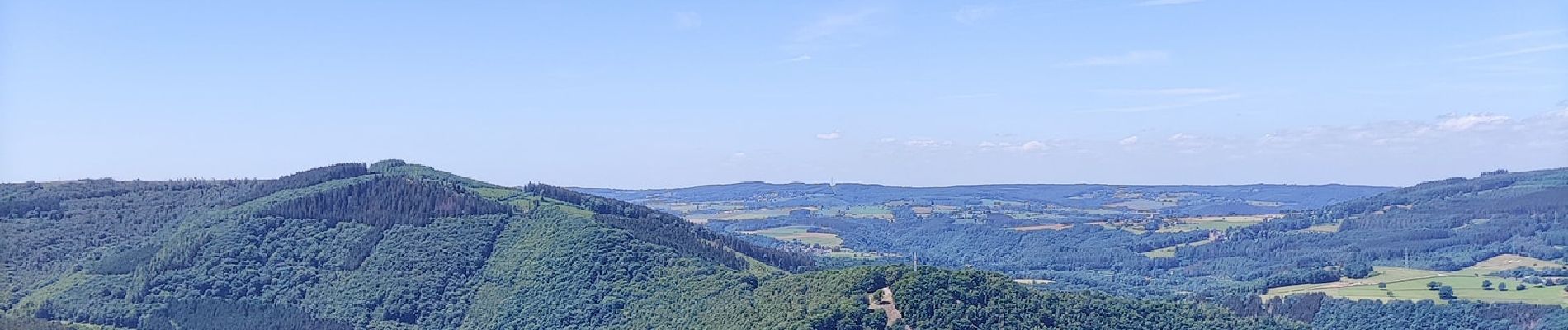
Profitez des magnifiques vues sur le Lac! 😍
🅿️ Départ et Parking:
Chemin des mazures
4970 Stavelot
🥾 Prévoir de bonnes chaussures de marche.
Cela peut être boueux à certains endroits.
▶️ Suivre la balise "rectangle rouge"
Cette promenade vous emmène à travers la forêt vers le point de vue de Ster. ❤️
Nous avons fait un petit détour après le 1er point de vue, vers un deuxième, qui se trouve quelques centaines de mètres plus loin. 👌
(Au lieu de descendre, continuez tout droit).
Lors des beaux jours, vous y verrez certainement des parapentistes et la vue sur les lacs de Coo y est incroyable. 😱
Vous passerez par le Belvédère Thiry et le Belvédère Hardy.
Après, toutes ses jolies vues, une grimpette s'impose pour revenir au point de départ. 😁
Chiens autorisés en laisse. 🐩🐶🐕
Convient pour les enfants . 👱👱♂️
Ne convient pas pour les poussettes et personnes à mobilité réduite. 👨🦽👩🦽👶
N'hésitez pas à aller faire un tour sur notre site internet et nos réseaux :
www.aufildenosdecouvertes.com
www.facebook.com/aufildenosdecouvertes
https://www.instagram.com/au_fil_de_nos_decouvertes
Localisation
Commentaires
Randonnées à proximité
![Randonnée Marche Trois-Ponts - RB-Lg-29_Wanne - Photo](https://media.geolcdn.com/t/375/260/ext.jpg?maxdim=2&url=https%3A%2F%2Fservices.sitytrail.com%2FGeolivesWS%2FDownloadMedia.ashx%3FTrailID%3D402097%26Media%3Dd4589c74-2522-4a62-866b-b5d0038bf075.jpg)
![Marche Marche](https://static1.geolcdn.com/sitytour/trail-icons/101.png)
![Randonnée Marche Trois-Ponts - RB-Lg-27_Trois-Ponts - Photo](https://media.geolcdn.com/t/375/260/ext.jpg?maxdim=2&url=https%3A%2F%2Fservices.sitytrail.com%2FGeolivesWS%2FDownloadMedia.ashx%3FTrailID%3D402090%26Media%3Ddb9e80d9-8efc-4045-abb6-cee4f6885ea2.jpg)
![Marche Marche](https://static1.geolcdn.com/sitytour/trail-icons/101.png)
Marche
![](/images/other/stat-length.png)
![](https://static1.geolcdn.com/siteimages/upload/files/16400158638029165_repeat_loop_refresh_sync_direction_icon.png)
![Randonnée Marche Stavelot - Extratrail_stavelot_13km_new - Photo](https://media.geolcdn.com/t/375/260/acb4a21b-3ac7-4958-9a44-c1358ae78040.jpg&format=jpg&maxdim=2)
![Marche Marche](https://static1.geolcdn.com/sitytour/trail-icons/101.png)
Marche
![](/images/other/stat-length.png)
![](https://static1.geolcdn.com/siteimages/upload/files/16400158638029165_repeat_loop_refresh_sync_direction_icon.png)
![Randonnée Marche Stoumont - La Gleize - P3 - Tour du Mont Saint-Victor - Photo](https://media.geolcdn.com/t/375/260/eeda461f-0b98-4912-915c-63b0e2025382.jpg&format=jpg&maxdim=2)
![Marche Marche](https://static1.geolcdn.com/sitytour/trail-icons/101.png)
Marche
![](/images/other/stat-length.png)
![](https://static1.geolcdn.com/siteimages/upload/files/16400158638029165_repeat_loop_refresh_sync_direction_icon.png)
![Randonnée Marche Stavelot - Stavelot - Photo](https://media.geolcdn.com/t/375/260/8b34c446-55a9-478c-88d7-9cb986b390fb.jpg&format=jpg&maxdim=2)
![Marche Marche](https://static1.geolcdn.com/sitytour/trail-icons/101.png)
Marche
![](/images/other/stat-length.png)
![](https://static1.geolcdn.com/siteimages/upload/files/16400158638029165_repeat_loop_refresh_sync_direction_icon.png)
![Randonnée Marche Trois-Ponts - RB-Lg-27_Trois-Ponts_via-racc - Photo](https://media.geolcdn.com/t/375/260/ext.jpg?maxdim=2&url=https%3A%2F%2Fservices.sitytrail.com%2FGeolivesWS%2FDownloadMedia.ashx%3FTrailID%3D402091%26Media%3Ddb9e80d9-8efc-4045-abb6-cee4f6885ea2.jpg)
![Marche Marche](https://static1.geolcdn.com/sitytour/trail-icons/101.png)
Marche
![](/images/other/stat-length.png)
![](https://static1.geolcdn.com/siteimages/upload/files/16400158638029165_repeat_loop_refresh_sync_direction_icon.png)
![Randonnée Marche Stavelot - Chemin des Sources |étape n°3 STAVELOT – HOCKAI - Photo](https://media.geolcdn.com/t/375/260/77791607-24fa-4b91-a259-1d28dbfa8616.jpg&format=jpg&maxdim=2)
![Marche Marche](https://static1.geolcdn.com/sitytour/trail-icons/101.png)
Marche
![](/images/other/stat-length.png)
![](https://static1.geolcdn.com/siteimages/upload/files/16400158638029165_repeat_loop_refresh_sync_direction_icon.png)
![Randonnée Trail Stavelot - Extra Trail - Stavelot (rouge) 23km - Photo](https://media.geolcdn.com/t/375/260/e53e9997-9f75-44d1-82da-8b0ea05ce39d.jpg&format=jpg&maxdim=2)
![Trail Trail](https://static1.geolcdn.com/sitytour/trail-icons/104.png)
Trail
![](/images/other/stat-length.png)
![](https://static1.geolcdn.com/siteimages/upload/files/16400158638029165_repeat_loop_refresh_sync_direction_icon.png)
![Randonnée Trail Stavelot - Extra Trail - Stavelot (bleu) 13km - Photo](https://media.geolcdn.com/t/375/260/5430f923-8847-4982-8f77-551b984d4068.jpg&format=jpg&maxdim=2)
![Trail Trail](https://static1.geolcdn.com/sitytour/trail-icons/104.png)
Trail
![](/images/other/stat-length.png)
![](https://static1.geolcdn.com/siteimages/upload/files/16400158638029165_repeat_loop_refresh_sync_direction_icon.png)