![](/images/other/stat-length.png)
![Randonnée Marche La Chapelle-Faucher - La Chappelle-Faucher 11km - Photo](https://media.geolcdn.com/t/1900/400/ext.pjpeg?maxdim=2&url=https%3A%2F%2Fstatic1.geolcdn.com%2Fsiteimages%2Fupload%2Ffiles%2F1553511878bg_sport_marche.png)
La Chappelle-Faucher 11km
YV24
Utilisateur
![Longueur](/images/other/stat-length.png)
Longueur
11,3 km
![Altitude max](https://static1.geolcdn.com/siteimages/upload/files/1508320355ic_sort_altitude_max_24dp.png)
Altitude max
206 m
![Dénivelé positif](https://static1.geolcdn.com/siteimages/upload/files/1508320355ic_sort_den_pos_24dp.png)
Dénivelé positif
225 m
![Km-Effort](/images/other/stat-length.png)
Km-Effort
14,3 km
![Altitude min](https://static1.geolcdn.com/siteimages/upload/files/1508320355ic_sort_altitude_min_24dp.png)
Altitude min
119 m
![Dénivelé négatif](https://static1.geolcdn.com/siteimages/upload/files/1508320355ic_sort_den_neg_24dp.png)
Dénivelé négatif
227 m
![Boucle](https://static1.geolcdn.com/siteimages/upload/files/16400158638029165_repeat_loop_refresh_sync_direction_icon.png)
Boucle
Oui
Date de création :
2014-12-10 00:00:00.0
Dernière modification :
2014-12-10 00:00:00.0
![Marche](https://static1.geolcdn.com/sitytour/trail-icons/101.png)
3h06
Difficulté : Facile
![Scannez ce code QR pour ouvrir la randonnée dans l'application SityTrail](https://capi.geolives.com/qq0zvz2zws4bq2lad0pu/sitytour/trails/327930/qr.png?size=200)
Application GPS de randonnée GRATUITE
À propos
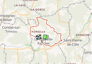
Randonnée Marche de 11,3 km à découvrir à Nouvelle-Aquitaine, Dordogne, La Chapelle-Faucher. Cette randonnée est proposée par YV24.
Description
selon PDIPR carte N°3 Champagnac de Belair. Parcours agréable, bien tracé, varié, peu de bouts de route, bien ombragé et praticable en tout temps. Bons balisage et panneautage.
Localisation
Pays :
France
Région :
Nouvelle-Aquitaine
Département/Province :
Dordogne
Commune :
La Chapelle-Faucher
Localité :
Unknown
Départ:(Dec)
Départ:(UTM)
323859 ; 5026543 (31T) N.
Commentaires
Randonnées à proximité
![Randonnée Marche Saint-Pierre-de-Côle - St pierre de Cole - Brantome - Photo](https://media.geolcdn.com/t/375/260/86969db9-e798-4c6b-a1c6-08184f4a2bc3.jpg&format=jpg&maxdim=2)
![Marche Marche](https://static1.geolcdn.com/sitytour/trail-icons/101.png)
St pierre de Cole - Brantome
Marche
Facile
Saint-Pierre-de-Côle,
Nouvelle-Aquitaine,
Dordogne,
France
![](/images/other/stat-length.png)
17,1 km | 22 km-effort
3h 59min
![](https://static1.geolcdn.com/siteimages/upload/files/16400158638029165_repeat_loop_refresh_sync_direction_icon.png)
Non
![Randonnée Marche Champagnac-de-Belair - Boucle de Champagnac de bel air - Photo](https://media.geolcdn.com/t/375/260/ext.jpg?maxdim=2&url=https%3A%2F%2Fstatic1.geolcdn.com%2Fsiteimages%2Fupload%2Ffiles%2F1553511878bg_sport_marche.png)
![Marche Marche](https://static1.geolcdn.com/sitytour/trail-icons/101.png)
Boucle de Champagnac de bel air
Marche
Difficile
Champagnac-de-Belair,
Nouvelle-Aquitaine,
Dordogne,
France
![](/images/other/stat-length.png)
12,7 km | 15,7 km-effort
3h 33min
![](https://static1.geolcdn.com/siteimages/upload/files/16400158638029165_repeat_loop_refresh_sync_direction_icon.png)
Oui
![Randonnée Marche Saint-Pierre-de-Côle - boucle st pierre de cole - Photo](https://media.geolcdn.com/t/375/260/ext.jpg?maxdim=2&url=https%3A%2F%2Fstatic1.geolcdn.com%2Fsiteimages%2Fupload%2Ffiles%2F1553511878bg_sport_marche.png)
![Marche Marche](https://static1.geolcdn.com/sitytour/trail-icons/101.png)
boucle st pierre de cole
Marche
Moyen
Saint-Pierre-de-Côle,
Nouvelle-Aquitaine,
Dordogne,
France
![](/images/other/stat-length.png)
13,4 km | 16,6 km-effort
3h 27min
![](https://static1.geolcdn.com/siteimages/upload/files/16400158638029165_repeat_loop_refresh_sync_direction_icon.png)
Oui
![Randonnée Marche Saint-Pierre-de-Côle - st pierre brantome - Photo](https://media.geolcdn.com/t/375/260/ext.jpg?maxdim=2&url=https%3A%2F%2Fstatic1.geolcdn.com%2Fsiteimages%2Fupload%2Ffiles%2F1553511878bg_sport_marche.png)
![Marche Marche](https://static1.geolcdn.com/sitytour/trail-icons/101.png)
st pierre brantome
Marche
Difficile
Saint-Pierre-de-Côle,
Nouvelle-Aquitaine,
Dordogne,
France
![](/images/other/stat-length.png)
15,4 km | 19,9 km-effort
2h 45min
![](https://static1.geolcdn.com/siteimages/upload/files/16400158638029165_repeat_loop_refresh_sync_direction_icon.png)
Non
![Randonnée V.T.T. Villars - Mareuil Pauliac Brantôme Pressillac - Photo](https://media.geolcdn.com/t/375/260/ext.jpg?maxdim=2&url=https%3A%2F%2Fstatic1.geolcdn.com%2Fsiteimages%2Fupload%2Ffiles%2F1524743154velo.jpg)
![V.T.T. V.T.T.](https://static1.geolcdn.com/sitytour/trail-icons/202.png)
Mareuil Pauliac Brantôme Pressillac
V.T.T.
Moyen
Villars,
Nouvelle-Aquitaine,
Dordogne,
France
![](/images/other/stat-length.png)
109 km | 136 km-effort
8h 23min
![](https://static1.geolcdn.com/siteimages/upload/files/16400158638029165_repeat_loop_refresh_sync_direction_icon.png)
Oui
![Randonnée Marche Saint-Pierre-de-Côle - St Pierre de Côle Bruzac courte 12km - Photo](https://media.geolcdn.com/t/375/260/ext.jpg?maxdim=2&url=https%3A%2F%2Fstatic1.geolcdn.com%2Fsiteimages%2Fupload%2Ffiles%2F1553511878bg_sport_marche.png)
![Marche Marche](https://static1.geolcdn.com/sitytour/trail-icons/101.png)
St Pierre de Côle Bruzac courte 12km
Marche
Facile
Saint-Pierre-de-Côle,
Nouvelle-Aquitaine,
Dordogne,
France
![](/images/other/stat-length.png)
11,5 km | 14,5 km-effort
3h 10min
![](https://static1.geolcdn.com/siteimages/upload/files/16400158638029165_repeat_loop_refresh_sync_direction_icon.png)
Oui
![Randonnée Marche Saint-Pierre-de-Côle - St Pierre de Côle Bruzac 15km - Photo](https://media.geolcdn.com/t/375/260/ext.jpg?maxdim=2&url=https%3A%2F%2Fstatic1.geolcdn.com%2Fsiteimages%2Fupload%2Ffiles%2F1553511878bg_sport_marche.png)
![Marche Marche](https://static1.geolcdn.com/sitytour/trail-icons/101.png)
St Pierre de Côle Bruzac 15km
Marche
Facile
Saint-Pierre-de-Côle,
Nouvelle-Aquitaine,
Dordogne,
France
![](/images/other/stat-length.png)
15,1 km | 19 km-effort
4h 6min
![](https://static1.geolcdn.com/siteimages/upload/files/16400158638029165_repeat_loop_refresh_sync_direction_icon.png)
Oui
![Randonnée Marche Condat-sur-Trincou - Condat-sur-Trincou Dronne Trincou 13km - Photo](https://media.geolcdn.com/t/375/260/ext.jpg?maxdim=2&url=https%3A%2F%2Fstatic1.geolcdn.com%2Fsiteimages%2Fupload%2Ffiles%2F1553511878bg_sport_marche.png)
![Marche Marche](https://static1.geolcdn.com/sitytour/trail-icons/101.png)
Condat-sur-Trincou Dronne Trincou 13km
Marche
Facile
Condat-sur-Trincou,
Nouvelle-Aquitaine,
Dordogne,
France
![](/images/other/stat-length.png)
12,6 km | 15,8 km-effort
3h 26min
![](https://static1.geolcdn.com/siteimages/upload/files/16400158638029165_repeat_loop_refresh_sync_direction_icon.png)
Oui
![Randonnée Marche Champagnac-de-Belair - Champagnac Belair Drone Trincou - Photo](https://media.geolcdn.com/t/375/260/ext.jpg?maxdim=2&url=https%3A%2F%2Fstatic1.geolcdn.com%2Fsiteimages%2Fupload%2Ffiles%2F1553511878bg_sport_marche.png)
![Marche Marche](https://static1.geolcdn.com/sitytour/trail-icons/101.png)
Champagnac Belair Drone Trincou
Marche
Facile
Champagnac-de-Belair,
Nouvelle-Aquitaine,
Dordogne,
France
![](/images/other/stat-length.png)
13,4 km | 16,7 km-effort
3h 36min
![](https://static1.geolcdn.com/siteimages/upload/files/16400158638029165_repeat_loop_refresh_sync_direction_icon.png)
Oui
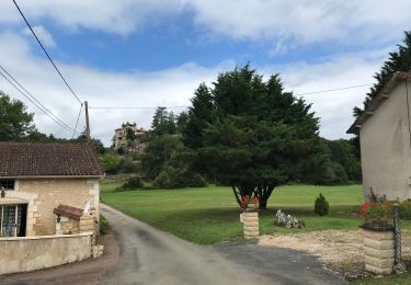
Très très belle randonnée