![](/images/other/stat-length.png)
![Randonnée Marche Hamois - Mohiville ADEPS - Photo](https://media.geolcdn.com/t/1900/400/ext.pjpeg?maxdim=2&url=https%3A%2F%2Fstatic1.geolcdn.com%2Fsiteimages%2Fupload%2Ffiles%2F1553511878bg_sport_marche.png)
Mohiville ADEPS
thomarche
Utilisateur
![Longueur](/images/other/stat-length.png)
Longueur
10 km
![Altitude max](https://static1.geolcdn.com/siteimages/upload/files/1508320355ic_sort_altitude_max_24dp.png)
Altitude max
344 m
![Dénivelé positif](https://static1.geolcdn.com/siteimages/upload/files/1508320355ic_sort_den_pos_24dp.png)
Dénivelé positif
213 m
![Km-Effort](/images/other/stat-length.png)
Km-Effort
12,9 km
![Altitude min](https://static1.geolcdn.com/siteimages/upload/files/1508320355ic_sort_altitude_min_24dp.png)
Altitude min
262 m
![Dénivelé négatif](https://static1.geolcdn.com/siteimages/upload/files/1508320355ic_sort_den_neg_24dp.png)
Dénivelé négatif
235 m
![Boucle](https://static1.geolcdn.com/siteimages/upload/files/16400158638029165_repeat_loop_refresh_sync_direction_icon.png)
Boucle
Non
Date de création :
2022-05-29 09:28:53.0
Dernière modification :
2022-06-10 06:00:41.722
![Marche](https://static1.geolcdn.com/sitytour/trail-icons/101.png)
2h21
Difficulté : Facile
![Scannez ce code QR pour ouvrir la randonnée dans l'application SityTrail](https://capi.geolives.com/qq0zvz2zws4bq2lad0pu/sitytour/trails/3276457/qr.png?size=200)
Application GPS de randonnée GRATUITE
À propos
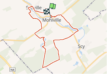
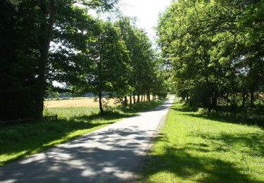
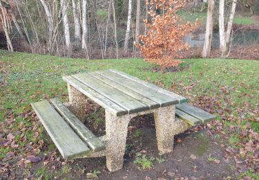
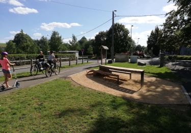
Randonnée Marche de 10 km à découvrir à Wallonie, Namur, Hamois. Cette randonnée est proposée par thomarche.
Description
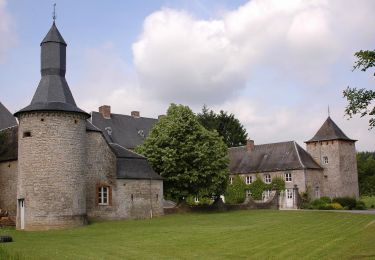
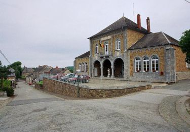
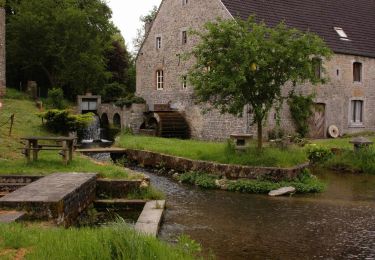
Belle boucle très calme, vues et sentiers. Avec macadam mais très étroits et absolument pas fréquentés. Très beau patrimoine bâti bien entretenu.
Localisation
Pays :
Belgique
Région :
Wallonie
Département/Province :
Namur
Commune :
Hamois
Localité :
Unknown
Départ:(Dec)
Départ:(UTM)
655929 ; 5576548 (31U) N.
Commentaires
Randonnées à proximité
![Randonnée Marche Hamois - HAMOIS- Scy (Mohiville)- Promenade du Berceau du Bocq - Photo](https://media.geolcdn.com/t/375/260/ext.jpg?maxdim=2&url=https%3A%2F%2Fservices.sitytrail.com%2FGeolivesWS%2FDownloadMedia.ashx%3FTrailID%3D250701%26Media%3D514f4968-57f7-4b3e-aef8-c121b3f2a3eb.jpg)
![Marche Marche](https://static1.geolcdn.com/sitytour/trail-icons/101.png)
HAMOIS- Scy (Mohiville)- Promenade du Berceau du Bocq
Marche
Facile
(12)
Hamois,
Wallonie,
Namur,
Belgique
![](/images/other/stat-length.png)
7,9 km | 9,8 km-effort
2h 4min
![](https://static1.geolcdn.com/siteimages/upload/files/16400158638029165_repeat_loop_refresh_sync_direction_icon.png)
Oui
![Randonnée Marche Hamois - HAMOIS- Schaltin- Promenade du Bois du Bocq au Colombier - Photo](https://media.geolcdn.com/t/375/260/ext.jpg?maxdim=2&url=https%3A%2F%2Fservices.sitytrail.com%2FGeolivesWS%2FDownloadMedia.ashx%3FTrailID%3D250699%26Media%3Df5fa6a8e-df6b-4e51-95e3-c58e93d30411.jpg)
![Marche Marche](https://static1.geolcdn.com/sitytour/trail-icons/101.png)
HAMOIS- Schaltin- Promenade du Bois du Bocq au Colombier
Marche
Très facile
(7)
Hamois,
Wallonie,
Namur,
Belgique
![](/images/other/stat-length.png)
4,9 km | 5,8 km-effort
1h 15min
![](https://static1.geolcdn.com/siteimages/upload/files/16400158638029165_repeat_loop_refresh_sync_direction_icon.png)
Oui
![Randonnée Marche Hamois - HAMOIS- Hamois- Promenade du Tige al Creûjette - Photo](https://media.geolcdn.com/t/375/260/ext.jpg?maxdim=2&url=https%3A%2F%2Fservices.sitytrail.com%2FGeolivesWS%2FDownloadMedia.ashx%3FTrailID%3D250668%26Media%3D2dcd42b4-7825-4c6c-b964-62af389c92a8.jpg)
![Marche Marche](https://static1.geolcdn.com/sitytour/trail-icons/101.png)
HAMOIS- Hamois- Promenade du Tige al Creûjette
Marche
Très facile
(3)
Hamois,
Wallonie,
Namur,
Belgique
![](/images/other/stat-length.png)
5,2 km | 6,3 km-effort
1h 22min
![](https://static1.geolcdn.com/siteimages/upload/files/16400158638029165_repeat_loop_refresh_sync_direction_icon.png)
Oui
![Randonnée Marche Hamois - HAMOIS- Achet- Promenade du Chapitre Saint-Paul en Tourlouette - Photo](https://media.geolcdn.com/t/375/260/ext.jpg?maxdim=2&url=https%3A%2F%2Fservices.sitytrail.com%2FGeolivesWS%2FDownloadMedia.ashx%3FTrailID%3D250667%26Media%3D711a5ab0-f1b5-4358-8e7d-16aef65342fb.jpg)
![Marche Marche](https://static1.geolcdn.com/sitytour/trail-icons/101.png)
HAMOIS- Achet- Promenade du Chapitre Saint-Paul en Tourlouette
Marche
Facile
(2)
Hamois,
Wallonie,
Namur,
Belgique
![](/images/other/stat-length.png)
7,3 km | 9 km-effort
1h 52min
![](https://static1.geolcdn.com/siteimages/upload/files/16400158638029165_repeat_loop_refresh_sync_direction_icon.png)
Oui
![Randonnée Marche Havelange - HAVELANGE- Porcheresse- Promenade du Champ du Bois - Photo](https://media.geolcdn.com/t/375/260/ext.jpg?maxdim=2&url=https%3A%2F%2Fservices.sitytrail.com%2FGeolivesWS%2FDownloadMedia.ashx%3FTrailID%3D250669%26Media%3D99c045bc-d8a2-408c-89d7-93e4a625dfbf.jpg)
![Marche Marche](https://static1.geolcdn.com/sitytour/trail-icons/101.png)
HAVELANGE- Porcheresse- Promenade du Champ du Bois
Marche
Facile
(3)
Havelange,
Wallonie,
Namur,
Belgique
![](/images/other/stat-length.png)
14,8 km | 18,5 km-effort
3h 57min
![](https://static1.geolcdn.com/siteimages/upload/files/16400158638029165_repeat_loop_refresh_sync_direction_icon.png)
Oui
![Randonnée Marche Hamois - SENTIERS D'ART - 74 km - Schaltin, Gesves, Ohey, Havelange, Hamois, Schaltin - Photo](https://media.geolcdn.com/t/375/260/ed3535b1-7f98-4002-879c-f79483ce43a3.jpg&format=jpg&maxdim=2)
![Marche Marche](https://static1.geolcdn.com/sitytour/trail-icons/101.png)
SENTIERS D'ART - 74 km - Schaltin, Gesves, Ohey, Havelange, Hamois, Schaltin
Marche
Très difficile
Hamois,
Wallonie,
Namur,
Belgique
![](/images/other/stat-length.png)
74 km | 91 km-effort
20h 36min
![](https://static1.geolcdn.com/siteimages/upload/files/16400158638029165_repeat_loop_refresh_sync_direction_icon.png)
Oui
![Randonnée Marche Hamois - La Promenade du Berceau du Bocq - Photo](https://media.geolcdn.com/t/375/260/c1ecebef-4dce-4991-920f-3cf80ab64a6d.jpg&format=jpg&maxdim=2)
![Marche Marche](https://static1.geolcdn.com/sitytour/trail-icons/101.png)
La Promenade du Berceau du Bocq
Marche
Moyen
(1)
Hamois,
Wallonie,
Namur,
Belgique
![](/images/other/stat-length.png)
9,3 km | 11,2 km-effort
4h 41min
![](https://static1.geolcdn.com/siteimages/upload/files/16400158638029165_repeat_loop_refresh_sync_direction_icon.png)
Oui
![Randonnée A pied Havelange - Porcheresse: Promenade du Bois de Porcheresse - Photo](https://media.geolcdn.com/t/375/260/ext.jpg?maxdim=2&url=https%3A%2F%2Fpivotmedia.tourismewallonie.be%2FOTH-A0-0035-12HV%2FOTH-A0-0035-12HV.jpg)
![A pied A pied](https://static1.geolcdn.com/sitytour/trail-icons/100.png)
Porcheresse: Promenade du Bois de Porcheresse
A pied
Facile
(2)
Havelange,
Wallonie,
Namur,
Belgique
![](/images/other/stat-length.png)
7,2 km | 8,8 km-effort
2h 0min
![](https://static1.geolcdn.com/siteimages/upload/files/16400158638029165_repeat_loop_refresh_sync_direction_icon.png)
Oui
![Randonnée A pied Hamois - HAMOIS: Du Val du Mauge au Tige de Buresse - Photo](https://media.geolcdn.com/t/375/260/ext.jpg?maxdim=2&url=https%3A%2F%2Fpivotmedia.tourismewallonie.be%2FOTH-A0-004I-17XW%2FOTH-A0-004I-17XW.jpg)
![A pied A pied](https://static1.geolcdn.com/sitytour/trail-icons/100.png)
HAMOIS: Du Val du Mauge au Tige de Buresse
A pied
Facile
(1)
Hamois,
Wallonie,
Namur,
Belgique
![](/images/other/stat-length.png)
8,6 km | 10,6 km-effort
2h 23min
![](https://static1.geolcdn.com/siteimages/upload/files/16400158638029165_repeat_loop_refresh_sync_direction_icon.png)
Oui