![](/images/other/stat-length.png)
![Randonnée Marche Vleteren - West-Vleteren - Photo](https://media.geolcdn.com/t/1900/400/f1689873-0846-4b61-b2a2-e0d6e0117584.jpg&format=pjpeg&maxdim=2)
West-Vleteren
Geert H.
Utilisateur
![Longueur](/images/other/stat-length.png)
Longueur
18,2 km
![Altitude max](https://static1.geolcdn.com/siteimages/upload/files/1508320355ic_sort_altitude_max_24dp.png)
Altitude max
28 m
![Dénivelé positif](https://static1.geolcdn.com/siteimages/upload/files/1508320355ic_sort_den_pos_24dp.png)
Dénivelé positif
79 m
![Km-Effort](/images/other/stat-length.png)
Km-Effort
19,3 km
![Altitude min](https://static1.geolcdn.com/siteimages/upload/files/1508320355ic_sort_altitude_min_24dp.png)
Altitude min
6 m
![Dénivelé négatif](https://static1.geolcdn.com/siteimages/upload/files/1508320355ic_sort_den_neg_24dp.png)
Dénivelé négatif
79 m
![Boucle](https://static1.geolcdn.com/siteimages/upload/files/16400158638029165_repeat_loop_refresh_sync_direction_icon.png)
Boucle
Oui
Date de création :
2022-06-04 08:19:19.159
Dernière modification :
2022-06-05 08:55:37.059
![Marche](https://static1.geolcdn.com/sitytour/trail-icons/101.png)
3h43
Difficulté : Facile
![Scannez ce code QR pour ouvrir la randonnée dans l'application SityTrail](https://capi.geolives.com/qq0zvz2zws4bq2lad0pu/sitytour/trails/3269380/qr.png?size=200)
Application GPS de randonnée GRATUITE
À propos
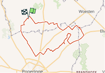
Randonnée Marche de 18,2 km à découvrir à Flandre, Flandre-Occidentale, Vleteren. Cette randonnée est proposée par Geert H..
Description
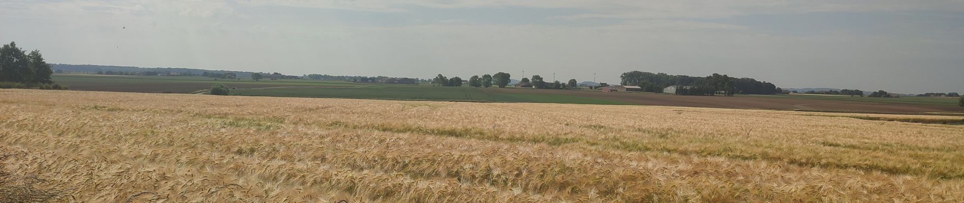
Van de abdij van West-Vleteren richting het Galgenbos. Wegens tijdsgebrek echter het bos laten vallen en langs de Poperingevaart terug gekeerd. Onderweg kom je voorbij aan 2 militaire begraafplaatsen uit WOI nl. Canada Farm Cemetery en Gwalia Cemetery.
Localisation
Pays :
Belgique
Région :
Flandre
Département/Province :
Flandre-Occidentale
Commune :
Vleteren
Localité :
Westvleteren
Départ:(Dec)
Départ:(UTM)
480457 ; 5638297 (31U) N.
Commentaires
Randonnées à proximité
![Randonnée A pied Ypres - Galgebossen - Photo](https://media.geolcdn.com/t/375/260/507b6ec6-4b8d-4ba5-a0c4-d06ce4eec140.jpeg&format=jpg&maxdim=2)
![A pied A pied](https://static1.geolcdn.com/sitytour/trail-icons/100.png)
Galgebossen
A pied
Facile
Ypres,
Flandre,
Flandre-Occidentale,
Belgique
![](/images/other/stat-length.png)
6,2 km | 7,1 km-effort
1h 37min
![](https://static1.geolcdn.com/siteimages/upload/files/16400158638029165_repeat_loop_refresh_sync_direction_icon.png)
Oui
![Randonnée A pied Vleteren - Sint-Sixtus wandelroute - Photo](https://media.geolcdn.com/t/375/260/d7a18a7d-eaf1-483e-80b1-b669c1fe0f42.jpeg&format=jpg&maxdim=2)
![A pied A pied](https://static1.geolcdn.com/sitytour/trail-icons/100.png)
Sint-Sixtus wandelroute
A pied
Facile
Vleteren,
Flandre,
Flandre-Occidentale,
Belgique
![](/images/other/stat-length.png)
7 km | 7,8 km-effort
1h 46min
![](https://static1.geolcdn.com/siteimages/upload/files/16400158638029165_repeat_loop_refresh_sync_direction_icon.png)
Oui
![Randonnée Marche Alveringem - Door Vlaamse velden en IJzervallei - Photo](https://media.geolcdn.com/t/375/260/63593ed0-27b0-4160-8944-784a7421a9e4.jpg&format=jpg&maxdim=2)
![Marche Marche](https://static1.geolcdn.com/sitytour/trail-icons/101.png)
Door Vlaamse velden en IJzervallei
Marche
Moyen
Alveringem,
Flandre,
Flandre-Occidentale,
Belgique
![](/images/other/stat-length.png)
9,9 km | 10,2 km-effort
2h 48min
![](https://static1.geolcdn.com/siteimages/upload/files/16400158638029165_repeat_loop_refresh_sync_direction_icon.png)
Oui
![Randonnée Cheval Vleteren - west vleteren - Photo](https://media.geolcdn.com/t/375/260/ext.jpg?maxdim=2&url=https%3A%2F%2Fstatic1.geolcdn.com%2Fsiteimages%2Fupload%2Ffiles%2F1524743154cheval.jpg)
![Cheval Cheval](https://static1.geolcdn.com/sitytour/trail-icons/300.png)
west vleteren
Cheval
Très facile
Vleteren,
Flandre,
Flandre-Occidentale,
Belgique
![](/images/other/stat-length.png)
24 km | 26 km-effort
3h 6min
![](https://static1.geolcdn.com/siteimages/upload/files/16400158638029165_repeat_loop_refresh_sync_direction_icon.png)
Oui
![Randonnée Marche Poperinge - Poperinge-Watou (PVDB) - Photo](https://media.geolcdn.com/t/375/260/ext.jpg?maxdim=2&url=https%3A%2F%2Fstatic1.geolcdn.com%2Fsiteimages%2Fupload%2Ffiles%2F1553511878bg_sport_marche.png)
![Marche Marche](https://static1.geolcdn.com/sitytour/trail-icons/101.png)
Poperinge-Watou (PVDB)
Marche
Très facile
Poperinge,
Flandre,
Flandre-Occidentale,
Belgique
![](/images/other/stat-length.png)
23 km | 25 km-effort
Inconnu
![](https://static1.geolcdn.com/siteimages/upload/files/16400158638029165_repeat_loop_refresh_sync_direction_icon.png)
Non
![Randonnée Marche Vleteren - Sint-Sixtuswandelroute - Photo](https://media.geolcdn.com/t/375/260/ext.jpg?maxdim=2&url=https%3A%2F%2Fstatic1.geolcdn.com%2Fsiteimages%2Fupload%2Ffiles%2F1553511878bg_sport_marche.png)
![Marche Marche](https://static1.geolcdn.com/sitytour/trail-icons/101.png)
Sint-Sixtuswandelroute
Marche
Très facile
(1)
Vleteren,
Flandre,
Flandre-Occidentale,
Belgique
![](/images/other/stat-length.png)
7,1 km | 7,9 km-effort
Inconnu
![](https://static1.geolcdn.com/siteimages/upload/files/16400158638029165_repeat_loop_refresh_sync_direction_icon.png)
Oui
![Randonnée Marche Vleteren - Brabanthoekwandelroute - Photo](https://media.geolcdn.com/t/375/260/ext.jpg?maxdim=2&url=https%3A%2F%2Fstatic1.geolcdn.com%2Fsiteimages%2Fupload%2Ffiles%2F1553511878bg_sport_marche.png)
![Marche Marche](https://static1.geolcdn.com/sitytour/trail-icons/101.png)
Brabanthoekwandelroute
Marche
Très facile
Vleteren,
Flandre,
Flandre-Occidentale,
Belgique
![](/images/other/stat-length.png)
6,7 km | 6,9 km-effort
Inconnu
![](https://static1.geolcdn.com/siteimages/upload/files/16400158638029165_repeat_loop_refresh_sync_direction_icon.png)
Oui
![Randonnée Marche Vleteren - Westvleteren - Trappist 3 - Photo](https://media.geolcdn.com/t/375/260/ext.jpg?maxdim=2&url=https%3A%2F%2Fstatic1.geolcdn.com%2Fsiteimages%2Fupload%2Ffiles%2F1553511878bg_sport_marche.png)
![Marche Marche](https://static1.geolcdn.com/sitytour/trail-icons/101.png)
Westvleteren - Trappist 3
Marche
Facile
Vleteren,
Flandre,
Flandre-Occidentale,
Belgique
![](/images/other/stat-length.png)
26 km | 28 km-effort
4h 30min
![](https://static1.geolcdn.com/siteimages/upload/files/16400158638029165_repeat_loop_refresh_sync_direction_icon.png)
Oui
![Randonnée Vélo électrique Vleteren - Bierfietsroute Vleteren - Alveringem - Lo-Reninge - 98 (1) - Photo](https://media.geolcdn.com/t/375/260/ext.jpg?maxdim=2&url=https%3A%2F%2Fstatic1.geolcdn.com%2Fsiteimages%2Fupload%2Ffiles%2F1524743154velo.jpg)
![Vélo électrique Vélo électrique](https://static1.geolcdn.com/sitytour/trail-icons/205.png)
Bierfietsroute Vleteren - Alveringem - Lo-Reninge - 98 (1)
Vélo électrique
Très facile
Vleteren,
Flandre,
Flandre-Occidentale,
Belgique
![](/images/other/stat-length.png)
34 km | 36 km-effort
Inconnu
![](https://static1.geolcdn.com/siteimages/upload/files/16400158638029165_repeat_loop_refresh_sync_direction_icon.png)
Oui