![](/images/other/stat-length.png)
![Randonnée Marche Figeac - Etape13 Figeac a Carjac - Photo](https://media.geolcdn.com/t/1900/400/efd60137-13f6-40d5-b090-132567a61345.jpg&format=pjpeg&maxdim=2)
Etape13 Figeac a Carjac
lesduj
Utilisateur
![Longueur](/images/other/stat-length.png)
Longueur
32 km
![Altitude max](https://static1.geolcdn.com/siteimages/upload/files/1508320355ic_sort_altitude_max_24dp.png)
Altitude max
400 m
![Dénivelé positif](https://static1.geolcdn.com/siteimages/upload/files/1508320355ic_sort_den_pos_24dp.png)
Dénivelé positif
693 m
![Km-Effort](/images/other/stat-length.png)
Km-Effort
42 km
![Altitude min](https://static1.geolcdn.com/siteimages/upload/files/1508320355ic_sort_altitude_min_24dp.png)
Altitude min
153 m
![Dénivelé négatif](https://static1.geolcdn.com/siteimages/upload/files/1508320355ic_sort_den_neg_24dp.png)
Dénivelé négatif
737 m
![Boucle](https://static1.geolcdn.com/siteimages/upload/files/16400158638029165_repeat_loop_refresh_sync_direction_icon.png)
Boucle
Non
Date de création :
2022-06-02 13:39:06.0
Dernière modification :
2022-06-04 04:34:11.442
![Marche](https://static1.geolcdn.com/sitytour/trail-icons/101.png)
7h40
Difficulté : Difficile
![Scannez ce code QR pour ouvrir la randonnée dans l'application SityTrail](https://capi.geolives.com/qq0zvz2zws4bq2lad0pu/sitytour/trails/3268941/qr.png?size=200)
Application GPS de randonnée GRATUITE
À propos
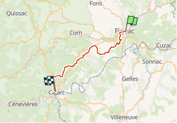
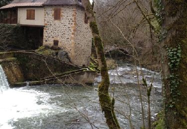
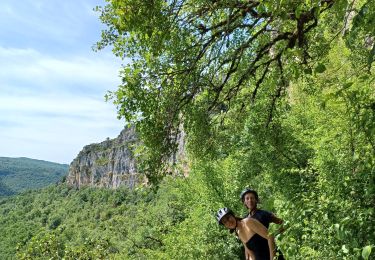
Randonnée Marche de 32 km à découvrir à Occitanie, Lot, Figeac. Cette randonnée est proposée par lesduj.
Description
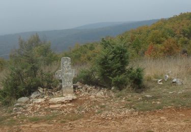
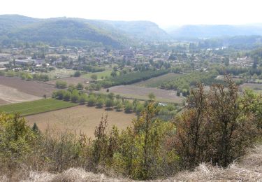
Randonnée de 31 kms sur le GR65 difficile dû à ses grandes distances sur le bitume et ses belles montées.
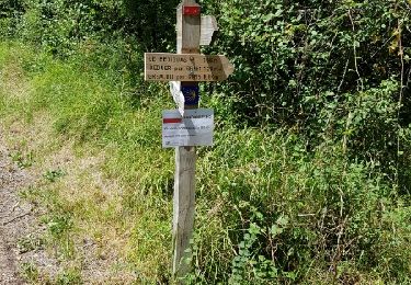
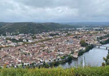
L’arrivée sur Carjac vous offre une vue magnifique.
N’oubliez pas de visiter la grotte à droite sur le chemin en arrivant sur Carjac.Bonne Randonnée a tous
Localisation
Pays :
France
Région :
Occitanie
Département/Province :
Lot
Commune :
Figeac
Localité :
Unknown
Départ:(Dec)
Départ:(UTM)
423395 ; 4939705 (31T) N.
Commentaires
Randonnées à proximité
![Randonnée Marche Figeac - Compostelle 2: 1-Figeac - Espagnac - Photo](https://media.geolcdn.com/t/375/260/ext.jpg?maxdim=2&url=https%3A%2F%2Fservices.sitytrail.com%2FGeolivesWS%2FDownloadMedia.ashx%3FTrailID%3D606459%26Media%3Dfix__20160723135745.jpg)
![Marche Marche](https://static1.geolcdn.com/sitytour/trail-icons/101.png)
Compostelle 2: 1-Figeac - Espagnac
Marche
Moyen
(1)
Figeac,
Occitanie,
Lot,
France
![](/images/other/stat-length.png)
27 km | 34 km-effort
6h 35min
![](https://static1.geolcdn.com/siteimages/upload/files/16400158638029165_repeat_loop_refresh_sync_direction_icon.png)
Non
![Randonnée Marche Faycelles - La vallée du Célé - Photo](https://media.geolcdn.com/t/375/260/4eba304e-1100-4f16-9269-d2537ca072bf.jpg&format=jpg&maxdim=2)
![Marche Marche](https://static1.geolcdn.com/sitytour/trail-icons/101.png)
La vallée du Célé
Marche
Très difficile
Faycelles,
Occitanie,
Lot,
France
![](/images/other/stat-length.png)
111 km | 153 km-effort
35h 59min
![](https://static1.geolcdn.com/siteimages/upload/files/16400158638029165_repeat_loop_refresh_sync_direction_icon.png)
Non
![Randonnée Marche Faycelles - Étape 1 Faycelle St Sulpice - Photo](https://media.geolcdn.com/t/375/260/23b33cbc-f63d-4c4e-948e-69bfb3efba87.jpg&format=jpg&maxdim=2)
![Marche Marche](https://static1.geolcdn.com/sitytour/trail-icons/101.png)
Étape 1 Faycelle St Sulpice
Marche
Difficile
Faycelles,
Occitanie,
Lot,
France
![](/images/other/stat-length.png)
28 km | 37 km-effort
7h 46min
![](https://static1.geolcdn.com/siteimages/upload/files/16400158638029165_repeat_loop_refresh_sync_direction_icon.png)
Non
![Marche Marche](https://static1.geolcdn.com/sitytour/trail-icons/101.png)
CC_Velay_CC_12_Figeac_Cajarc_20071103
Marche
Moyen
(1)
Figeac,
Occitanie,
Lot,
France
![](/images/other/stat-length.png)
30 km | 39 km-effort
7h 0min
![](https://static1.geolcdn.com/siteimages/upload/files/16400158638029165_repeat_loop_refresh_sync_direction_icon.png)
Non
![Randonnée Marche Faycelles - Mon Compostelle sixième étape - Photo](https://media.geolcdn.com/t/375/260/ext.jpg?maxdim=2&url=https%3A%2F%2Fservices.sitytrail.com%2FGeolivesWS%2FDownloadMedia.ashx%3FTrailID%3D682900%26Media%3D54ab3826-f9fa-4a63-b904-0665847fae64.JPG)
![Marche Marche](https://static1.geolcdn.com/sitytour/trail-icons/101.png)
Mon Compostelle sixième étape
Marche
Difficile
Faycelles,
Occitanie,
Lot,
France
![](/images/other/stat-length.png)
43 km | 55 km-effort
9h 40min
![](https://static1.geolcdn.com/siteimages/upload/files/16400158638029165_repeat_loop_refresh_sync_direction_icon.png)
Non
![Randonnée Cheval Lissac-et-Mouret - La Cazelle-Camburat-Mouret-La Cazelle - Photo](https://media.geolcdn.com/t/375/260/ext.jpg?maxdim=2&url=https%3A%2F%2Fstatic1.geolcdn.com%2Fsiteimages%2Fupload%2Ffiles%2F1524743154cheval.jpg)
![Cheval Cheval](https://static1.geolcdn.com/sitytour/trail-icons/300.png)
La Cazelle-Camburat-Mouret-La Cazelle
Cheval
Facile
(1)
Lissac-et-Mouret,
Occitanie,
Lot,
France
![](/images/other/stat-length.png)
13,9 km | 17,5 km-effort
2h 43min
![](https://static1.geolcdn.com/siteimages/upload/files/16400158638029165_repeat_loop_refresh_sync_direction_icon.png)
Oui
![Randonnée V.T.T. Capdenac-Gare - capdenac - Photo](https://media.geolcdn.com/t/375/260/ext.jpg?maxdim=2&url=https%3A%2F%2Fservices.sitytrail.com%2FGeolivesWS%2FDownloadMedia.ashx%3FTrailID%3D183699%26Media%3D20130323121202.jpg)
![V.T.T. V.T.T.](https://static1.geolcdn.com/sitytour/trail-icons/202.png)
capdenac
V.T.T.
Moyen
(1)
Capdenac-Gare,
Occitanie,
Aveyron,
France
![](/images/other/stat-length.png)
34 km | 45 km-effort
4h 13min
![](https://static1.geolcdn.com/siteimages/upload/files/16400158638029165_repeat_loop_refresh_sync_direction_icon.png)
Oui
![Randonnée sport Figeac - 20240418 Figeac (hôtel les Bains)-Rian (les ânes du Célé) - Photo](https://media.geolcdn.com/t/375/260/1e2c3c3a-2cb9-4aa8-8a80-efa83001be61.jpg&format=jpg&maxdim=2)
20240418 Figeac (hôtel les Bains)-Rian (les ânes du Célé)
sport
Très facile
Figeac,
Occitanie,
Lot,
France
![](/images/other/stat-length.png)
24 km | 31 km-effort
Inconnu
![](https://static1.geolcdn.com/siteimages/upload/files/16400158638029165_repeat_loop_refresh_sync_direction_icon.png)
Non
![Randonnée V.T.T. Faycelles - figeac cassagnole st cirq la popie - Photo](https://media.geolcdn.com/t/375/260/dec37c16-3b87-4c7b-bf34-266ba0f94195.jpg&format=jpg&maxdim=2)
![V.T.T. V.T.T.](https://static1.geolcdn.com/sitytour/trail-icons/202.png)
figeac cassagnole st cirq la popie
V.T.T.
Moyen
Faycelles,
Occitanie,
Lot,
France
![](/images/other/stat-length.png)
68 km | 89 km-effort
9h 21min
![](https://static1.geolcdn.com/siteimages/upload/files/16400158638029165_repeat_loop_refresh_sync_direction_icon.png)
Non