![](/images/other/stat-length.png)
![Randonnée Marche La Motte - z les demoiselles 31-05-22 - Photo](https://media.geolcdn.com/t/1900/400/b7a4b6dc-88ae-49a1-b80b-8e3c1e6c855a.jpg&format=pjpeg&maxdim=2)
z les demoiselles 31-05-22
cb8310
Utilisateur
![Longueur](/images/other/stat-length.png)
Longueur
6,4 km
![Altitude max](https://static1.geolcdn.com/siteimages/upload/files/1508320355ic_sort_altitude_max_24dp.png)
Altitude max
104 m
![Dénivelé positif](https://static1.geolcdn.com/siteimages/upload/files/1508320355ic_sort_den_pos_24dp.png)
Dénivelé positif
79 m
![Km-Effort](/images/other/stat-length.png)
Km-Effort
7,4 km
![Altitude min](https://static1.geolcdn.com/siteimages/upload/files/1508320355ic_sort_altitude_min_24dp.png)
Altitude min
35 m
![Dénivelé négatif](https://static1.geolcdn.com/siteimages/upload/files/1508320355ic_sort_den_neg_24dp.png)
Dénivelé négatif
82 m
![Boucle](https://static1.geolcdn.com/siteimages/upload/files/16400158638029165_repeat_loop_refresh_sync_direction_icon.png)
Boucle
Oui
Date de création :
2022-05-31 07:06:04.708
Dernière modification :
2022-06-01 06:18:19.099
![Marche](https://static1.geolcdn.com/sitytour/trail-icons/101.png)
2h36
Difficulté : Moyen
![Scannez ce code QR pour ouvrir la randonnée dans l'application SityTrail](https://capi.geolives.com/qq0zvz2zws4bq2lad0pu/sitytour/trails/3264313/qr.png?size=200)
Application GPS de randonnée GRATUITE
À propos
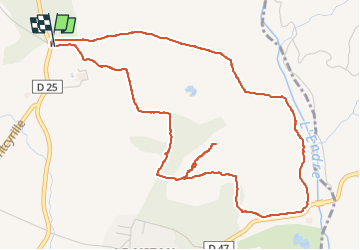
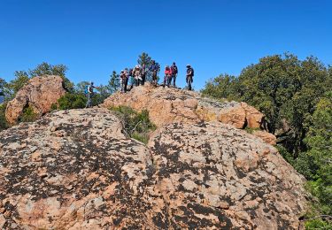
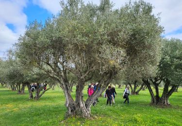
Randonnée Marche de 6,4 km à découvrir à Provence-Alpes-Côte d'Azur, Var, La Motte. Cette randonnée est proposée par cb8310.
Description
rando avec quelques montées courtes mais un peu difficiles un sentier qui n'existe que sur la carte IGN et non en réalité, ce qui nous a obligé à rebrousser chemin
Localisation
Pays :
France
Région :
Provence-Alpes-Côte d'Azur
Département/Province :
Var
Commune :
La Motte
Localité :
Unknown
Départ:(Dec)
Départ:(UTM)
303318 ; 4820679 (32T) N.
Commentaires
Randonnées à proximité
![Randonnée Marche Le Muy - les grottes Baume Renaude - Photo](https://media.geolcdn.com/t/375/260/83f6db30-c43d-4bf1-a9a3-011d52f73567.jpg&format=jpg&maxdim=2)
![Marche Marche](https://static1.geolcdn.com/sitytour/trail-icons/101.png)
les grottes Baume Renaude
Marche
Difficile
(1)
Le Muy,
Provence-Alpes-Côte d'Azur,
Var,
France
![](/images/other/stat-length.png)
13,3 km | 18,3 km-effort
5h 13min
![](https://static1.geolcdn.com/siteimages/upload/files/16400158638029165_repeat_loop_refresh_sync_direction_icon.png)
Non
![Randonnée Marche Callas - gorge de Penafore - Photo](https://media.geolcdn.com/t/375/260/19f2f069-7b40-4577-819a-e6663f6d8c61.jpg&format=jpg&maxdim=2)
![Marche Marche](https://static1.geolcdn.com/sitytour/trail-icons/101.png)
gorge de Penafore
Marche
Très facile
(1)
Callas,
Provence-Alpes-Côte d'Azur,
Var,
France
![](/images/other/stat-length.png)
1,1 km | 1,3 km-effort
1h 33min
![](https://static1.geolcdn.com/siteimages/upload/files/16400158638029165_repeat_loop_refresh_sync_direction_icon.png)
Oui
![Randonnée Marche Le Muy - Le Castel Diaou - Crête Fille d'Isnard depuis le pont de L'Endre - Photo](https://media.geolcdn.com/t/375/260/be9a20a4-3a2b-4a58-ad48-d15f8920c7dd.jpg&format=jpg&maxdim=2)
![Marche Marche](https://static1.geolcdn.com/sitytour/trail-icons/101.png)
Le Castel Diaou - Crête Fille d'Isnard depuis le pont de L'Endre
Marche
Très difficile
Le Muy,
Provence-Alpes-Côte d'Azur,
Var,
France
![](/images/other/stat-length.png)
22 km | 31 km-effort
7h 4min
![](https://static1.geolcdn.com/siteimages/upload/files/16400158638029165_repeat_loop_refresh_sync_direction_icon.png)
Oui
![Randonnée Marche Le Muy - Pas des Vaches - Pic rébéquier - Fontaine du Chasseur - Pic Castel Diaou - Photo](https://media.geolcdn.com/t/375/260/2b85ee09-1824-4ac8-a041-9e96b6f63a59.jpg&format=jpg&maxdim=2)
![Marche Marche](https://static1.geolcdn.com/sitytour/trail-icons/101.png)
Pas des Vaches - Pic rébéquier - Fontaine du Chasseur - Pic Castel Diaou
Marche
Très difficile
Le Muy,
Provence-Alpes-Côte d'Azur,
Var,
France
![](/images/other/stat-length.png)
22 km | 30 km-effort
6h 55min
![](https://static1.geolcdn.com/siteimages/upload/files/16400158638029165_repeat_loop_refresh_sync_direction_icon.png)
Oui
![Randonnée Marche Roquebrune-sur-Argens - les merles 2 - Photo](https://media.geolcdn.com/t/375/260/ext.jpg?maxdim=2&url=https%3A%2F%2Fstatic1.geolcdn.com%2Fsiteimages%2Fupload%2Ffiles%2F1553511878bg_sport_marche.png)
![Marche Marche](https://static1.geolcdn.com/sitytour/trail-icons/101.png)
les merles 2
Marche
Moyen
(1)
Roquebrune-sur-Argens,
Provence-Alpes-Côte d'Azur,
Var,
France
![](/images/other/stat-length.png)
6,6 km | 7,9 km-effort
1h 47min
![](https://static1.geolcdn.com/siteimages/upload/files/16400158638029165_repeat_loop_refresh_sync_direction_icon.png)
Oui
![Randonnée Marche Le Muy - z l'Endre 05-11-24 - Photo](https://media.geolcdn.com/t/375/260/65ef0e16-5892-4283-8ef2-d7b65c70199a.jpg&format=jpg&maxdim=2)
![Marche Marche](https://static1.geolcdn.com/sitytour/trail-icons/101.png)
z l'Endre 05-11-24
Marche
Moyen
Le Muy,
Provence-Alpes-Côte d'Azur,
Var,
France
![](/images/other/stat-length.png)
6,7 km | 8,1 km-effort
2h 17min
![](https://static1.geolcdn.com/siteimages/upload/files/16400158638029165_repeat_loop_refresh_sync_direction_icon.png)
Oui
![Randonnée A pied La Motte - Massif de la Colle du Rouet 25-09-2024 - Photo](https://media.geolcdn.com/t/375/260/4107a712-55c1-481b-90f6-bb916ccc3554.jpg&format=jpg&maxdim=2)
![A pied A pied](https://static1.geolcdn.com/sitytour/trail-icons/100.png)
Massif de la Colle du Rouet 25-09-2024
A pied
Moyen
La Motte,
Provence-Alpes-Côte d'Azur,
Var,
France
![](/images/other/stat-length.png)
17,4 km | 25 km-effort
5h 38min
![](https://static1.geolcdn.com/siteimages/upload/files/16400158638029165_repeat_loop_refresh_sync_direction_icon.png)
Oui
![Randonnée Marche Le Muy - Roches de la fille Isnard, du Pont d'Endre Le Muy - Photo](https://media.geolcdn.com/t/375/260/5a621cd3-9532-4383-9ace-ccf70fe1b0c2.jpg&format=jpg&maxdim=2)
![Marche Marche](https://static1.geolcdn.com/sitytour/trail-icons/101.png)
Roches de la fille Isnard, du Pont d'Endre Le Muy
Marche
Moyen
Le Muy,
Provence-Alpes-Côte d'Azur,
Var,
France
![](/images/other/stat-length.png)
16,6 km | 23 km-effort
5h 16min
![](https://static1.geolcdn.com/siteimages/upload/files/16400158638029165_repeat_loop_refresh_sync_direction_icon.png)
Oui
![Randonnée Marche Les Arcs-sur-Argens - LES ARCS - LE MUY - LA MOTTE - SAINTE ROSELINE ET VALBOURGES - Photo](https://media.geolcdn.com/t/375/260/24a596bd-8063-44a1-bfa4-688d03d8c334.jpg&format=jpg&maxdim=2)
![Marche Marche](https://static1.geolcdn.com/sitytour/trail-icons/101.png)
LES ARCS - LE MUY - LA MOTTE - SAINTE ROSELINE ET VALBOURGES
Marche
Facile
Les Arcs-sur-Argens,
Provence-Alpes-Côte d'Azur,
Var,
France
![](/images/other/stat-length.png)
9,1 km | 10,4 km-effort
6h 42min
![](https://static1.geolcdn.com/siteimages/upload/files/16400158638029165_repeat_loop_refresh_sync_direction_icon.png)
Oui