![](/images/other/stat-length.png)
![Randonnée Marche Coulommiers-la-Tour - Les Bois d'Huchigny, des Péseries et de Villemalin - Photo](https://media.geolcdn.com/t/1900/400/1e5a6493-d7e8-4e9e-ba35-4686ce9056bf.jpg&format=pjpeg&maxdim=2)
Les Bois d'Huchigny, des Péseries et de Villemalin
guydu41
Utilisateur
![Longueur](/images/other/stat-length.png)
Longueur
8,7 km
![Altitude max](https://static1.geolcdn.com/siteimages/upload/files/1508320355ic_sort_altitude_max_24dp.png)
Altitude max
135 m
![Dénivelé positif](https://static1.geolcdn.com/siteimages/upload/files/1508320355ic_sort_den_pos_24dp.png)
Dénivelé positif
126 m
![Km-Effort](/images/other/stat-length.png)
Km-Effort
10,4 km
![Altitude min](https://static1.geolcdn.com/siteimages/upload/files/1508320355ic_sort_altitude_min_24dp.png)
Altitude min
87 m
![Dénivelé négatif](https://static1.geolcdn.com/siteimages/upload/files/1508320355ic_sort_den_neg_24dp.png)
Dénivelé négatif
127 m
![Boucle](https://static1.geolcdn.com/siteimages/upload/files/16400158638029165_repeat_loop_refresh_sync_direction_icon.png)
Boucle
Oui
Date de création :
2022-05-30 12:04:23.062
Dernière modification :
2022-05-30 15:30:40.454
![Marche](https://static1.geolcdn.com/sitytour/trail-icons/101.png)
2h14
Difficulté : Moyen
![Scannez ce code QR pour ouvrir la randonnée dans l'application SityTrail](https://capi.geolives.com/qq0zvz2zws4bq2lad0pu/sitytour/trails/3263420/qr.png?size=200)
Application GPS de randonnée GRATUITE
À propos
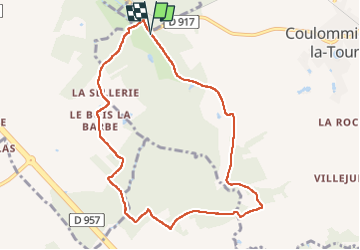
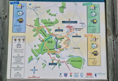
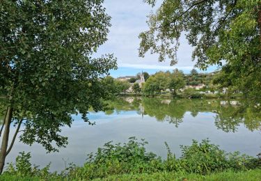
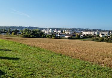
Randonnée Marche de 8,7 km à découvrir à Centre-Val de Loire, Loir-et-Cher, Coulommiers-la-Tour. Cette randonnée est proposée par guydu41.
Description
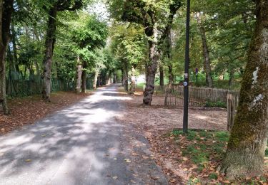
Cette randonnée en boucle démarre depuis le chemin à côté du château d'Huchigny et à proximité de la D917.
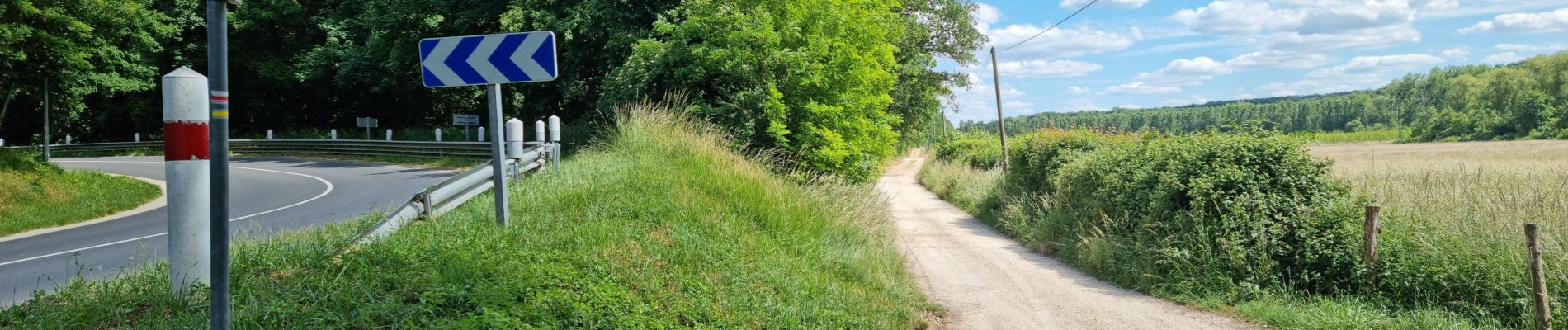
Il emprunte une partie du GR353, traverse plusieurs bois et franchit le Ruisseau du Pont aux Chevaux sur une toute petite passerelle.
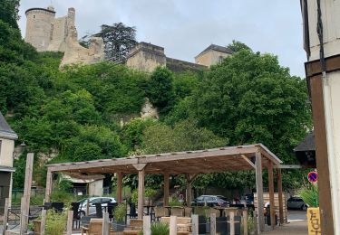
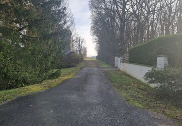
Localisation
Pays :
France
Région :
Centre-Val de Loire
Département/Province :
Loir-et-Cher
Commune :
Coulommiers-la-Tour
Localité :
Unknown
Départ:(Dec)
Départ:(UTM)
358470 ; 5294041 (31T) N.
Commentaires
Randonnées à proximité
![Randonnée Marche Vendôme - Voie de Tours - Poiriers - Vendôme - Prunay Cassereau - Photo](https://media.geolcdn.com/t/375/260/e1f85ff8-5dc9-4860-aac3-2c0f20ccd4d1.jpg&format=jpg&maxdim=2)
![Marche Marche](https://static1.geolcdn.com/sitytour/trail-icons/101.png)
Voie de Tours - Poiriers - Vendôme - Prunay Cassereau
Marche
Facile
Vendôme,
Centre-Val de Loire,
Loir-et-Cher,
France
![](/images/other/stat-length.png)
25 km | 28 km-effort
4h 30min
![](https://static1.geolcdn.com/siteimages/upload/files/16400158638029165_repeat_loop_refresh_sync_direction_icon.png)
Non
![Randonnée Marche Sainte-Anne - Sainte-Anne - Photo](https://media.geolcdn.com/t/375/260/24b1063f-e6f0-46cc-a8b8-437f2017162e.jpg&format=jpg&maxdim=2)
![Marche Marche](https://static1.geolcdn.com/sitytour/trail-icons/101.png)
Sainte-Anne
Marche
Moyen
Sainte-Anne,
Centre-Val de Loire,
Loir-et-Cher,
France
![](/images/other/stat-length.png)
7,4 km | 8,3 km-effort
1h 52min
![](https://static1.geolcdn.com/siteimages/upload/files/16400158638029165_repeat_loop_refresh_sync_direction_icon.png)
Oui
![Randonnée Marche Coulommiers-la-Tour - Coulommiers-la-Tour - Photo](https://media.geolcdn.com/t/375/260/dbec0bf9-4cb7-46cc-bf51-4650e5c191ad.jpg&format=jpg&maxdim=2)
![Marche Marche](https://static1.geolcdn.com/sitytour/trail-icons/101.png)
Coulommiers-la-Tour
Marche
Moyen
Coulommiers-la-Tour,
Centre-Val de Loire,
Loir-et-Cher,
France
![](/images/other/stat-length.png)
9,4 km | 11 km-effort
2h 29min
![](https://static1.geolcdn.com/siteimages/upload/files/16400158638029165_repeat_loop_refresh_sync_direction_icon.png)
Oui
![Randonnée Marche Vendôme - Vendôme Sud - Photo](https://media.geolcdn.com/t/375/260/824e66f3-05ad-4135-a662-4e0a98e9afaa.jpg&format=jpg&maxdim=2)
![Marche Marche](https://static1.geolcdn.com/sitytour/trail-icons/101.png)
Vendôme Sud
Marche
Facile
Vendôme,
Centre-Val de Loire,
Loir-et-Cher,
France
![](/images/other/stat-length.png)
5,1 km | 6 km-effort
1h 21min
![](https://static1.geolcdn.com/siteimages/upload/files/16400158638029165_repeat_loop_refresh_sync_direction_icon.png)
Oui
![Randonnée Marche Saint-Ouen - Parcours nature à Saint-Ouen (41100) - Photo](https://media.geolcdn.com/t/375/260/f3b5adb8-9482-4a86-92c2-c7e1d40e05c6.jpg&format=jpg&maxdim=2)
![Marche Marche](https://static1.geolcdn.com/sitytour/trail-icons/101.png)
Parcours nature à Saint-Ouen (41100)
Marche
Facile
Saint-Ouen,
Centre-Val de Loire,
Loir-et-Cher,
France
![](/images/other/stat-length.png)
16,1 km | 19 km-effort
4h 3min
![](https://static1.geolcdn.com/siteimages/upload/files/16400158638029165_repeat_loop_refresh_sync_direction_icon.png)
Oui
![Randonnée Marche Saint-Ouen - Saint-Ouen - Circuit découverte 2 - Photo](https://media.geolcdn.com/t/375/260/a63d411c-172f-46e6-aeb6-2fe4f4e2c8c3.jpg&format=jpg&maxdim=2)
![Marche Marche](https://static1.geolcdn.com/sitytour/trail-icons/101.png)
Saint-Ouen - Circuit découverte 2
Marche
Très facile
Saint-Ouen,
Centre-Val de Loire,
Loir-et-Cher,
France
![](/images/other/stat-length.png)
10,5 km | 12,4 km-effort
3h 16min
![](https://static1.geolcdn.com/siteimages/upload/files/16400158638029165_repeat_loop_refresh_sync_direction_icon.png)
Oui
![Randonnée Vélo Vendôme - La plaine de Marcilly en Beauce - Vendôme - Photo](https://media.geolcdn.com/t/375/260/ext.jpg?maxdim=2&url=https%3A%2F%2Fservices.sitytrail.com%2FGeolivesWS%2FDownloadMedia.ashx%3FTrailID%3D112171%26Media%3D9998_6.jpg)
![Vélo Vélo](https://static1.geolcdn.com/sitytour/trail-icons/200.png)
La plaine de Marcilly en Beauce - Vendôme
Vélo
Facile
Vendôme,
Centre-Val de Loire,
Loir-et-Cher,
France
![](/images/other/stat-length.png)
24 km | 27 km-effort
1h 15min
![](https://static1.geolcdn.com/siteimages/upload/files/16400158638029165_repeat_loop_refresh_sync_direction_icon.png)
Oui
![Randonnée Marche Vendôme - Tour de Vendôme - Photo](https://media.geolcdn.com/t/375/260/ext.jpg?maxdim=2&url=https%3A%2F%2Fstatic1.geolcdn.com%2Fsiteimages%2Fupload%2Ffiles%2F1553511878bg_sport_marche.png)
![Marche Marche](https://static1.geolcdn.com/sitytour/trail-icons/101.png)
Tour de Vendôme
Marche
Facile
Vendôme,
Centre-Val de Loire,
Loir-et-Cher,
France
![](/images/other/stat-length.png)
21 km | 25 km-effort
4h 35min
![](https://static1.geolcdn.com/siteimages/upload/files/16400158638029165_repeat_loop_refresh_sync_direction_icon.png)
Oui
![Randonnée A pied Vendôme - vendome chateau - Photo](https://media.geolcdn.com/t/375/260/ext.jpg?maxdim=2&url=https%3A%2F%2Fstatic1.geolcdn.com%2Fsiteimages%2Fupload%2Ffiles%2F1545311037marcheuse_200dpi.jpg)
![A pied A pied](https://static1.geolcdn.com/sitytour/trail-icons/100.png)
vendome chateau
A pied
Très facile
Vendôme,
Centre-Val de Loire,
Loir-et-Cher,
France
![](/images/other/stat-length.png)
8,4 km | 9,6 km-effort
Inconnu
![](https://static1.geolcdn.com/siteimages/upload/files/16400158638029165_repeat_loop_refresh_sync_direction_icon.png)
Oui