![](/images/other/stat-length.png)
![Randonnée Marche Saint-Claude - Environs de St Claude - Photo](https://media.geolcdn.com/t/1900/400/52e7fd3e-f924-4839-a99b-c7a6dddb6e93.jpg&format=pjpeg&maxdim=2)
Environs de St Claude
Greg813
Utilisateur
![Longueur](/images/other/stat-length.png)
![Altitude max](https://static1.geolcdn.com/siteimages/upload/files/1508320355ic_sort_altitude_max_24dp.png)
![Dénivelé positif](https://static1.geolcdn.com/siteimages/upload/files/1508320355ic_sort_den_pos_24dp.png)
![Km-Effort](/images/other/stat-length.png)
![Altitude min](https://static1.geolcdn.com/siteimages/upload/files/1508320355ic_sort_altitude_min_24dp.png)
![Dénivelé négatif](https://static1.geolcdn.com/siteimages/upload/files/1508320355ic_sort_den_neg_24dp.png)
![Boucle](https://static1.geolcdn.com/siteimages/upload/files/16400158638029165_repeat_loop_refresh_sync_direction_icon.png)
![Marche](https://static1.geolcdn.com/sitytour/trail-icons/101.png)
3h37
Difficulté : Difficile
![Scannez ce code QR pour ouvrir la randonnée dans l'application SityTrail](https://capi.geolives.com/qq0zvz2zws4bq2lad0pu/sitytour/trails/3259275/qr.png?size=200)
Application GPS de randonnée GRATUITE
À propos
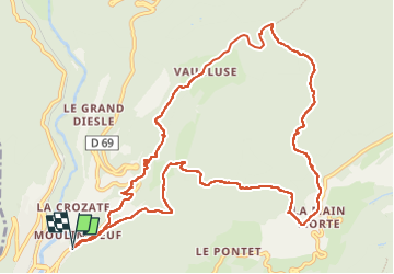
Randonnée Marche de 12,9 km à découvrir à Bourgogne-Franche-Comté, Jura, Saint-Claude. Cette randonnée est proposée par Greg813.
Description
Randonnée avec Mettons le Monde en Marche aux environs de St Claude.
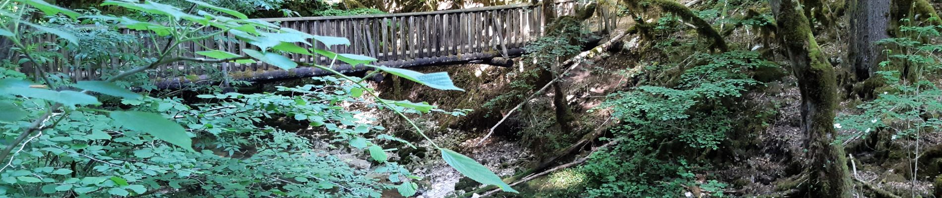
Débutant par une remontée du ruisseau de l'Abime jusqu'au belvédère du Crêt Pourri offrant une vue panoramique sur la vallée.
Pour d'autres photos, voir le site de l'association :
https://mmm-rando.org/le-haut-jura-en-etoile/
Localisation
Commentaires
Randonnées à proximité
![Randonnée Marche Septmoncel les Molunes - circuit des chamois Septmoncel - Photo](https://media.geolcdn.com/t/375/260/ext.jpg?maxdim=2&url=https%3A%2F%2Fservices.sitytrail.com%2FGeolivesWS%2FDownloadMedia.ashx%3FTrailID%3D799248%26Media%3D20170730174922.jpg)
![Marche Marche](https://static1.geolcdn.com/sitytour/trail-icons/101.png)
Marche
![](/images/other/stat-length.png)
![](https://static1.geolcdn.com/siteimages/upload/files/16400158638029165_repeat_loop_refresh_sync_direction_icon.png)
![Randonnée Marche Septmoncel les Molunes - mo sentier des lapidaires - Photo](https://media.geolcdn.com/t/375/260/3ce9e642-8b27-4197-a9db-76cbf671243e.jpg&format=jpg&maxdim=2)
![Marche Marche](https://static1.geolcdn.com/sitytour/trail-icons/101.png)
Marche
![](/images/other/stat-length.png)
![](https://static1.geolcdn.com/siteimages/upload/files/16400158638029165_repeat_loop_refresh_sync_direction_icon.png)
![Randonnée Course à pied Saint-Claude - UTTJ 2015-1 - Photo](https://media.geolcdn.com/t/375/260/ext.jpg?maxdim=2&url=https%3A%2F%2Fstatic1.geolcdn.com%2Fsiteimages%2Fupload%2Ffiles%2F1524743154running.jpg)
![Course à pied Course à pied](https://static1.geolcdn.com/sitytour/trail-icons/103.png)
Course à pied
![](/images/other/stat-length.png)
![](https://static1.geolcdn.com/siteimages/upload/files/16400158638029165_repeat_loop_refresh_sync_direction_icon.png)
![Randonnée Marche Villard-Saint-Sauveur - cascade de flumen - saut du chien - retour en partie par la route - Photo](https://media.geolcdn.com/t/375/260/677bfeb9-5daf-421e-aba3-7eb72ae37d4d.jpg&format=jpg&maxdim=2)
![Marche Marche](https://static1.geolcdn.com/sitytour/trail-icons/101.png)
Marche
![](/images/other/stat-length.png)
![](https://static1.geolcdn.com/siteimages/upload/files/16400158638029165_repeat_loop_refresh_sync_direction_icon.png)
![Randonnée Marche Villard-Saint-Sauveur - Pont de l'Isle - cascade queue de cheval - Photo](https://media.geolcdn.com/t/375/260/3189b139-82f8-4327-afd3-bc3510f0244f.jpg&format=jpg&maxdim=2)
![Marche Marche](https://static1.geolcdn.com/sitytour/trail-icons/101.png)
Marche
![](/images/other/stat-length.png)
![](https://static1.geolcdn.com/siteimages/upload/files/16400158638029165_repeat_loop_refresh_sync_direction_icon.png)
![Randonnée Marche Saint-Claude - Belvd. Pontoux depuis Rue des Perrieres à St-Claude 39200 - Photo](https://media.geolcdn.com/t/375/260/f9b19760-1bb3-48d6-b56c-4ed1797baa03.jpg&format=jpg&maxdim=2)
![Marche Marche](https://static1.geolcdn.com/sitytour/trail-icons/101.png)
Marche
![](/images/other/stat-length.png)
![](https://static1.geolcdn.com/siteimages/upload/files/16400158638029165_repeat_loop_refresh_sync_direction_icon.png)
![Randonnée Marche Saint-Claude - St Claude Cascade de la Vouivre - Photo](https://media.geolcdn.com/t/375/260/223568e4-ca44-4832-866a-614785810ad8.jpg&format=jpg&maxdim=2)
![Marche Marche](https://static1.geolcdn.com/sitytour/trail-icons/101.png)
Marche
![](/images/other/stat-length.png)
![](https://static1.geolcdn.com/siteimages/upload/files/16400158638029165_repeat_loop_refresh_sync_direction_icon.png)
![Randonnée Marche Saint-Claude - De St-Claude à Vaucluse - Photo](https://media.geolcdn.com/t/375/260/6f07c1ae-93f7-4e21-bedc-a3f02b9c3c40.jpg&format=jpg&maxdim=2)
![Marche Marche](https://static1.geolcdn.com/sitytour/trail-icons/101.png)
Marche
![](/images/other/stat-length.png)
![](https://static1.geolcdn.com/siteimages/upload/files/16400158638029165_repeat_loop_refresh_sync_direction_icon.png)
![Randonnée Marche Saint-Claude - queue de l'âne et queue de cheval - Photo](https://media.geolcdn.com/t/375/260/e5f2c5fa-1331-420e-8d70-7e16d12492d0.jpg&format=jpg&maxdim=2)
![Marche Marche](https://static1.geolcdn.com/sitytour/trail-icons/101.png)
Marche
![](/images/other/stat-length.png)
![](https://static1.geolcdn.com/siteimages/upload/files/16400158638029165_repeat_loop_refresh_sync_direction_icon.png)