![](/images/other/stat-length.png)
![Randonnée Marche Hon-Hergies - Circuit du Bois Verdiau - Photo](https://media.geolcdn.com/t/1900/400/ext.pjpeg?maxdim=2&url=https%3A%2F%2Fstatic1.geolcdn.com%2Fsiteimages%2Fupload%2Ffiles%2F1553511878bg_sport_marche.png)
Circuit du Bois Verdiau
corsinou
Utilisateur
![Longueur](/images/other/stat-length.png)
Longueur
10,4 km
![Altitude max](https://static1.geolcdn.com/siteimages/upload/files/1508320355ic_sort_altitude_max_24dp.png)
Altitude max
151 m
![Dénivelé positif](https://static1.geolcdn.com/siteimages/upload/files/1508320355ic_sort_den_pos_24dp.png)
Dénivelé positif
107 m
![Km-Effort](/images/other/stat-length.png)
Km-Effort
11,8 km
![Altitude min](https://static1.geolcdn.com/siteimages/upload/files/1508320355ic_sort_altitude_min_24dp.png)
Altitude min
107 m
![Dénivelé négatif](https://static1.geolcdn.com/siteimages/upload/files/1508320355ic_sort_den_neg_24dp.png)
Dénivelé négatif
107 m
![Boucle](https://static1.geolcdn.com/siteimages/upload/files/16400158638029165_repeat_loop_refresh_sync_direction_icon.png)
Boucle
Oui
Date de création :
2014-12-10 00:00:00.0
Dernière modification :
2014-12-10 00:00:00.0
![Marche](https://static1.geolcdn.com/sitytour/trail-icons/101.png)
2h34
Difficulté : Inconnu
![Scannez ce code QR pour ouvrir la randonnée dans l'application SityTrail](https://capi.geolives.com/qq0zvz2zws4bq2lad0pu/sitytour/trails/325897/qr.png?size=200)
Application GPS de randonnée GRATUITE
À propos
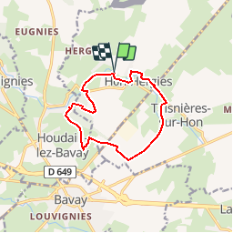
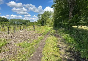
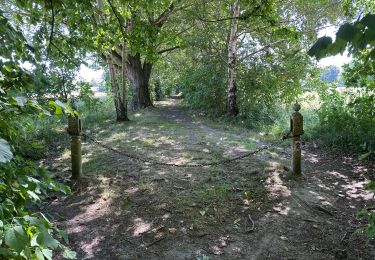
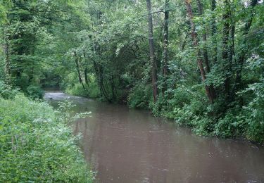
Randonnée Marche de 10,4 km à découvrir à Hauts-de-France, Nord, Hon-Hergies. Cette randonnée est proposée par corsinou.
Description
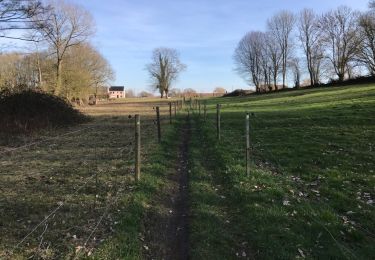
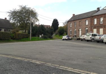
Au départ du bar brasserie Le Jardin des Pêcheurs, petite rand sans difficulté en empruntant les chemins forestiers du bois Verdiau
restauration possible au Jardins Des Pêcheurs à l'arrivée
Localisation
Pays :
France
Région :
Hauts-de-France
Département/Province :
Nord
Commune :
Hon-Hergies
Localité :
Unknown
Départ:(Dec)
Départ:(UTM)
557772 ; 5575499 (31U) N.
Commentaires
Randonnées à proximité
![Randonnée Marche Bettrechies - Balisage des Carriers automne - Photo](https://media.geolcdn.com/t/375/260/ext.jpg?maxdim=2&url=https%3A%2F%2Fmedia.geolcdn.com%2Ff%2Fafb2b495-a39b-4963-8124-af71875418da.jpg)
![Marche Marche](https://static1.geolcdn.com/sitytour/trail-icons/101.png)
Balisage des Carriers automne
Marche
Très facile
(2)
Bettrechies,
Hauts-de-France,
Nord,
France
![](/images/other/stat-length.png)
6,1 km | 7,2 km-effort
2h 1min
![](https://static1.geolcdn.com/siteimages/upload/files/16400158638029165_repeat_loop_refresh_sync_direction_icon.png)
Oui
![Randonnée Marche Honnelles - RB-Ha-14 - Athis - Via allongement - Photo](https://media.geolcdn.com/t/375/260/ext.jpg?maxdim=2&url=https%3A%2F%2Fservices.sitytrail.com%2FGeolivesWS%2FDownloadMedia.ashx%3FTrailID%3D220103%26Media%3Dfd0451b6-4a73-497a-b080-d1f7d1bb147b.jpg)
![Marche Marche](https://static1.geolcdn.com/sitytour/trail-icons/101.png)
RB-Ha-14 - Athis - Via allongement
Marche
Très difficile
Honnelles,
Wallonie,
Hainaut,
Belgique
![](/images/other/stat-length.png)
22 km | 26 km-effort
5h 49min
![](https://static1.geolcdn.com/siteimages/upload/files/16400158638029165_repeat_loop_refresh_sync_direction_icon.png)
Oui
![Randonnée Marche Honnelles - RB-Ha-14 - Athis - Photo](https://media.geolcdn.com/t/375/260/ext.jpg?maxdim=2&url=https%3A%2F%2Fservices.sitytrail.com%2FGeolivesWS%2FDownloadMedia.ashx%3FTrailID%3D179608%26Media%3Dfd0451b6-4a73-497a-b080-d1f7d1bb147b.jpg)
![Marche Marche](https://static1.geolcdn.com/sitytour/trail-icons/101.png)
RB-Ha-14 - Athis
Marche
Très difficile
(3)
Honnelles,
Wallonie,
Hainaut,
Belgique
![](/images/other/stat-length.png)
18,6 km | 21 km-effort
4h 52min
![](https://static1.geolcdn.com/siteimages/upload/files/16400158638029165_repeat_loop_refresh_sync_direction_icon.png)
Oui
![Randonnée Marche Hon-Hergies - Circuit des machines anciennes - Hon-Hergies - Photo](https://media.geolcdn.com/t/375/260/ext.jpg?maxdim=2&url=https%3A%2F%2Fstatic1.geolcdn.com%2Fsiteimages%2Fupload%2Ffiles%2F1553511878bg_sport_marche.png)
![Marche Marche](https://static1.geolcdn.com/sitytour/trail-icons/101.png)
Circuit des machines anciennes - Hon-Hergies
Marche
Facile
(2)
Hon-Hergies,
Hauts-de-France,
Nord,
France
![](/images/other/stat-length.png)
8,5 km | 9,5 km-effort
2h 10min
![](https://static1.geolcdn.com/siteimages/upload/files/16400158638029165_repeat_loop_refresh_sync_direction_icon.png)
Oui
![Randonnée Marche Honnelles - Fayt le Franc - Le Caillou qui bique 18km - Photo](https://media.geolcdn.com/t/375/260/ext.jpg?maxdim=2&url=https%3A%2F%2Fmedia.geolcdn.com%2Ff%2Fd70247f0-3d61-4d84-9a66-6e3d72469a64.jpg)
![Marche Marche](https://static1.geolcdn.com/sitytour/trail-icons/101.png)
Fayt le Franc - Le Caillou qui bique 18km
Marche
Moyen
Honnelles,
Wallonie,
Hainaut,
Belgique
![](/images/other/stat-length.png)
18,2 km | 21 km-effort
5h 49min
![](https://static1.geolcdn.com/siteimages/upload/files/16400158638029165_repeat_loop_refresh_sync_direction_icon.png)
Oui
![Randonnée Marche Frameries - SARS les Bruyère 17 km - Photo](https://media.geolcdn.com/t/375/260/ext.jpg?maxdim=2&url=https%3A%2F%2Fmedia.geolcdn.com%2Ff%2F0902d9c1-b9bd-474f-82c3-5d5d7e4f7743.jpg)
![Marche Marche](https://static1.geolcdn.com/sitytour/trail-icons/101.png)
SARS les Bruyère 17 km
Marche
Facile
Frameries,
Wallonie,
Hainaut,
Belgique
![](/images/other/stat-length.png)
17,3 km | 19,7 km-effort
4h 56min
![](https://static1.geolcdn.com/siteimages/upload/files/16400158638029165_repeat_loop_refresh_sync_direction_icon.png)
Oui
![Randonnée A pied Bettrechies - La pierre, or bleu de la vallée du marbre - Photo](https://media.geolcdn.com/t/375/260/ext.jpg?maxdim=2&url=https%3A%2F%2Fmedia.geolcdn.com%2Ff%2F53843257-a333-4895-a5c4-b673a2032b5c.jpeg)
![A pied A pied](https://static1.geolcdn.com/sitytour/trail-icons/100.png)
La pierre, or bleu de la vallée du marbre
A pied
Facile
(1)
Bettrechies,
Hauts-de-France,
Nord,
France
![](/images/other/stat-length.png)
6 km | 7,3 km-effort
1h 39min
![](https://static1.geolcdn.com/siteimages/upload/files/16400158638029165_repeat_loop_refresh_sync_direction_icon.png)
Oui
![Randonnée Marche Frameries - 18 km Sars-Seuwartan - Photo](https://media.geolcdn.com/t/375/260/ext.jpg?maxdim=2&url=https%3A%2F%2Fmedia.geolcdn.com%2Ff%2F3d2b7b37-8e82-4edb-890e-e4262ea97925.jpg)
![Marche Marche](https://static1.geolcdn.com/sitytour/trail-icons/101.png)
18 km Sars-Seuwartan
Marche
Moyen
Frameries,
Wallonie,
Hainaut,
Belgique
![](/images/other/stat-length.png)
17,8 km | 21 km-effort
3h 7min
![](https://static1.geolcdn.com/siteimages/upload/files/16400158638029165_repeat_loop_refresh_sync_direction_icon.png)
Oui
![Randonnée Marche Dour - Blaugies 23 km - Photo](https://media.geolcdn.com/t/375/260/ext.jpg?maxdim=2&url=https%3A%2F%2Fservices.sitytrail.com%2FGeolivesWS%2FDownloadMedia.ashx%3FTrailID%3D1111723%26Media%3D20190217154258.jpg)
![Marche Marche](https://static1.geolcdn.com/sitytour/trail-icons/101.png)