![](/images/other/stat-length.png)
![Randonnée Marche La Louvière - La balade des ascenseurs - Houdeng-Aimeries - Photo](https://media.geolcdn.com/t/1900/400/d99da6dd-7e06-432a-8742-a2cbb7aa82e8.jpeg&format=pjpeg&maxdim=2)
La balade des ascenseurs - Houdeng-Aimeries
Desrumaux
Utilisateur GUIDE
![Longueur](/images/other/stat-length.png)
Longueur
8 km
![Altitude max](https://static1.geolcdn.com/siteimages/upload/files/1508320355ic_sort_altitude_max_24dp.png)
Altitude max
116 m
![Dénivelé positif](https://static1.geolcdn.com/siteimages/upload/files/1508320355ic_sort_den_pos_24dp.png)
Dénivelé positif
86 m
![Km-Effort](/images/other/stat-length.png)
Km-Effort
9,1 km
![Altitude min](https://static1.geolcdn.com/siteimages/upload/files/1508320355ic_sort_altitude_min_24dp.png)
Altitude min
72 m
![Dénivelé négatif](https://static1.geolcdn.com/siteimages/upload/files/1508320355ic_sort_den_neg_24dp.png)
Dénivelé négatif
83 m
![Boucle](https://static1.geolcdn.com/siteimages/upload/files/16400158638029165_repeat_loop_refresh_sync_direction_icon.png)
Boucle
Oui
Date de création :
2022-05-22 09:26:19.446
Dernière modification :
2022-06-17 13:28:48.094
![Marche](https://static1.geolcdn.com/sitytour/trail-icons/101.png)
3h42
Difficulté : Moyen
![Scannez ce code QR pour ouvrir la randonnée dans l'application SityTrail](https://capi.geolives.com/qq0zvz2zws4bq2lad0pu/sitytour/trails/3252556/qr.png?size=200)
Application GPS de randonnée GRATUITE
À propos
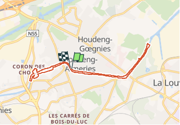
Randonnée Marche de 8 km à découvrir à Wallonie, Hainaut, La Louvière. Cette randonnée est proposée par Desrumaux.
Description
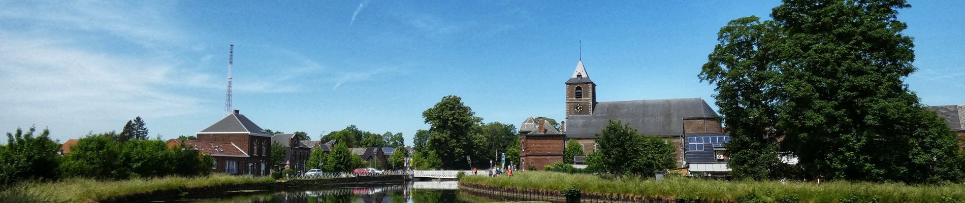
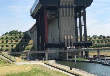
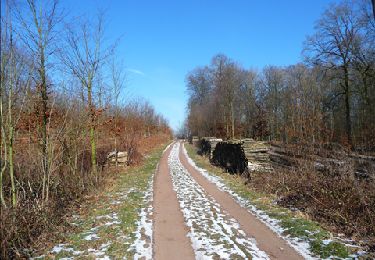
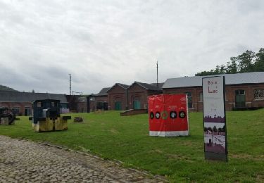
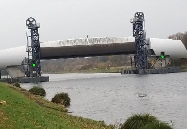
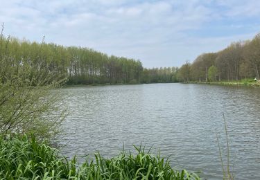
Relaxante balade au fil de l’ancien canal du centre au départ de l’église du village de Houdeng-Aimeries dans l’entité de La Louvière,province du Hainaut, Belgique.
Localisation
Pays :
Belgique
Région :
Wallonie
Département/Province :
Hainaut
Commune :
La Louvière
Localité :
Unknown
Départ:(Dec)
Départ:(UTM)
581549 ; 5592907 (31U) N.
Commentaires
Randonnées à proximité
![Randonnée Marche Le Rœulx - Thieu Strepy nouveau et ancien canal 15km - Photo](https://media.geolcdn.com/t/375/260/4ab1d82d-037a-45cc-b066-dd8dceb68df8.jpeg&format=jpg&maxdim=2)
![Marche Marche](https://static1.geolcdn.com/sitytour/trail-icons/101.png)
Thieu Strepy nouveau et ancien canal 15km
Marche
Facile
(1)
Le Rœulx,
Wallonie,
Hainaut,
Belgique
![](/images/other/stat-length.png)
15,2 km | 17,4 km-effort
3h 50min
![](https://static1.geolcdn.com/siteimages/upload/files/16400158638029165_repeat_loop_refresh_sync_direction_icon.png)
Oui
![Randonnée Marche Le Rœulx - Balade champêtre au Roeulx - Photo](https://media.geolcdn.com/t/375/260/ext.jpg?maxdim=2&url=https%3A%2F%2Fservices.sitytrail.com%2FGeolivesWS%2FDownloadMedia.ashx%3FTrailID%3D108082%26Media%3D0713eccb-7649-4b02-8bb5-985a3300c10f.JPG)
![Marche Marche](https://static1.geolcdn.com/sitytour/trail-icons/101.png)
Balade champêtre au Roeulx
Marche
Facile
(1)
Le Rœulx,
Wallonie,
Hainaut,
Belgique
![](/images/other/stat-length.png)
10,9 km | 12,8 km-effort
2h 40min
![](https://static1.geolcdn.com/siteimages/upload/files/16400158638029165_repeat_loop_refresh_sync_direction_icon.png)
Oui
![Randonnée Vélo La Louvière - Cantine des Italiens-Canal du centre-Bois du Luc - Photo](https://media.geolcdn.com/t/375/260/ext.jpg?maxdim=2&url=https%3A%2F%2Fservices.sitytrail.com%2FGeolivesWS%2FDownloadMedia.ashx%3FTrailID%3D797348%26Media%3Dfix__20170727115839.jpg)
![Vélo Vélo](https://static1.geolcdn.com/sitytour/trail-icons/200.png)
Cantine des Italiens-Canal du centre-Bois du Luc
Vélo
Facile
(3)
La Louvière,
Wallonie,
Hainaut,
Belgique
![](/images/other/stat-length.png)
31 km | 35 km-effort
2h 1min
![](https://static1.geolcdn.com/siteimages/upload/files/16400158638029165_repeat_loop_refresh_sync_direction_icon.png)
Oui
![Randonnée Vélo La Louvière - Ascenseurs du Centre Strepy Thieu Bracquenies - Photo](https://media.geolcdn.com/t/375/260/ext.jpg?maxdim=2&url=https%3A%2F%2Fservices.sitytrail.com%2FGeolivesWS%2FDownloadMedia.ashx%3FTrailID%3D1074392%26Media%3Dfix__20181120130643.jpg)
![Vélo Vélo](https://static1.geolcdn.com/sitytour/trail-icons/200.png)
Ascenseurs du Centre Strepy Thieu Bracquenies
Vélo
Facile
(1)
La Louvière,
Wallonie,
Hainaut,
Belgique
![](/images/other/stat-length.png)
18,5 km | 22 km-effort
3h 7min
![](https://static1.geolcdn.com/siteimages/upload/files/16400158638029165_repeat_loop_refresh_sync_direction_icon.png)
Oui
![Randonnée Marche La Louvière - A la découverte du Canal du Centre - Houdeng Aimeries - Photo](https://media.geolcdn.com/t/375/260/ext.jpg?maxdim=2&url=https%3A%2F%2Fstatic1.geolcdn.com%2Fsiteimages%2Fupload%2Ffiles%2F1553511878bg_sport_marche.png)
![Marche Marche](https://static1.geolcdn.com/sitytour/trail-icons/101.png)
A la découverte du Canal du Centre - Houdeng Aimeries
Marche
Facile
(4)
La Louvière,
Wallonie,
Hainaut,
Belgique
![](/images/other/stat-length.png)
12,9 km | 15,4 km-effort
3h 0min
![](https://static1.geolcdn.com/siteimages/upload/files/16400158638029165_repeat_loop_refresh_sync_direction_icon.png)
Oui
![Randonnée Marche Le Rœulx - BE-Le Roeulx - La Haye du Roeulx - Domaine Aldo Vastapane - W - Photo](https://media.geolcdn.com/t/375/260/dd72392e-02a4-40c7-936e-9b75c105e7f1.jpg&format=jpg&maxdim=2)
![Marche Marche](https://static1.geolcdn.com/sitytour/trail-icons/101.png)
BE-Le Roeulx - La Haye du Roeulx - Domaine Aldo Vastapane - W
Marche
Moyen
Le Rœulx,
Wallonie,
Hainaut,
Belgique
![](/images/other/stat-length.png)
6,4 km | 7,5 km-effort
1h 41min
![](https://static1.geolcdn.com/siteimages/upload/files/16400158638029165_repeat_loop_refresh_sync_direction_icon.png)
Oui
![V.T.T. V.T.T.](https://static1.geolcdn.com/sitytour/trail-icons/202.png)
VTT autour de Thieu et les terril.
V.T.T.
Très difficile
Le Rœulx,
Wallonie,
Hainaut,
Belgique
![](/images/other/stat-length.png)
49 km | 57 km-effort
3h 58min
![](https://static1.geolcdn.com/siteimages/upload/files/16400158638029165_repeat_loop_refresh_sync_direction_icon.png)
Non
![Randonnée Marche La Louvière - Strépy-Bracquegnies - Canal et Ascenseur n°1 - Photo](https://media.geolcdn.com/t/375/260/ext.jpg?maxdim=2&url=https%3A%2F%2Fstatic1.geolcdn.com%2Fsiteimages%2Fupload%2Ffiles%2F1553511878bg_sport_marche.png)
![Marche Marche](https://static1.geolcdn.com/sitytour/trail-icons/101.png)
Strépy-Bracquegnies - Canal et Ascenseur n°1
Marche
Moyen
(2)
La Louvière,
Wallonie,
Hainaut,
Belgique
![](/images/other/stat-length.png)
8,8 km | 10,1 km-effort
2h 17min
![](https://static1.geolcdn.com/siteimages/upload/files/16400158638029165_repeat_loop_refresh_sync_direction_icon.png)
Oui
![Randonnée Marche La Louvière - Etincelle - Photo](https://media.geolcdn.com/t/375/260/ext.jpg?maxdim=2&url=https%3A%2F%2Fstatic1.geolcdn.com%2Fsiteimages%2Fupload%2Ffiles%2F1553511878bg_sport_marche.png)
![Marche Marche](https://static1.geolcdn.com/sitytour/trail-icons/101.png)
Etincelle
Marche
Très facile
(1)
La Louvière,
Wallonie,
Hainaut,
Belgique
![](/images/other/stat-length.png)
9,9 km | 11,3 km-effort
2h 29min
![](https://static1.geolcdn.com/siteimages/upload/files/16400158638029165_repeat_loop_refresh_sync_direction_icon.png)
Oui