![](/images/other/stat-length.png)
![Randonnée Marche Thiéry - Pointe de Chavanette Par chapelle Ste Madeleine/Thiery - Photo](https://media.geolcdn.com/t/1900/400/bf4c4b25-1f2c-4c16-b282-1fd0acf4f8e0.jpg&format=pjpeg&maxdim=2)
Pointe de Chavanette Par chapelle Ste Madeleine/Thiery
GrouGary
Utilisateur
![Longueur](/images/other/stat-length.png)
![Altitude max](https://static1.geolcdn.com/siteimages/upload/files/1508320355ic_sort_altitude_max_24dp.png)
![Dénivelé positif](https://static1.geolcdn.com/siteimages/upload/files/1508320355ic_sort_den_pos_24dp.png)
![Km-Effort](/images/other/stat-length.png)
![Altitude min](https://static1.geolcdn.com/siteimages/upload/files/1508320355ic_sort_altitude_min_24dp.png)
![Dénivelé négatif](https://static1.geolcdn.com/siteimages/upload/files/1508320355ic_sort_den_neg_24dp.png)
![Boucle](https://static1.geolcdn.com/siteimages/upload/files/16400158638029165_repeat_loop_refresh_sync_direction_icon.png)
![Marche](https://static1.geolcdn.com/sitytour/trail-icons/101.png)
4h47
Difficulté : Moyen
![Scannez ce code QR pour ouvrir la randonnée dans l'application SityTrail](https://capi.geolives.com/qq0zvz2zws4bq2lad0pu/sitytour/trails/3252386/qr.png?size=200)
Application GPS de randonnée GRATUITE
À propos
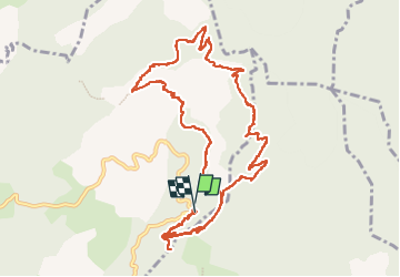
Randonnée Marche de 14,4 km à découvrir à Provence-Alpes-Côte d'Azur, Alpes-Maritimes, Thiéry. Cette randonnée est proposée par GrouGary.
Description
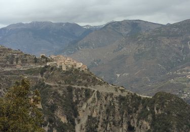
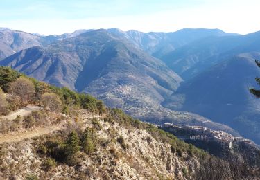
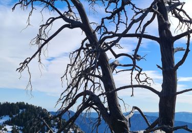
Boucle à partir de la route qui monte à Thiery. Au niveau du ravin de la Duina, monter la piste jusqu'à la chapelle Ste Madeleine. Emprunter le chemin du GR 510 sur 10-20 mètres puis prendre à gauche le petit sentier en partie masqué par les genêts. Suivre le balisage jaune du sentier qui monte sous couvert forestier. Lorsqu'on atteint la vacherie entièrement refaite, monter droit dans les asphodèles très nombreuses fin mai, en vous guidant aussi sur les cairns. Prendre son temps pour ne pas perdre le petit sentier. Au niveau de la ligne pointillée de la Baisse des 4 cantons, continuer jusqu'à passer un col (beaux rochers). Le sentier descend pour atteindre peu après une "pelouse" en lisière de forêt, face à la pointe de chavanette et au Mercantour encore un peu enneigé. Pause pic-nic... trop bien. Petit détour sur le sommet de chavanette pour apercevoir le col de Courbaisse.
Contourner la pointe de chavanette en revenant un peu sur nos pas, tout en descendant.
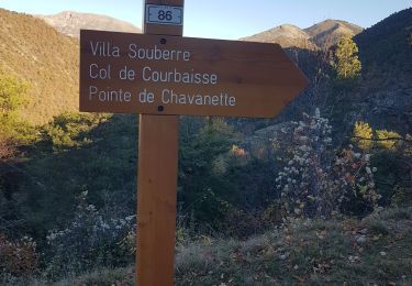
Petit passage rocheux que l'on peut éviter en contournant sur la droite... Entrée dans le bois et arrivée au col de Courbaisse.
A la balise 216, prendre le sentier qui descend en sous-bois pour rejoindre le GR 510 avant la villa souberre.
Le GR 510 a été endommagé lors de la tempête Alex au niveau des talwegs mais certains passages ont été aménagés (ne pas craindre)
Localisation
Commentaires
Randonnées à proximité
![Randonnée A pied Bairols - Tour du mont Falourde - Photo](https://media.geolcdn.com/t/375/260/72458cd6-de82-448d-8f0e-f50b00abdc54.jpeg&format=jpg&maxdim=2)
![A pied A pied](https://static1.geolcdn.com/sitytour/trail-icons/100.png)
A pied
![](/images/other/stat-length.png)
![](https://static1.geolcdn.com/siteimages/upload/files/16400158638029165_repeat_loop_refresh_sync_direction_icon.png)
![Randonnée A pied Massoins - Plateau du Lac - Photo](https://media.geolcdn.com/t/375/260/72458cd6-de82-448d-8f0e-f50b00abdc54.jpeg&format=jpg&maxdim=2)
![A pied A pied](https://static1.geolcdn.com/sitytour/trail-icons/100.png)
A pied
![](/images/other/stat-length.png)
![](https://static1.geolcdn.com/siteimages/upload/files/16400158638029165_repeat_loop_refresh_sync_direction_icon.png)
![Randonnée Marche Thiéry - Brec d’ Ilonse - Photo](https://media.geolcdn.com/t/375/260/371e8790-f558-4bbf-8168-94a56f4b21b9.jpg&format=jpg&maxdim=2)
![Marche Marche](https://static1.geolcdn.com/sitytour/trail-icons/101.png)
Marche
![](/images/other/stat-length.png)
![](https://static1.geolcdn.com/siteimages/upload/files/16400158638029165_repeat_loop_refresh_sync_direction_icon.png)
![Randonnée Marche Bairols - Pointe des 4 Cantons - Photo](https://media.geolcdn.com/t/375/260/a7a9d005-3907-43b9-a75f-ead216069129.jpg&format=jpg&maxdim=2)
![Marche Marche](https://static1.geolcdn.com/sitytour/trail-icons/101.png)
Marche
![](/images/other/stat-length.png)
![](https://static1.geolcdn.com/siteimages/upload/files/16400158638029165_repeat_loop_refresh_sync_direction_icon.png)
![Randonnée Marche Thiéry - thiery Villa Soubere - Photo](https://media.geolcdn.com/t/375/260/152e54b1-7917-4f58-90c1-fbc432530c5c.jpg&format=jpg&maxdim=2)
![Marche Marche](https://static1.geolcdn.com/sitytour/trail-icons/101.png)
Marche
![](/images/other/stat-length.png)
![](https://static1.geolcdn.com/siteimages/upload/files/16400158638029165_repeat_loop_refresh_sync_direction_icon.png)
![Randonnée Marche Bairols - Mont Falourde depuis Bairoldmd - Photo](https://media.geolcdn.com/t/375/260/ee8fbd45-d346-4d87-a199-f1064cf2e4bd.jpg&format=jpg&maxdim=2)
![Marche Marche](https://static1.geolcdn.com/sitytour/trail-icons/101.png)
Marche
![](/images/other/stat-length.png)
![](https://static1.geolcdn.com/siteimages/upload/files/16400158638029165_repeat_loop_refresh_sync_direction_icon.png)
![Randonnée Marche Bairols - Pointe des 4 cantons de Bairols retour col de l'espella - Photo](https://media.geolcdn.com/t/375/260/f66efb90-77ab-4307-b314-11309c7279a0.jpg&format=jpg&maxdim=2)
![Marche Marche](https://static1.geolcdn.com/sitytour/trail-icons/101.png)
Marche
![](/images/other/stat-length.png)
![](https://static1.geolcdn.com/siteimages/upload/files/16400158638029165_repeat_loop_refresh_sync_direction_icon.png)
![Randonnée Marche Lieuche - Lieuche brec d ilonse - Photo](https://media.geolcdn.com/t/375/260/b5e77ab5-d74f-4c03-aaca-8053a1eeae4f.jpg&format=jpg&maxdim=2)
![Marche Marche](https://static1.geolcdn.com/sitytour/trail-icons/101.png)
Marche
![](/images/other/stat-length.png)
![](https://static1.geolcdn.com/siteimages/upload/files/16400158638029165_repeat_loop_refresh_sync_direction_icon.png)
![Randonnée Marche Thiéry - mont fracha et brec d illons - Photo](https://media.geolcdn.com/t/375/260/7a352f20-95c8-4db5-abd7-afa376ae4d13.jpg&format=jpg&maxdim=2)
![Marche Marche](https://static1.geolcdn.com/sitytour/trail-icons/101.png)
Marche
![](/images/other/stat-length.png)
![](https://static1.geolcdn.com/siteimages/upload/files/16400158638029165_repeat_loop_refresh_sync_direction_icon.png)