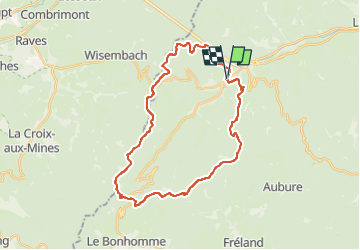
![](/images/other/stat-length.png)
![Randonnée Marche Sainte-Marie-aux-Mines - Tour de Ste Marie en 2 jours - Photo](https://media.geolcdn.com/t/1900/400/ext.pjpeg?maxdim=2&url=https%3A%2F%2Fstatic1.geolcdn.com%2Fsiteimages%2Fupload%2Ffiles%2F1553511878bg_sport_marche.png)
Tour de Ste Marie en 2 jours
patandre
Utilisateur
![Longueur](/images/other/stat-length.png)
![Altitude max](https://static1.geolcdn.com/siteimages/upload/files/1508320355ic_sort_altitude_max_24dp.png)
![Dénivelé positif](https://static1.geolcdn.com/siteimages/upload/files/1508320355ic_sort_den_pos_24dp.png)
![Km-Effort](/images/other/stat-length.png)
![Altitude min](https://static1.geolcdn.com/siteimages/upload/files/1508320355ic_sort_altitude_min_24dp.png)
![Dénivelé négatif](https://static1.geolcdn.com/siteimages/upload/files/1508320355ic_sort_den_neg_24dp.png)
![Boucle](https://static1.geolcdn.com/siteimages/upload/files/16400158638029165_repeat_loop_refresh_sync_direction_icon.png)
![Marche](https://static1.geolcdn.com/sitytour/trail-icons/101.png)
11h00
Difficulté : Très difficile
![Scannez ce code QR pour ouvrir la randonnée dans l'application SityTrail](https://capi.geolives.com/qq0zvz2zws4bq2lad0pu/sitytour/trails/3247471/qr.png?size=200)
Application GPS de randonnée GRATUITE
À propos
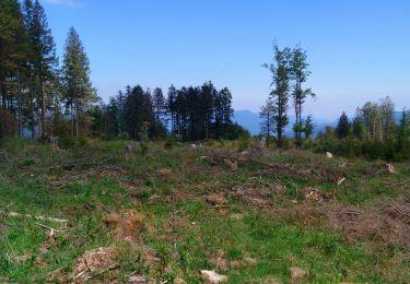
Randonnée Marche de 30 km à découvrir à Grand Est, Haut-Rhin, Sainte-Marie-aux-Mines. Cette randonnée est proposée par patandre.
Description
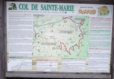
Jour 1 = Ste Marie - Croix de Mission - Grand Plaine - Abri du Robinot - Col de Ste Marie - Arbre de la Liberté - Col du Pré de Raves - Col des Bagenelles, soit 16,5 kms - 6 heures
Jour 2 : Haycot - Petit Brésouard - Pierre des Trois Bans - Tertre de la Fille Morte - Hermanshütte - Blumenthal - Ste Marie, soit 14 kms - 5 heures
Localisation
Commentaires
Randonnées à proximité
![Randonnée Marche Sainte-Marie-aux-Mines - 2020-06-20 Marche Tete du Violu Col de Ste Marie - Photo](https://media.geolcdn.com/t/375/260/d44ae4f7-8944-4d5a-a40f-b5db5e1cd846.jpg&format=jpg&maxdim=2)
![Marche Marche](https://static1.geolcdn.com/sitytour/trail-icons/101.png)
Marche
![](/images/other/stat-length.png)
![](https://static1.geolcdn.com/siteimages/upload/files/16400158638029165_repeat_loop_refresh_sync_direction_icon.png)
![Randonnée Marche Sainte-Marie-aux-Mines - la croix de Ribeauvillé - Photo](https://media.geolcdn.com/t/375/260/d5b1ea95-9e8b-4e75-bd59-dd918afbb44b.jpg&format=jpg&maxdim=2)
![Marche Marche](https://static1.geolcdn.com/sitytour/trail-icons/101.png)
Marche
![](/images/other/stat-length.png)
![](https://static1.geolcdn.com/siteimages/upload/files/16400158638029165_repeat_loop_refresh_sync_direction_icon.png)
![Randonnée Marche Sainte-Marie-aux-Mines - taenichel - Photo](https://media.geolcdn.com/t/375/260/f89cec21-9478-4217-bf8a-15cadae40096.jpg&format=jpg&maxdim=2)
![Marche Marche](https://static1.geolcdn.com/sitytour/trail-icons/101.png)
Marche
![](/images/other/stat-length.png)
![](https://static1.geolcdn.com/siteimages/upload/files/16400158638029165_repeat_loop_refresh_sync_direction_icon.png)
![Randonnée Marche Sainte-Marie-aux-Mines - Col du Haut de Ribeauvillé - Rochers des Géants (Rother n°31) - Photo](https://media.geolcdn.com/t/375/260/cfbc15a6-3f32-42dc-813b-8bce71fe94c9.jpg&format=jpg&maxdim=2)
![Marche Marche](https://static1.geolcdn.com/sitytour/trail-icons/101.png)
Marche
![](/images/other/stat-length.png)
![](https://static1.geolcdn.com/siteimages/upload/files/16400158638029165_repeat_loop_refresh_sync_direction_icon.png)
![Randonnée Marche Sainte-Marie-aux-Mines - rocher des chèvred - Photo](https://media.geolcdn.com/t/375/260/1ee03ea7-dcc4-4aab-8946-92ada103a5f7.jpg&format=jpg&maxdim=2)
![Marche Marche](https://static1.geolcdn.com/sitytour/trail-icons/101.png)
Marche
![](/images/other/stat-length.png)
![](https://static1.geolcdn.com/siteimages/upload/files/16400158638029165_repeat_loop_refresh_sync_direction_icon.png)
![Randonnée Marche Gemaingoutte - col Sainte Marie aux mines - Photo](https://media.geolcdn.com/t/375/260/644b77d8-a894-4e68-a040-8ae35dcbcebd.jpg&format=jpg&maxdim=2)
![Marche Marche](https://static1.geolcdn.com/sitytour/trail-icons/101.png)
Marche
![](/images/other/stat-length.png)
![](https://static1.geolcdn.com/siteimages/upload/files/16400158638029165_repeat_loop_refresh_sync_direction_icon.png)
![Randonnée Marche Sainte-Marie-aux-Mines - Crête granitique et forêts profondes - Photo](https://media.geolcdn.com/t/375/260/cdc1fd69-bfc3-4d29-b7a2-7dbb2d83ce85.jpg&format=jpg&maxdim=2)
![Marche Marche](https://static1.geolcdn.com/sitytour/trail-icons/101.png)
Marche
![](/images/other/stat-length.png)
![](https://static1.geolcdn.com/siteimages/upload/files/16400158638029165_repeat_loop_refresh_sync_direction_icon.png)
![Randonnée Marche Sainte-Marie-aux-Mines - Col de Ste Marie aux Mines (27/8/2020) - Photo](https://media.geolcdn.com/t/375/260/3833d58d-a4ad-4457-8aab-f5dc83ae5397.jpg&format=jpg&maxdim=2)
![Marche Marche](https://static1.geolcdn.com/sitytour/trail-icons/101.png)
Marche
![](/images/other/stat-length.png)
![](https://static1.geolcdn.com/siteimages/upload/files/16400158638029165_repeat_loop_refresh_sync_direction_icon.png)
![Randonnée Marche nordique Sainte-Marie-aux-Mines - col Ste Marie aux Mines / Point de vue Soremont / Tête du Violu - Photo](https://media.geolcdn.com/t/375/260/f65167e5-c50f-498a-8875-a70e49e5d697.jpg&format=jpg&maxdim=2)
![Marche nordique Marche nordique](https://static1.geolcdn.com/sitytour/trail-icons/102.png)
Marche nordique
![](/images/other/stat-length.png)
![](https://static1.geolcdn.com/siteimages/upload/files/16400158638029165_repeat_loop_refresh_sync_direction_icon.png)