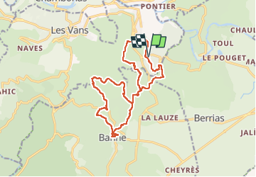
![](/images/other/stat-length.png)
![Randonnée Marche Les Vans - 07 bois Paiolive 12/05/22 - Photo](https://media.geolcdn.com/t/1900/400/10bc427e-4acd-45be-b5b6-80e9b6b8685a.jpg&format=pjpeg&maxdim=2)
07 bois Paiolive 12/05/22
silvestreclaudine
Utilisateur
![Longueur](/images/other/stat-length.png)
![Altitude max](https://static1.geolcdn.com/siteimages/upload/files/1508320355ic_sort_altitude_max_24dp.png)
![Dénivelé positif](https://static1.geolcdn.com/siteimages/upload/files/1508320355ic_sort_den_pos_24dp.png)
![Km-Effort](/images/other/stat-length.png)
![Altitude min](https://static1.geolcdn.com/siteimages/upload/files/1508320355ic_sort_altitude_min_24dp.png)
![Dénivelé négatif](https://static1.geolcdn.com/siteimages/upload/files/1508320355ic_sort_den_neg_24dp.png)
![Boucle](https://static1.geolcdn.com/siteimages/upload/files/16400158638029165_repeat_loop_refresh_sync_direction_icon.png)
![Marche](https://static1.geolcdn.com/sitytour/trail-icons/101.png)
6h50
Difficulté : Très difficile
![Scannez ce code QR pour ouvrir la randonnée dans l'application SityTrail](https://capi.geolives.com/qq0zvz2zws4bq2lad0pu/sitytour/trails/3240100/qr.png?size=200)
Application GPS de randonnée GRATUITE
À propos
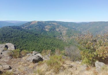
Randonnée Marche de 18 km à découvrir à Auvergne-Rhône-Alpes, Ardèche, Les Vans. Cette randonnée est proposée par silvestreclaudine.
Description
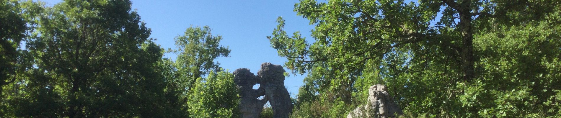
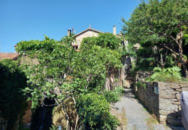
Départ de parking de l'ours et du lion
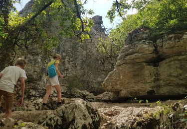
éviter un lendemain de grosse pluie, dalles calcaire glissantes!
traverser la route en direction du restaurant suivre le PR (jaune)
Prendre à gauche après la deuxième balise.
traverser la route et partir en face sur le GR4 , prendre à gauche dés la première intersection et suivre la route qui se termine par un sentier.repartir à gauche, le sentier descend . a l'intersection prendre à droite vers la grotte, arrivé dans le champ d'oliviers le contourner par la droite et au fond il y a le sentier. suivre les marques bleu (très discrètes!) après les ruines de voitures partir à droite vers le Mas de Granzon suivre le balisage.Descendre vers le Granzon ; remonter ensuite par le GR des Vans.
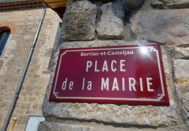
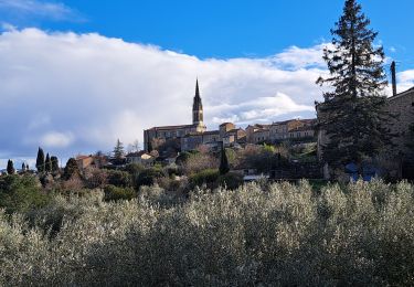
suivre la route, au croisement partir à droite sur la route et ensuite remonter sur le Gr à gauche. Au prochain carrefour partir à gauche (cairn)le sentier slalom dans la forêt et descend vers la route. traverser et descendre vers le pont pour remonter vers Banne.visite du village.redescendre par le même chemin mais rester sur la route. Un sentier descend à gauche.direction le Mas de Granzon, jardin écologique puis traverser le granzon pour remonter vers la distillerie du mas de granzon. retrouver le chemin jusqu'au point 210, en continuant tout droit , traversez la route D 901.
le sentier remonte dans le bois, prendre à gauche puis à droite au point 217, laisser le sentier qui part vers Berrias. Peu après on arrive à un
carrefour et ensuite un petit sentier part à droite très discret( parfois très épineux, prévoir un sécateur!!!)mais le sentier est très sauvage.vous sortez du chemin pour continuer sur un sentier fréquenté suivre l'indication " parking" puis sentier de la "vierge"prendre la direction du bestiaire mais prendre la deuxième sortie à droite. Au prochain croisement prendre à droite et le sentier arrive directement au parking.
Localisation
Commentaires
Randonnées à proximité
![Randonnée Marche Berrias-et-Casteljau - ARDÈCHE. BERRIAS. GORGES DE CHASSEZAC O - Photo](https://media.geolcdn.com/t/375/260/57afbf73-5c77-4144-bf42-14d64b3b569f.jpg&format=jpg&maxdim=2)
![Marche Marche](https://static1.geolcdn.com/sitytour/trail-icons/101.png)
Marche
![](/images/other/stat-length.png)
![](https://static1.geolcdn.com/siteimages/upload/files/16400158638029165_repeat_loop_refresh_sync_direction_icon.png)
![Randonnée Marche Banne - Autour de Banne - Photo](https://media.geolcdn.com/t/375/260/0d756104-e1b5-4f2e-b3d0-c252da0f965f.jpg&format=jpg&maxdim=2)
![Marche Marche](https://static1.geolcdn.com/sitytour/trail-icons/101.png)
Marche
![](/images/other/stat-length.png)
![](https://static1.geolcdn.com/siteimages/upload/files/16400158638029165_repeat_loop_refresh_sync_direction_icon.png)
![Randonnée Marche Les Vans - Vallée de la Gagnière - Photo](https://media.geolcdn.com/t/375/260/71917047-d88c-4c64-a341-02552bb982e0.jpg&format=jpg&maxdim=2)
![Marche Marche](https://static1.geolcdn.com/sitytour/trail-icons/101.png)
Marche
![](/images/other/stat-length.png)
![](https://static1.geolcdn.com/siteimages/upload/files/16400158638029165_repeat_loop_refresh_sync_direction_icon.png)
![Randonnée Marche Les Vans - Vallée de la Gagniére - Photo](https://media.geolcdn.com/t/375/260/1508dc5f-9f29-4533-9f11-f708e0c455a3.jpg&format=jpg&maxdim=2)
![Marche Marche](https://static1.geolcdn.com/sitytour/trail-icons/101.png)
Marche
![](/images/other/stat-length.png)
![](https://static1.geolcdn.com/siteimages/upload/files/16400158638029165_repeat_loop_refresh_sync_direction_icon.png)
![Randonnée Marche Les Vans - GRP Le Cévenol Brahic-Génolhac 32km - Photo](https://media.geolcdn.com/t/375/260/d74c8751-f379-4bc1-a2c8-84f5f2d71730.jpg&format=jpg&maxdim=2)
![Marche Marche](https://static1.geolcdn.com/sitytour/trail-icons/101.png)
Marche
![](/images/other/stat-length.png)
![](https://static1.geolcdn.com/siteimages/upload/files/16400158638029165_repeat_loop_refresh_sync_direction_icon.png)
![Randonnée Marche Berrias-et-Casteljau - Wikiloc Bois de Paiolive (PVDB) - Photo](https://media.geolcdn.com/t/375/260/045714af-a6fd-44e6-8871-35194bcde521.jpg&format=jpg&maxdim=2)
![Marche Marche](https://static1.geolcdn.com/sitytour/trail-icons/101.png)
Marche
![](/images/other/stat-length.png)
![](https://static1.geolcdn.com/siteimages/upload/files/16400158638029165_repeat_loop_refresh_sync_direction_icon.png)
![Randonnée Marche Les Vans - Bois de Païolive - Photo](https://media.geolcdn.com/t/375/260/ext.jpg?maxdim=2&url=https%3A%2F%2Fservices.sitytrail.com%2FGeolivesWS%2FDownloadMedia.ashx%3FTrailID%3D372613%26Media%3Dfix__20141226114045.jpg)
![Marche Marche](https://static1.geolcdn.com/sitytour/trail-icons/101.png)
Marche
![](/images/other/stat-length.png)
![](https://static1.geolcdn.com/siteimages/upload/files/16400158638029165_repeat_loop_refresh_sync_direction_icon.png)
![Randonnée Marche Berrias-et-Casteljau - paiolive - Photo](https://media.geolcdn.com/t/375/260/ext.jpg?maxdim=2&url=https%3A%2F%2Fstatic1.geolcdn.com%2Fsiteimages%2Fupload%2Ffiles%2F1553511878bg_sport_marche.png)
![Marche Marche](https://static1.geolcdn.com/sitytour/trail-icons/101.png)
Marche
![](/images/other/stat-length.png)
![](https://static1.geolcdn.com/siteimages/upload/files/16400158638029165_repeat_loop_refresh_sync_direction_icon.png)
![Randonnée V.T.T. Berrias-et-Casteljau - Berias et environ - Photo](https://media.geolcdn.com/t/375/260/ext.jpg?maxdim=2&url=https%3A%2F%2Fstatic1.geolcdn.com%2Fsiteimages%2Fupload%2Ffiles%2F1524743154velo.jpg)
![V.T.T. V.T.T.](https://static1.geolcdn.com/sitytour/trail-icons/202.png)
V.T.T.
![](/images/other/stat-length.png)
![](https://static1.geolcdn.com/siteimages/upload/files/16400158638029165_repeat_loop_refresh_sync_direction_icon.png)