![](/images/other/stat-length.png)
![Randonnée Marche Saint-Mard - Le tour du grand Paris via le GR1 Etape 9 Dammartin en Goele - Meaux - Photo](https://media.geolcdn.com/t/1900/400/c2b9ac23-3f31-4bcb-a8f1-c9edbe9e7c1b.jpg&format=pjpeg&maxdim=2)
Le tour du grand Paris via le GR1 Etape 9 Dammartin en Goele - Meaux
chessyca
Utilisateur GUIDE
![Longueur](/images/other/stat-length.png)
Longueur
22 km
![Altitude max](https://static1.geolcdn.com/siteimages/upload/files/1508320355ic_sort_altitude_max_24dp.png)
Altitude max
203 m
![Dénivelé positif](https://static1.geolcdn.com/siteimages/upload/files/1508320355ic_sort_den_pos_24dp.png)
Dénivelé positif
312 m
![Km-Effort](/images/other/stat-length.png)
Km-Effort
26 km
![Altitude min](https://static1.geolcdn.com/siteimages/upload/files/1508320355ic_sort_altitude_min_24dp.png)
Altitude min
46 m
![Dénivelé négatif](https://static1.geolcdn.com/siteimages/upload/files/1508320355ic_sort_den_neg_24dp.png)
Dénivelé négatif
367 m
![Boucle](https://static1.geolcdn.com/siteimages/upload/files/16400158638029165_repeat_loop_refresh_sync_direction_icon.png)
Boucle
Non
Date de création :
2022-05-12 06:41:43.061
Dernière modification :
2022-05-12 19:20:55.805
![Marche](https://static1.geolcdn.com/sitytour/trail-icons/101.png)
5h43
Difficulté : Moyen
![Scannez ce code QR pour ouvrir la randonnée dans l'application SityTrail](https://capi.geolives.com/qq0zvz2zws4bq2lad0pu/sitytour/trails/3239331/qr.png?size=200)
Application GPS de randonnée GRATUITE
À propos
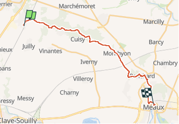
Randonnée Marche de 22 km à découvrir à Île-de-France, Seine-et-Marne, Saint-Mard. Cette randonnée est proposée par chessyca.
Description
Etape courte effectuée dans la matinée sur une allure plus rapide.
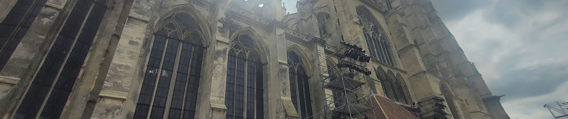
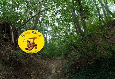
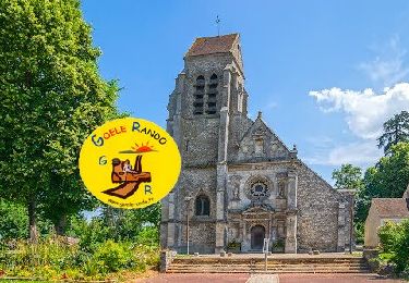
A l'exception de la cathédrale de Meaux , vraiment rien de passionnnant sur le parcours.
Localisation
Pays :
France
Région :
Île-de-France
Département/Province :
Seine-et-Marne
Commune :
Saint-Mard
Localité :
Unknown
Départ:(Dec)
Départ:(UTM)
477975 ; 5431052 (31U) N.
Commentaires
Randonnées à proximité
![Randonnée Marche Vinantes - SM_VINANTES_7.9Km - Photo](https://media.geolcdn.com/t/375/260/13298252-6192-4688-8560-e862227f2560.jpg&format=jpg&maxdim=2)
![Marche Marche](https://static1.geolcdn.com/sitytour/trail-icons/101.png)
SM_VINANTES_7.9Km
Marche
Moyen
(5)
Vinantes,
Île-de-France,
Seine-et-Marne,
France
![](/images/other/stat-length.png)
7,9 km | 8,9 km-effort
2h 1min
![](https://static1.geolcdn.com/siteimages/upload/files/16400158638029165_repeat_loop_refresh_sync_direction_icon.png)
Oui
![Randonnée Marche Montgé-en-Goële - MR_MONTGE-en-GOELE_5.3Km - Photo](https://media.geolcdn.com/t/375/260/35addc96-117d-441b-96c3-8a9f60ce0ef4.jpg&format=jpg&maxdim=2)
![Marche Marche](https://static1.geolcdn.com/sitytour/trail-icons/101.png)
MR_MONTGE-en-GOELE_5.3Km
Marche
Moyen
(5)
Montgé-en-Goële,
Île-de-France,
Seine-et-Marne,
France
![](/images/other/stat-length.png)
5,3 km | 6,8 km-effort
1h 32min
![](https://static1.geolcdn.com/siteimages/upload/files/16400158638029165_repeat_loop_refresh_sync_direction_icon.png)
Oui
![Randonnée A pied Saint-Mard - Formation SITY TRAIL_SAINT MARD - Photo](https://media.geolcdn.com/t/375/260/ba3d62a0-8f58-458e-9ed8-b3b717ccdf4f.jpg&format=jpg&maxdim=2)
![A pied A pied](https://static1.geolcdn.com/sitytour/trail-icons/100.png)
Formation SITY TRAIL_SAINT MARD
A pied
Très facile
(3)
Saint-Mard,
Île-de-France,
Seine-et-Marne,
France
![](/images/other/stat-length.png)
3,6 km | 4,4 km-effort
Inconnu
![](https://static1.geolcdn.com/siteimages/upload/files/16400158638029165_repeat_loop_refresh_sync_direction_icon.png)
Oui
![Randonnée Marche Montgé-en-Goële - SM_Montgé en Goële_8Km - Photo](https://media.geolcdn.com/t/375/260/512ace96-07d5-42e9-972d-de3ead1e1b12.jpg&format=jpg&maxdim=2)
![Marche Marche](https://static1.geolcdn.com/sitytour/trail-icons/101.png)
SM_Montgé en Goële_8Km
Marche
Moyen
(3)
Montgé-en-Goële,
Île-de-France,
Seine-et-Marne,
France
![](/images/other/stat-length.png)
8 km | 9,7 km-effort
2h 12min
![](https://static1.geolcdn.com/siteimages/upload/files/16400158638029165_repeat_loop_refresh_sync_direction_icon.png)
Oui
![Randonnée Marche Vinantes - SM_VINANTES (par Montgé)_8.2Km - Photo](https://media.geolcdn.com/t/375/260/13298252-6192-4688-8560-e862227f2560.jpg&format=jpg&maxdim=2)
![Marche Marche](https://static1.geolcdn.com/sitytour/trail-icons/101.png)
SM_VINANTES (par Montgé)_8.2Km
Marche
Moyen
(1)
Vinantes,
Île-de-France,
Seine-et-Marne,
France
![](/images/other/stat-length.png)
8,1 km | 9,6 km-effort
2h 10min
![](https://static1.geolcdn.com/siteimages/upload/files/16400158638029165_repeat_loop_refresh_sync_direction_icon.png)
Oui
![Randonnée Marche Othis - SM_OTHIS-(PR Gérard de NERVAL)-Parc Beaupre_8.4Km - Photo](https://media.geolcdn.com/t/375/260/14c3ca26-f317-4a5a-aaff-75fa15b629d2.jpg&format=jpg&maxdim=2)
![Marche Marche](https://static1.geolcdn.com/sitytour/trail-icons/101.png)
SM_OTHIS-(PR Gérard de NERVAL)-Parc Beaupre_8.4Km
Marche
Moyen
(1)
Othis,
Île-de-France,
Seine-et-Marne,
France
![](/images/other/stat-length.png)
8,4 km | 9,1 km-effort
2h 4min
![](https://static1.geolcdn.com/siteimages/upload/files/16400158638029165_repeat_loop_refresh_sync_direction_icon.png)
Oui
![Randonnée Marche Montgé-en-Goële - Montgé en Goële SuperMiniRando - Photo](https://media.geolcdn.com/t/375/260/ext.jpg?maxdim=2&url=https%3A%2F%2Fstatic1.geolcdn.com%2Fsiteimages%2Fupload%2Ffiles%2F1553511878bg_sport_marche.png)
![Marche Marche](https://static1.geolcdn.com/sitytour/trail-icons/101.png)
Montgé en Goële SuperMiniRando
Marche
Facile
(1)
Montgé-en-Goële,
Île-de-France,
Seine-et-Marne,
France
![](/images/other/stat-length.png)
8 km | 9,6 km-effort
1h 59min
![](https://static1.geolcdn.com/siteimages/upload/files/16400158638029165_repeat_loop_refresh_sync_direction_icon.png)
Oui
![Randonnée Marche Dammartin-en-Goële - Dammartin en Goële RC 2016 Grand parcours - Photo](https://media.geolcdn.com/t/375/260/ext.jpg?maxdim=2&url=https%3A%2F%2Fstatic1.geolcdn.com%2Fsiteimages%2Fupload%2Ffiles%2F1553511878bg_sport_marche.png)
![Marche Marche](https://static1.geolcdn.com/sitytour/trail-icons/101.png)
Dammartin en Goële RC 2016 Grand parcours
Marche
Facile
(2)
Dammartin-en-Goële,
Île-de-France,
Seine-et-Marne,
France
![](/images/other/stat-length.png)
19,3 km | 22 km-effort
4h 51min
![](https://static1.geolcdn.com/siteimages/upload/files/16400158638029165_repeat_loop_refresh_sync_direction_icon.png)
Oui
![Randonnée Marche Vinantes - MR_VINANTES-NORD_5.4Km - Photo](https://media.geolcdn.com/t/375/260/f80d919d-5959-4660-8833-ae937cc22606.jpg&format=jpg&maxdim=2)
![Marche Marche](https://static1.geolcdn.com/sitytour/trail-icons/101.png)
MR_VINANTES-NORD_5.4Km
Marche
Moyen
Vinantes,
Île-de-France,
Seine-et-Marne,
France
![](/images/other/stat-length.png)
5,4 km | 6,1 km-effort
1h 23min
![](https://static1.geolcdn.com/siteimages/upload/files/16400158638029165_repeat_loop_refresh_sync_direction_icon.png)
Oui