Randonnée Marche Saint-Jean-de-la-Blaquière - Dyke&Neck - Photo
 bsddbs
bsddbs

Utilisateur

© OpenStreetMap contributors
Longueur
Longueur
124 km
Boucle
Boucle
Non
Date de création :
2022-05-10 09:01:15.673
Dernière modification :
2022-05-10 16:57:34.38

(0 Avis)

Marche
Marche
7h55
Difficulté : Très difficile

Scannez ce code QR pour ouvrir la randonnée dans l'application SityTrail

Application GPS de randonnée GRATUITE

Logo SityTrail SityTrail

IGN / Instituts géographiques

Télécharger SityTrail sur l'App Store Télécharger SityTrail sur Google Play

Logo SityTrail SityTrail World

Le monde est à vous

Télécharger SityTrail sur l'App Store Télécharger SityTrail sur Google Play Télécharger SityTrail sur Huawei AppGallery

À propos

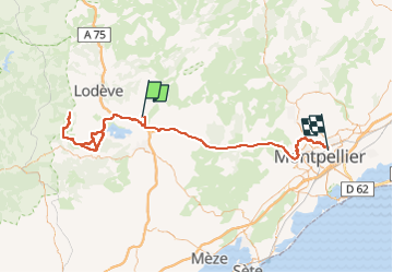
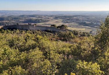
Randonnée Marche de 124 km à découvrir à Occitanie, Hérault, Saint-Jean-de-la-Blaquière. Cette randonnée est proposée par bsddbs.

Profil altimétrique

Localisation

Pays :
France
Région :
Occitanie
Département/Province :
Hérault
Commune :
Saint-Jean-de-la-Blaquière
Localité :
Unknown
Départ:(UTM)
534707 ; 4836742 (31T) N.

Randonnées à proximité

Randonnée Marche Le Bosc - Saint-Alban - Célis - La Roque  - Photo
Marche
mdauzat

Marche

Moyen
(1)
Le Bosc, Occitanie, Hérault, France
5,7 km | 7,9 km-effort
1h 47min
Oui
Randonnée Marche Saint-Saturnin-de-Lucian - Le Rocher des vierges - Photo
Marche
daniel34

Marche

Moyen
(2)
Saint-Saturnin-de-Lucian, Occitanie, Hérault, France
12,1 km | 17,4 km-effort
5h 1min
Oui
Randonnée Marche Le Bosc - Le Bosc - prieuré de Grandmont - Le Brédou - Soumont - Photo
Marche
vertygo

Marche

Moyen
(2)
Le Bosc, Occitanie, Hérault, France
19,1 km | 28 km-effort
5h 46min
Oui
Randonnée Marche Lacoste - lacoste vers le lac - Photo
Marche
kiki34

Marche

Moyen
(2)
Lacoste, Occitanie, Hérault, France
12,2 km | 15,4 km-effort
3h 11min
Oui
Randonnée V.T.T. Clermont-l'Hérault - Espace VTT FFC Salagou - Circuit n° 2 - Les Balcons du Salagou - Photo
V.T.T.
tracegps

V.T.T.

Moyen
(1)
Clermont-l'Hérault, Occitanie, Hérault, France
12,3 km | 15,6 km-effort
1h 10min
Oui
Randonnée V.T.T. Clermont-l'Hérault - Espace VTT FFC Salagou - Circuit n° 1 - Le Lac du Salagou - Photo
V.T.T.
tracegps

V.T.T.

Difficile
(4)
Clermont-l'Hérault, Occitanie, Hérault, France
27 km | 32 km-effort
2h 0min
Oui
Randonnée Marche Saint-Jean-de-la-Blaquière - Les Bois de Homs et de Latude - Photo
Marche
gerardhenr

Marche

Facile
(1)
Saint-Jean-de-la-Blaquière, Occitanie, Hérault, France
9,3 km | 13,1 km-effort
2h 27min
Oui
Randonnée Marche Clermont-l'Hérault - les vailhes - Photo
Marche
dpop34

Marche

Très facile
(1)
Clermont-l'Hérault, Occitanie, Hérault, France
15,2 km | 20 km-effort
3h 17min
Oui
Randonnée Marche Montpeyroux - Le Castellas de Montpeyroux - Photo
Marche
Indi34

Marche

Moyen
Montpeyroux, Occitanie, Hérault, France
6,6 km | 9,5 km-effort
2h 2min
Oui


Fermer
Mes abonnements