![](/images/other/stat-length.png)
![Randonnée Marche Mons - SPIENNES _ Marche Adeps _ HT_ 8/05/2022 - Photo](https://media.geolcdn.com/t/1900/400/775b08c4-3ca1-4fce-9d4d-9db1eedc3cc4.jpg&format=pjpeg&maxdim=2)
SPIENNES _ Marche Adeps _ HT_ 8/05/2022
jeangulu
Utilisateur
![Longueur](/images/other/stat-length.png)
Longueur
18,2 km
![Altitude max](https://static1.geolcdn.com/siteimages/upload/files/1508320355ic_sort_altitude_max_24dp.png)
Altitude max
113 m
![Dénivelé positif](https://static1.geolcdn.com/siteimages/upload/files/1508320355ic_sort_den_pos_24dp.png)
Dénivelé positif
191 m
![Km-Effort](/images/other/stat-length.png)
Km-Effort
21 km
![Altitude min](https://static1.geolcdn.com/siteimages/upload/files/1508320355ic_sort_altitude_min_24dp.png)
Altitude min
36 m
![Dénivelé négatif](https://static1.geolcdn.com/siteimages/upload/files/1508320355ic_sort_den_neg_24dp.png)
Dénivelé négatif
191 m
![Boucle](https://static1.geolcdn.com/siteimages/upload/files/16400158638029165_repeat_loop_refresh_sync_direction_icon.png)
Boucle
Oui
Date de création :
2022-05-08 09:38:32.692
Dernière modification :
2022-05-08 14:14:22.923
![Marche](https://static1.geolcdn.com/sitytour/trail-icons/101.png)
4h32
Difficulté : Facile
![Scannez ce code QR pour ouvrir la randonnée dans l'application SityTrail](https://capi.geolives.com/qq0zvz2zws4bq2lad0pu/sitytour/trails/3234457/qr.png?size=200)
Application GPS de randonnée GRATUITE
À propos
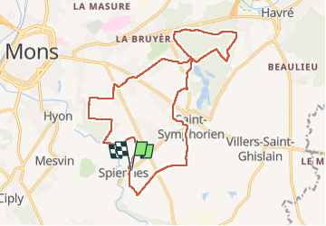
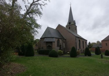
Randonnée Marche de 18,2 km à découvrir à Wallonie, Hainaut, Mons. Cette randonnée est proposée par jeangulu.
Description
Point de départ : Rue Gontrand Bachy (7032).
Entité : MONS.
Organisateur : Comité des fêtes de Spiennes _ Olivier Maîtresse.
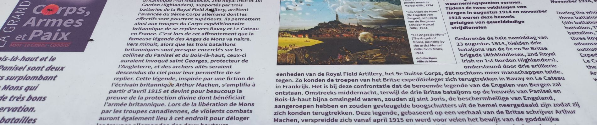
Très belle marche.
Localisation
Pays :
Belgique
Région :
Wallonie
Département/Province :
Hainaut
Commune :
Mons
Localité :
Unknown
Départ:(Dec)
Départ:(UTM)
570330 ; 5586470 (31U) N.
Commentaires
Randonnées à proximité
![Randonnée Marche Mons - RB-Ha-13 - Spiennes - Photo](https://media.geolcdn.com/t/375/260/ext.jpg?maxdim=2&url=https%3A%2F%2Fservices.sitytrail.com%2FGeolivesWS%2FDownloadMedia.ashx%3FTrailID%3D179607%26Media%3Dee6cd659-80c2-435e-9976-43cb94344f6e.jpg)
![Marche Marche](https://static1.geolcdn.com/sitytour/trail-icons/101.png)
RB-Ha-13 - Spiennes
Marche
Très difficile
(5)
Mons,
Wallonie,
Hainaut,
Belgique
![](/images/other/stat-length.png)
21 km | 25 km-effort
5h 40min
![](https://static1.geolcdn.com/siteimages/upload/files/16400158638029165_repeat_loop_refresh_sync_direction_icon.png)
Oui
![Randonnée Marche Mons - Nuit du scoutisme - Mons - Photo](https://media.geolcdn.com/t/375/260/87b716aa-c8cf-4b43-af3b-2f8493539c6a.jpg&format=jpg&maxdim=2)
![Marche Marche](https://static1.geolcdn.com/sitytour/trail-icons/101.png)
Nuit du scoutisme - Mons
Marche
Facile
(10)
Mons,
Wallonie,
Hainaut,
Belgique
![](/images/other/stat-length.png)
4,4 km | 5,2 km-effort
1h 10min
![](https://static1.geolcdn.com/siteimages/upload/files/16400158638029165_repeat_loop_refresh_sync_direction_icon.png)
Oui
![Randonnée Marche Mons - RB-Ha-13 - Spiennes - Via raccourci - Photo](https://media.geolcdn.com/t/375/260/ext.jpg?maxdim=2&url=https%3A%2F%2Fservices.sitytrail.com%2FGeolivesWS%2FDownloadMedia.ashx%3FTrailID%3D219513%26Media%3Dee6cd659-80c2-435e-9976-43cb94344f6e.jpg)
![Marche Marche](https://static1.geolcdn.com/sitytour/trail-icons/101.png)
RB-Ha-13 - Spiennes - Via raccourci
Marche
Très difficile
(3)
Mons,
Wallonie,
Hainaut,
Belgique
![](/images/other/stat-length.png)
16,2 km | 20 km-effort
4h 32min
![](https://static1.geolcdn.com/siteimages/upload/files/16400158638029165_repeat_loop_refresh_sync_direction_icon.png)
Oui
![Randonnée Marche Mons - RB-Ha-13 - Spiennes - Via allongement - Photo](https://media.geolcdn.com/t/375/260/ext.jpg?maxdim=2&url=https%3A%2F%2Fstatic1.geolcdn.com%2Fsiteimages%2Fupload%2Ffiles%2F1553511878bg_sport_marche.png)
![Marche Marche](https://static1.geolcdn.com/sitytour/trail-icons/101.png)
RB-Ha-13 - Spiennes - Via allongement
Marche
Très difficile
(1)
Mons,
Wallonie,
Hainaut,
Belgique
![](/images/other/stat-length.png)
24 km | 29 km-effort
6h 28min
![](https://static1.geolcdn.com/siteimages/upload/files/16400158638029165_repeat_loop_refresh_sync_direction_icon.png)
Oui
![Randonnée Marche Mons - Balade dans le bois d'Havré - Photo](https://media.geolcdn.com/t/375/260/ext.jpg?maxdim=2&url=https%3A%2F%2Fservices.sitytrail.com%2FGeolivesWS%2FDownloadMedia.ashx%3FTrailID%3D100535%26Media%3D87419146-43c8-4ee2-bd27-497925302c85.JPG)
![Marche Marche](https://static1.geolcdn.com/sitytour/trail-icons/101.png)
Balade dans le bois d'Havré
Marche
Très facile
(1)
Mons,
Wallonie,
Hainaut,
Belgique
![](/images/other/stat-length.png)
9,1 km | 10,3 km-effort
2h 10min
![](https://static1.geolcdn.com/siteimages/upload/files/16400158638029165_repeat_loop_refresh_sync_direction_icon.png)
Oui
![Randonnée Marche Mons - petit tour à mons - Photo](https://media.geolcdn.com/t/375/260/d7cbcfa9-b19e-435e-ba25-f17ef2758d9e.jpg&format=jpg&maxdim=2)
![Marche Marche](https://static1.geolcdn.com/sitytour/trail-icons/101.png)
petit tour à mons
Marche
Très facile
Mons,
Wallonie,
Hainaut,
Belgique
![](/images/other/stat-length.png)
4,5 km | 5,3 km-effort
1h 38min
![](https://static1.geolcdn.com/siteimages/upload/files/16400158638029165_repeat_loop_refresh_sync_direction_icon.png)
Oui
![Marche Marche](https://static1.geolcdn.com/sitytour/trail-icons/101.png)
Marche Adeps à Saint-Symphorien
Marche
Très facile
Mons,
Wallonie,
Hainaut,
Belgique
![](/images/other/stat-length.png)
11,2 km | 13 km-effort
4h 27min
![](https://static1.geolcdn.com/siteimages/upload/files/16400158638029165_repeat_loop_refresh_sync_direction_icon.png)
Oui
![Randonnée Marche Mons - marche 5-06 montpanisel - Photo](https://media.geolcdn.com/t/375/260/ext.jpg?maxdim=2&url=https%3A%2F%2Fstatic1.geolcdn.com%2Fsiteimages%2Fupload%2Ffiles%2F1553511878bg_sport_marche.png)
![Marche Marche](https://static1.geolcdn.com/sitytour/trail-icons/101.png)
marche 5-06 montpanisel
Marche
Très facile
(1)
Mons,
Wallonie,
Hainaut,
Belgique
![](/images/other/stat-length.png)
7,1 km | 8,9 km-effort
1h 38min
![](https://static1.geolcdn.com/siteimages/upload/files/16400158638029165_repeat_loop_refresh_sync_direction_icon.png)
Oui
![Randonnée V.T.T. Mons - transboraine 34km - Photo](https://media.geolcdn.com/t/375/260/ext.jpg?maxdim=2&url=https%3A%2F%2Fstatic1.geolcdn.com%2Fsiteimages%2Fupload%2Ffiles%2F1524743154velo.jpg)
![V.T.T. V.T.T.](https://static1.geolcdn.com/sitytour/trail-icons/202.png)
transboraine 34km
V.T.T.
Moyen
(1)
Mons,
Wallonie,
Hainaut,
Belgique
![](/images/other/stat-length.png)
33 km | 39 km-effort
Inconnu
![](https://static1.geolcdn.com/siteimages/upload/files/16400158638029165_repeat_loop_refresh_sync_direction_icon.png)
Non