Randonnée  Saint-Hubert - 2022-05-08_15h03m21_Cirkwi-Rando_et_Bivouac_autour_de_Saint-Hubert - Photo

2022-05-08_15h03m21_Cirkwi-Rando_et_Bivouac_autour_de_Saint-Hubert

 le koyote
le koyote

Utilisateur

© OpenStreetMap contributors
Longueur
Longueur
56 km
Altitude max
Altitude max
594 m
Dénivelé positif
Dénivelé positif
1271 m
Km-Effort
Km-Effort  
73 km
Altitude min
Altitude min
288 m
Dénivelé négatif
Dénivelé négatif
1275 m
Boucle
Boucle
Oui
Date de création :
2022-05-08 13:03:21.306
Dernière modification :
2022-05-08 13:03:22.502

(0 Avis)


Scannez ce code QR pour ouvrir la randonnée dans l'application SityTrail

Application GPS de randonnée GRATUITE

Logo SityTrail SityTrail

IGN / Instituts géographiques

Télécharger SityTrail sur l'App Store Télécharger SityTrail sur Google Play

Logo SityTrail SityTrail World

Le monde est à vous

Télécharger SityTrail sur l'App Store Télécharger SityTrail sur Google Play Télécharger SityTrail sur Huawei AppGallery

À propos

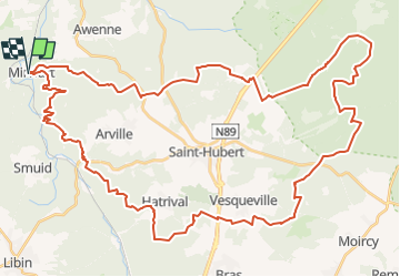
Randonnée de 56 km à découvrir à Wallonie, Luxembourg, Saint-Hubert. Cette randonnée est proposée par le koyote.

Description

Envie de passer 48heures en pleine nature ? De profiter d’une soirée au coin du feu ? De découvrir des paysages étonnants ? Je vous propose une rando et bivouac autour de Saint-Hubert pour découvrir l’une des plus belles forêts d’Ardenne. Récit, itinéraire et conseils, je vous dit tout pour revivre cette microaventure dans la Grande Forêt de Saint-Hubert. Plus d'infos : https://www.sentiersduphoenix.be/rando-et-bivouac-autour-de-saint-hubert/

Profil altimétrique

Localisation

Pays :
Belgique
Région :
Wallonie
Département/Province :
Luxembourg
Commune :
Saint-Hubert
Localité :
Unknown
Départ:(UTM)
662045 ; 5547341 (31U) N.

Randonnées à proximité

Randonnée Marche Tellin - Tellin. Natura 2000, des sites qui valent le détour ! Lx 7 - Photo
Marche
GUIDE+

Marche

Moyen
(6)
Tellin, Wallonie, Luxembourg, Belgique
9,6 km | 11,9 km-effort
1h 30min
Oui
Randonnée Marche Saint-Hubert - Poix - Sainte-Adeline (SH15) - Photo
Marche
GUIDE+

Marche

Moyen
(7)
Saint-Hubert, Wallonie, Luxembourg, Belgique
8,3 km | 10,8 km-effort
2h 23min
Oui
Randonnée Marche Saint-Hubert - Mirwart_Vieux Moulin de Mirwart_Alternative Forêt (SH29 bis) - Photo
Marche
GUIDE+

Marche

Difficile
(12)
Saint-Hubert, Wallonie, Luxembourg, Belgique
10,8 km | 14,2 km-effort
3h 4min
Oui
Randonnée Marche Saint-Hubert - Marche ADEPS Arville - Photo
Marche
GUIDE
Bernard Gillet

Marche

Moyen
(1)
Saint-Hubert, Wallonie, Luxembourg, Belgique
10,2 km | 13,6 km-effort
2h 13min
Oui
Randonnée Marche Tellin - RL-GG-13_Grupont_Poix-Saint-Hubert - Photo
Marche
PRO

Marche

Très difficile
(2)
Tellin, Wallonie, Luxembourg, Belgique
26 km | 34 km-effort
7h 23min
Non
Randonnée Marche Tellin - Balade à Grupont - Photo
Marche
GUIDE
Desrumaux

Marche

Facile
(1)
Tellin, Wallonie, Luxembourg, Belgique
8,4 km | 11,9 km-effort
2h 33min
Oui
Randonnée Marche Tellin - Bure - Promenade des chapelles - Photo
Marche
GUIDE+

Marche

Facile
(1)
Tellin, Wallonie, Luxembourg, Belgique
4,5 km | 5,9 km-effort
1h 15min
Oui
Randonnée Marche Tellin - Tellin - Promenade du trou des Lûtons - Photo
Marche
GUIDE+

Marche

Facile
(1)
Tellin, Wallonie, Luxembourg, Belgique
5,2 km | 6,1 km-effort
1h 21min
Oui
Randonnée A pied Tellin - Tellin - Promenade des étangs - Photo
A pied
GUIDE+

A pied

Moyen
(2)
Tellin, Wallonie, Luxembourg, Belgique
20 km | 27 km-effort
Inconnu
Oui


Fermer
Mes abonnements