![](/images/other/stat-length.png)
![Randonnée Marche Laval-en-Belledonne - Tour du vallon de Laval - Photo](https://media.geolcdn.com/t/1900/400/a31847b6-2af2-41ec-ac8f-7d673e513f01.jpg&format=pjpeg&maxdim=2)
Tour du vallon de Laval
Emelle
Utilisateur
![Longueur](/images/other/stat-length.png)
Longueur
13,5 km
![Altitude max](https://static1.geolcdn.com/siteimages/upload/files/1508320355ic_sort_altitude_max_24dp.png)
Altitude max
1065 m
![Dénivelé positif](https://static1.geolcdn.com/siteimages/upload/files/1508320355ic_sort_den_pos_24dp.png)
Dénivelé positif
546 m
![Km-Effort](/images/other/stat-length.png)
Km-Effort
21 km
![Altitude min](https://static1.geolcdn.com/siteimages/upload/files/1508320355ic_sort_altitude_min_24dp.png)
Altitude min
596 m
![Dénivelé négatif](https://static1.geolcdn.com/siteimages/upload/files/1508320355ic_sort_den_neg_24dp.png)
Dénivelé négatif
569 m
![Boucle](https://static1.geolcdn.com/siteimages/upload/files/16400158638029165_repeat_loop_refresh_sync_direction_icon.png)
Boucle
Oui
Date de création :
2022-05-08 07:33:22.468
Dernière modification :
2022-05-11 19:50:25.113
![Marche](https://static1.geolcdn.com/sitytour/trail-icons/101.png)
4h38
Difficulté : Moyen
![Scannez ce code QR pour ouvrir la randonnée dans l'application SityTrail](https://capi.geolives.com/qq0zvz2zws4bq2lad0pu/sitytour/trails/3234296/qr.png?size=200)
Application GPS de randonnée GRATUITE
À propos
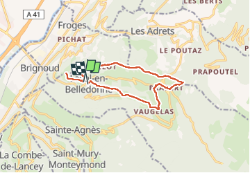
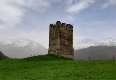
Randonnée Marche de 13,5 km à découvrir à Auvergne-Rhône-Alpes, Isère, Laval-en-Belledonne. Cette randonnée est proposée par Emelle.
Description
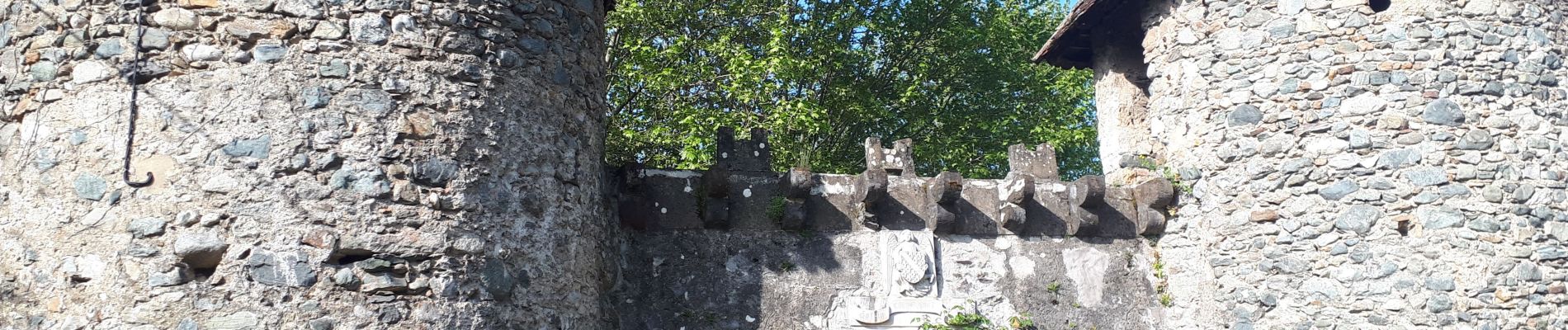
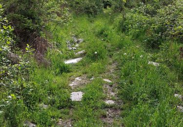
Belle randonnée campagnarde, bucolique et riche en patrimoine bien documenté sur le parcours. Hormis quelques montées un peu soutenue et une descente raide après Blérot, aucune difficulté.
Localisation
Pays :
France
Région :
Auvergne-Rhône-Alpes
Département/Province :
Isère
Commune :
Laval-en-Belledonne
Localité :
Unknown
Départ:(Dec)
Départ:(UTM)
729928 ; 5015258 (31T) N.
Commentaires
Randonnées à proximité
![Randonnée Marche Les Adrets - les 7 laux - Photo](https://media.geolcdn.com/t/375/260/ext.jpg?maxdim=2&url=https%3A%2F%2Fservices.sitytrail.com%2FGeolivesWS%2FDownloadMedia.ashx%3FTrailID%3D210621%26Media%3Dfix__20130806134428.jpg)
![Marche Marche](https://static1.geolcdn.com/sitytour/trail-icons/101.png)
les 7 laux
Marche
Moyen
(1)
Les Adrets,
Auvergne-Rhône-Alpes,
Isère,
France
![](/images/other/stat-length.png)
12,4 km | 21 km-effort
4h 23min
![](https://static1.geolcdn.com/siteimages/upload/files/16400158638029165_repeat_loop_refresh_sync_direction_icon.png)
Oui
![Randonnée A pied La Combe-de-Lancey - Chemin de Découverte (boucle Basse) - Photo](https://media.geolcdn.com/t/375/260/6915f95f-b034-4e84-88aa-9ed85af7f443.jpeg&format=jpg&maxdim=2)
![A pied A pied](https://static1.geolcdn.com/sitytour/trail-icons/100.png)
Chemin de Découverte (boucle Basse)
A pied
Facile
La Combe-de-Lancey,
Auvergne-Rhône-Alpes,
Isère,
France
![](/images/other/stat-length.png)
3,5 km | 5,1 km-effort
1h 9min
![](https://static1.geolcdn.com/siteimages/upload/files/16400158638029165_repeat_loop_refresh_sync_direction_icon.png)
Oui
![Randonnée A pied La Combe-de-Lancey - Chemin de Découverte (boucle Haute) - Photo](https://media.geolcdn.com/t/375/260/6a0cb0d1-93da-4068-99ad-9a549161cacf.jpeg&format=jpg&maxdim=2)
![A pied A pied](https://static1.geolcdn.com/sitytour/trail-icons/100.png)
Chemin de Découverte (boucle Haute)
A pied
Facile
La Combe-de-Lancey,
Auvergne-Rhône-Alpes,
Isère,
France
![](/images/other/stat-length.png)
3,5 km | 5,4 km-effort
1h 13min
![](https://static1.geolcdn.com/siteimages/upload/files/16400158638029165_repeat_loop_refresh_sync_direction_icon.png)
Oui
![Randonnée Ski de randonnée Laval-en-Belledonne - col du Rafour et couloir ouest de la montagne de Barlet - Photo](https://media.geolcdn.com/t/375/260/93573ad3-540b-4442-acb2-432d15b1a0ec.jpg&format=jpg&maxdim=2)
![Ski de randonnée Ski de randonnée](https://static1.geolcdn.com/sitytour/trail-icons/503.png)
col du Rafour et couloir ouest de la montagne de Barlet
Ski de randonnée
Difficile
Laval-en-Belledonne,
Auvergne-Rhône-Alpes,
Isère,
France
![](/images/other/stat-length.png)
10,9 km | 26 km-effort
6h 29min
![](https://static1.geolcdn.com/siteimages/upload/files/16400158638029165_repeat_loop_refresh_sync_direction_icon.png)
Non
![Randonnée Marche Theys - PROMENADE AUTOUR DU COL DES AYES - Photo](https://media.geolcdn.com/t/375/260/abb3a05c-1892-4f25-9e89-1857c335746d.jpg&format=jpg&maxdim=2)
![Marche Marche](https://static1.geolcdn.com/sitytour/trail-icons/101.png)
PROMENADE AUTOUR DU COL DES AYES
Marche
Moyen
Theys,
Auvergne-Rhône-Alpes,
Isère,
France
![](/images/other/stat-length.png)
5,1 km | 8,1 km-effort
3h 31min
![](https://static1.geolcdn.com/siteimages/upload/files/16400158638029165_repeat_loop_refresh_sync_direction_icon.png)
Oui
![Randonnée Marche Laval-en-Belledonne - PETITE RANDONNEE AU DEPART DU PONT DE LA BETTA - Photo](https://media.geolcdn.com/t/375/260/75136744-9eff-4307-a3ab-8becdc263614.jpg&format=jpg&maxdim=2)
![Marche Marche](https://static1.geolcdn.com/sitytour/trail-icons/101.png)
PETITE RANDONNEE AU DEPART DU PONT DE LA BETTA
Marche
Moyen
Laval-en-Belledonne,
Auvergne-Rhône-Alpes,
Isère,
France
![](/images/other/stat-length.png)
6,1 km | 9,9 km-effort
1h 35min
![](https://static1.geolcdn.com/siteimages/upload/files/16400158638029165_repeat_loop_refresh_sync_direction_icon.png)
Oui
![Randonnée Marche La Combe-de-Lancey - Col du Pré du Molard - Photo](https://media.geolcdn.com/t/375/260/29dc783a-080e-448f-b06b-b4c5ed8fc906.jpg&format=jpg&maxdim=2)
![Marche Marche](https://static1.geolcdn.com/sitytour/trail-icons/101.png)
Col du Pré du Molard
Marche
Difficile
La Combe-de-Lancey,
Auvergne-Rhône-Alpes,
Isère,
France
![](/images/other/stat-length.png)
17,8 km | 33 km-effort
5h 19min
![](https://static1.geolcdn.com/siteimages/upload/files/16400158638029165_repeat_loop_refresh_sync_direction_icon.png)
Oui
![Randonnée Marche Laval-en-Belledonne - Boucle Laval - Sainte-Agnès - Photo](https://media.geolcdn.com/t/375/260/6fb48a75-8298-4bbf-bcc4-cbe453c6b40f.jpg&format=jpg&maxdim=2)
![Marche Marche](https://static1.geolcdn.com/sitytour/trail-icons/101.png)
Boucle Laval - Sainte-Agnès
Marche
Moyen
Laval-en-Belledonne,
Auvergne-Rhône-Alpes,
Isère,
France
![](/images/other/stat-length.png)
17,7 km | 29 km-effort
4h 28min
![](https://static1.geolcdn.com/siteimages/upload/files/16400158638029165_repeat_loop_refresh_sync_direction_icon.png)
Oui
![Randonnée Marche Theys - TOUR DE LA GRANGE DE BELLE AUX AIRS - Photo](https://media.geolcdn.com/t/375/260/dbfba898-6d1e-4daf-9d0b-ddf4f882e41d.jpg&format=jpg&maxdim=2)
![Marche Marche](https://static1.geolcdn.com/sitytour/trail-icons/101.png)
TOUR DE LA GRANGE DE BELLE AUX AIRS
Marche
Moyen
Theys,
Auvergne-Rhône-Alpes,
Isère,
France
![](/images/other/stat-length.png)
6,8 km | 10,1 km-effort
1h 40min
![](https://static1.geolcdn.com/siteimages/upload/files/16400158638029165_repeat_loop_refresh_sync_direction_icon.png)
Oui