![](/images/other/stat-length.png)
![Randonnée Marche Bazincourt-sur-Epte - Thierceville rando en empruntant les 3 parcours balisés - Photo](https://media.geolcdn.com/t/1900/400/ext.pjpeg?maxdim=2&url=https%3A%2F%2Fstatic1.geolcdn.com%2Fsiteimages%2Fupload%2Ffiles%2F1553511878bg_sport_marche.png)
Thierceville rando en empruntant les 3 parcours balisés
serge.guerroult
Utilisateur
![Longueur](/images/other/stat-length.png)
Longueur
12,6 km
![Altitude max](https://static1.geolcdn.com/siteimages/upload/files/1508320355ic_sort_altitude_max_24dp.png)
Altitude max
152 m
![Dénivelé positif](https://static1.geolcdn.com/siteimages/upload/files/1508320355ic_sort_den_pos_24dp.png)
Dénivelé positif
195 m
![Km-Effort](/images/other/stat-length.png)
Km-Effort
15,2 km
![Altitude min](https://static1.geolcdn.com/siteimages/upload/files/1508320355ic_sort_altitude_min_24dp.png)
Altitude min
62 m
![Dénivelé négatif](https://static1.geolcdn.com/siteimages/upload/files/1508320355ic_sort_den_neg_24dp.png)
Dénivelé négatif
195 m
![Boucle](https://static1.geolcdn.com/siteimages/upload/files/16400158638029165_repeat_loop_refresh_sync_direction_icon.png)
Boucle
Oui
Date de création :
2022-05-08 06:12:27.706
Dernière modification :
2022-05-08 10:08:14.649
![Marche](https://static1.geolcdn.com/sitytour/trail-icons/101.png)
2h36
Difficulté : Moyen
![Scannez ce code QR pour ouvrir la randonnée dans l'application SityTrail](https://capi.geolives.com/qq0zvz2zws4bq2lad0pu/sitytour/trails/3233687/qr.png?size=200)
Application GPS de randonnée GRATUITE
À propos
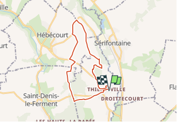
Randonnée Marche de 12,6 km à découvrir à Normandie, Eure, Bazincourt-sur-Epte. Cette randonnée est proposée par serge.guerroult.
Description
départ et arrivée devant l'entrée du château route de Sainte Marie .
la boucle emprunte le circuit de la mare Jaunet (bleu) le clos Aquain (rouge) et avant de rejoindre le Chaufour (jaune) un détour par la D17 et la plaine de la Culée
Localisation
Pays :
France
Région :
Normandie
Département/Province :
Eure
Commune :
Bazincourt-sur-Epte
Localité :
Unknown
Départ:(Dec)
Départ:(UTM)
410380 ; 5465257 (31U) N.
Commentaires
Randonnées à proximité
![Randonnée Marche Flavacourt - Flavacourt - Vexin Français - Photo](https://media.geolcdn.com/t/375/260/ext.jpg?maxdim=2&url=https%3A%2F%2Fservices.sitytrail.com%2FGeolivesWS%2FDownloadMedia.ashx%3FTrailID%3D107407%26Media%3D12316_3.jpg)
![Marche Marche](https://static1.geolcdn.com/sitytour/trail-icons/101.png)
Flavacourt - Vexin Français
Marche
Moyen
(1)
Flavacourt,
Hauts-de-France,
Oise,
France
![](/images/other/stat-length.png)
28 km | 33 km-effort
5h 30min
![](https://static1.geolcdn.com/siteimages/upload/files/16400158638029165_repeat_loop_refresh_sync_direction_icon.png)
Oui
![Randonnée Marche Saint-Denis-le-Ferment - Saint Denis le Ferment - chapelle de Ste Austreberte - Photo](https://media.geolcdn.com/t/375/260/ext.jpg?maxdim=2&url=https%3A%2F%2Fstatic1.geolcdn.com%2Fsiteimages%2Fupload%2Ffiles%2F1553511878bg_sport_marche.png)
![Marche Marche](https://static1.geolcdn.com/sitytour/trail-icons/101.png)
Saint Denis le Ferment - chapelle de Ste Austreberte
Marche
Moyen
(1)
Saint-Denis-le-Ferment,
Normandie,
Eure,
France
![](/images/other/stat-length.png)
7,7 km | 9,5 km-effort
2h 9min
![](https://static1.geolcdn.com/siteimages/upload/files/16400158638029165_repeat_loop_refresh_sync_direction_icon.png)
Oui
![Randonnée Marche Bézu-Saint-Éloi - Bézu Saint Eloi - Départ du parking route de Gisors (place St Eloi), puis Neaufles St martin - Photo](https://media.geolcdn.com/t/375/260/ext.jpg?maxdim=2&url=https%3A%2F%2Fstatic1.geolcdn.com%2Fsiteimages%2Fupload%2Ffiles%2F1553511878bg_sport_marche.png)
![Marche Marche](https://static1.geolcdn.com/sitytour/trail-icons/101.png)
Bézu Saint Eloi - Départ du parking route de Gisors (place St Eloi), puis Nea...
Marche
Moyen
(1)
Bézu-Saint-Éloi,
Normandie,
Eure,
France
![](/images/other/stat-length.png)
10,3 km | 12 km-effort
2h 43min
![](https://static1.geolcdn.com/siteimages/upload/files/16400158638029165_repeat_loop_refresh_sync_direction_icon.png)
Oui
![Randonnée Marche nordique Saint-Denis-le-Ferment - Marche Nordique 73 Saint Denis le Ferment - Photo](https://media.geolcdn.com/t/375/260/ext.jpg?maxdim=2&url=https%3A%2F%2Fstatic1.geolcdn.com%2Fsiteimages%2Fupload%2Ffiles%2F1545311037marcheuse_200dpi.jpg)
![Marche nordique Marche nordique](https://static1.geolcdn.com/sitytour/trail-icons/102.png)
Marche Nordique 73 Saint Denis le Ferment
Marche nordique
Très facile
(1)
Saint-Denis-le-Ferment,
Normandie,
Eure,
France
![](/images/other/stat-length.png)
9,9 km | 11,6 km-effort
1h 30min
![](https://static1.geolcdn.com/siteimages/upload/files/16400158638029165_repeat_loop_refresh_sync_direction_icon.png)
Oui
![Randonnée Marche Flavacourt - Flavacourt - le grand chêne et dolmen - Photo](https://media.geolcdn.com/t/375/260/ext.jpg?maxdim=2&url=https%3A%2F%2Fstatic1.geolcdn.com%2Fsiteimages%2Fupload%2Ffiles%2F1553511878bg_sport_marche.png)
![Marche Marche](https://static1.geolcdn.com/sitytour/trail-icons/101.png)
Flavacourt - le grand chêne et dolmen
Marche
Facile
(1)
Flavacourt,
Hauts-de-France,
Oise,
France
![](/images/other/stat-length.png)
9,7 km | 12,1 km-effort
2h 38min
![](https://static1.geolcdn.com/siteimages/upload/files/16400158638029165_repeat_loop_refresh_sync_direction_icon.png)
Oui
![Randonnée Marche Saint-Denis-le-Ferment - St Denis le Ferment - chateau de la Rapée - Photo](https://media.geolcdn.com/t/375/260/ext.jpg?maxdim=2&url=https%3A%2F%2Fstatic1.geolcdn.com%2Fsiteimages%2Fupload%2Ffiles%2F1553511878bg_sport_marche.png)
![Marche Marche](https://static1.geolcdn.com/sitytour/trail-icons/101.png)
St Denis le Ferment - chateau de la Rapée
Marche
Facile
(1)
Saint-Denis-le-Ferment,
Normandie,
Eure,
France
![](/images/other/stat-length.png)
9,3 km | 10,8 km-effort
2h 25min
![](https://static1.geolcdn.com/siteimages/upload/files/16400158638029165_repeat_loop_refresh_sync_direction_icon.png)
Oui
![Randonnée Marche Bazincourt-sur-Epte - Thierceville - chemin du clos Aquain - Photo](https://media.geolcdn.com/t/375/260/ext.jpg?maxdim=2&url=https%3A%2F%2Fstatic1.geolcdn.com%2Fsiteimages%2Fupload%2Ffiles%2F1553511878bg_sport_marche.png)
![Marche Marche](https://static1.geolcdn.com/sitytour/trail-icons/101.png)
Thierceville - chemin du clos Aquain
Marche
Facile
(1)
Bazincourt-sur-Epte,
Normandie,
Eure,
France
![](/images/other/stat-length.png)
9,2 km | 11,3 km-effort
2h 18min
![](https://static1.geolcdn.com/siteimages/upload/files/16400158638029165_repeat_loop_refresh_sync_direction_icon.png)
Oui
![Randonnée Marche Saint-Denis-le-Ferment - St Denis le Ferment - boucle courte la reine blanche - Photo](https://media.geolcdn.com/t/375/260/ext.jpg?maxdim=2&url=https%3A%2F%2Fstatic1.geolcdn.com%2Fsiteimages%2Fupload%2Ffiles%2F1553511878bg_sport_marche.png)
![Marche Marche](https://static1.geolcdn.com/sitytour/trail-icons/101.png)
St Denis le Ferment - boucle courte la reine blanche
Marche
Facile
(2)
Saint-Denis-le-Ferment,
Normandie,
Eure,
France
![](/images/other/stat-length.png)
7,4 km | 9 km-effort
2h 0min
![](https://static1.geolcdn.com/siteimages/upload/files/16400158638029165_repeat_loop_refresh_sync_direction_icon.png)
Oui
![Randonnée Marche Bézu-Saint-Éloi - Bézu Saint Eloi - Les Etangs de Neaufles - La tour de Neaufles - Photo](https://media.geolcdn.com/t/375/260/93585773-80a0-4bed-be31-5cac038d12c5.jpg&format=jpg&maxdim=2)
![Marche Marche](https://static1.geolcdn.com/sitytour/trail-icons/101.png)
Bézu Saint Eloi - Les Etangs de Neaufles - La tour de Neaufles
Marche
Difficile
Bézu-Saint-Éloi,
Normandie,
Eure,
France
![](/images/other/stat-length.png)
10,6 km | 12,4 km-effort
2h 37min
![](https://static1.geolcdn.com/siteimages/upload/files/16400158638029165_repeat_loop_refresh_sync_direction_icon.png)
Oui