![](/images/other/stat-length.png)
![Randonnée Marche Foncine-le-Haut - GTJura - Photo](https://media.geolcdn.com/t/1900/400/ext.pjpeg?maxdim=2&url=https%3A%2F%2Fstatic1.geolcdn.com%2Fsiteimages%2Fupload%2Ffiles%2F1553511878bg_sport_marche.png)
GTJura
nfranche
Utilisateur
![Longueur](/images/other/stat-length.png)
Longueur
19,7 km
![Altitude max](https://static1.geolcdn.com/siteimages/upload/files/1508320355ic_sort_altitude_max_24dp.png)
Altitude max
1183 m
![Dénivelé positif](https://static1.geolcdn.com/siteimages/upload/files/1508320355ic_sort_den_pos_24dp.png)
Dénivelé positif
589 m
![Km-Effort](/images/other/stat-length.png)
Km-Effort
27 km
![Altitude min](https://static1.geolcdn.com/siteimages/upload/files/1508320355ic_sort_altitude_min_24dp.png)
Altitude min
861 m
![Dénivelé négatif](https://static1.geolcdn.com/siteimages/upload/files/1508320355ic_sort_den_neg_24dp.png)
Dénivelé négatif
421 m
![Boucle](https://static1.geolcdn.com/siteimages/upload/files/16400158638029165_repeat_loop_refresh_sync_direction_icon.png)
Boucle
Non
Date de création :
2014-12-10 00:00:00.0
Dernière modification :
2014-12-10 00:00:00.0
![Marche](https://static1.geolcdn.com/sitytour/trail-icons/101.png)
5h41
Difficulté : Moyen
![Scannez ce code QR pour ouvrir la randonnée dans l'application SityTrail](https://capi.geolives.com/qq0zvz2zws4bq2lad0pu/sitytour/trails/323130/qr.png?size=200)
Application GPS de randonnée GRATUITE
À propos
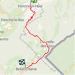
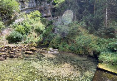
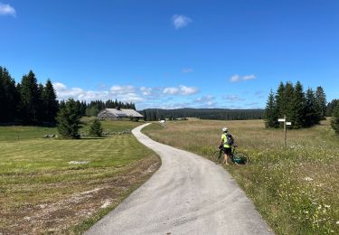
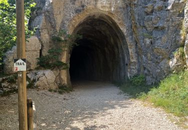
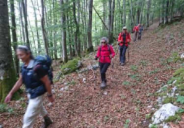
Randonnée Marche de 19,7 km à découvrir à Bourgogne-Franche-Comté, Jura, Foncine-le-Haut. Cette randonnée est proposée par nfranche.
Description
La Grande Traversée du Jura de Pontarlier à Bellegarde-sur-ValserineEtape 4 : Foncine-le-haut - Bellefontaine
Localisation
Pays :
France
Région :
Bourgogne-Franche-Comté
Département/Province :
Jura
Commune :
Foncine-le-Haut
Localité :
Unknown
Départ:(Dec)
Départ:(UTM)
276134 ; 5171402 (32T) N.
Commentaires
Randonnées à proximité
![Randonnée Marche Chaux-Neuve - Chaux Neuve - cascade Bief Bridaux - tremplin - Photo](https://media.geolcdn.com/t/375/260/f4e28690-c7d4-4ed2-b2e7-b91b4307e6b7.jpg&format=jpg&maxdim=2)
![Marche Marche](https://static1.geolcdn.com/sitytour/trail-icons/101.png)
Chaux Neuve - cascade Bief Bridaux - tremplin
Marche
Difficile
(1)
Chaux-Neuve,
Bourgogne-Franche-Comté,
Doubs,
France
![](/images/other/stat-length.png)
9,1 km | 12,5 km-effort
2h 50min
![](https://static1.geolcdn.com/siteimages/upload/files/16400158638029165_repeat_loop_refresh_sync_direction_icon.png)
Oui
![Randonnée Marche Les Planches-en-Montagne - Gorges de la Saine - Les Planches en Montagne - Photo](https://media.geolcdn.com/t/375/260/ext.jpg?maxdim=2&url=https%3A%2F%2Fservices.sitytrail.com%2FGeolivesWS%2FDownloadMedia.ashx%3FTrailID%3D317645%26Media%3D16918_6.jpg)
![Marche Marche](https://static1.geolcdn.com/sitytour/trail-icons/101.png)
Gorges de la Saine - Les Planches en Montagne
Marche
Facile
(4)
Les Planches-en-Montagne,
Bourgogne-Franche-Comté,
Jura,
France
![](/images/other/stat-length.png)
6,1 km | 8,1 km-effort
2h 30min
![](https://static1.geolcdn.com/siteimages/upload/files/16400158638029165_repeat_loop_refresh_sync_direction_icon.png)
Oui
![Randonnée Marche Foncine-le-Haut - Circuit Creux Maldru - Photo](https://media.geolcdn.com/t/375/260/c5572b14-7842-4c9a-a4fb-45327348d69a.jpg&format=jpg&maxdim=2)
![Marche Marche](https://static1.geolcdn.com/sitytour/trail-icons/101.png)
Circuit Creux Maldru
Marche
Foncine-le-Haut,
Bourgogne-Franche-Comté,
Jura,
France
![](/images/other/stat-length.png)
14,7 km | 20 km-effort
5h 32min
![](https://static1.geolcdn.com/siteimages/upload/files/16400158638029165_repeat_loop_refresh_sync_direction_icon.png)
Oui
![Randonnée V.T.T. Foncine-le-Haut - Jura 2 - Photo](https://media.geolcdn.com/t/375/260/8eab54f3-443c-4436-ad02-6f2dcf41b1ff.jpg&format=jpg&maxdim=2)
![V.T.T. V.T.T.](https://static1.geolcdn.com/sitytour/trail-icons/202.png)
Jura 2
V.T.T.
Très difficile
Foncine-le-Haut,
Bourgogne-Franche-Comté,
Jura,
France
![](/images/other/stat-length.png)
37 km | 46 km-effort
4h 20min
![](https://static1.geolcdn.com/siteimages/upload/files/16400158638029165_repeat_loop_refresh_sync_direction_icon.png)
Non
![Randonnée V.T.T. Foncine-le-Haut - Jura 1 - Photo](https://media.geolcdn.com/t/375/260/eb748db3-1e12-4544-bd9f-6a30da2eb7e1.jpg&format=jpg&maxdim=2)
![V.T.T. V.T.T.](https://static1.geolcdn.com/sitytour/trail-icons/202.png)
Jura 1
V.T.T.
Difficile
Foncine-le-Haut,
Bourgogne-Franche-Comté,
Jura,
France
![](/images/other/stat-length.png)
32 km | 40 km-effort
4h 45min
![](https://static1.geolcdn.com/siteimages/upload/files/16400158638029165_repeat_loop_refresh_sync_direction_icon.png)
Oui
![Randonnée Marche Foncine-le-Bas - Foncines-le-Bas, du viaduc des Douanets à la cascade du Bief de la Ruine. - Photo](https://media.geolcdn.com/t/375/260/606c1e83-67b7-4855-afa2-efec7122554e.jpg&format=jpg&maxdim=2)
![Marche Marche](https://static1.geolcdn.com/sitytour/trail-icons/101.png)
Foncines-le-Bas, du viaduc des Douanets à la cascade du Bief de la Ruine.
Marche
Facile
Foncine-le-Bas,
Bourgogne-Franche-Comté,
Jura,
France
![](/images/other/stat-length.png)
3,6 km | 4,9 km-effort
2h 21min
![](https://static1.geolcdn.com/siteimages/upload/files/16400158638029165_repeat_loop_refresh_sync_direction_icon.png)
Oui
![Randonnée Marche Foncine-le-Bas - Foncine-le-bas, Les Planches enMontagne - Photo](https://media.geolcdn.com/t/375/260/ext.jpg?maxdim=2&url=https%3A%2F%2Fservices.sitytrail.com%2FGeolivesWS%2FDownloadMedia.ashx%3FTrailID%3D1053204%26Media%3Dfix__20180912112148.jpg)
![Marche Marche](https://static1.geolcdn.com/sitytour/trail-icons/101.png)
Foncine-le-bas, Les Planches enMontagne
Marche
Facile
Foncine-le-Bas,
Bourgogne-Franche-Comté,
Jura,
France
![](/images/other/stat-length.png)
6 km | 8 km-effort
1h 43min
![](https://static1.geolcdn.com/siteimages/upload/files/16400158638029165_repeat_loop_refresh_sync_direction_icon.png)
Oui
![Randonnée Autre activité Foncine-le-Bas - SVG 180617 - Photo](https://media.geolcdn.com/t/375/260/ext.jpg?maxdim=2&url=https%3A%2F%2Fservices.sitytrail.com%2FGeolivesWS%2FDownloadMedia.ashx%3FTrailID%3D988379%26Media%3Dfix__20180617151246.jpg)
![Autre activité Autre activité](https://static1.geolcdn.com/sitytour/trail-icons/900.png)
SVG 180617
Autre activité
Très facile
Foncine-le-Bas,
Bourgogne-Franche-Comté,
Jura,
France
![](/images/other/stat-length.png)
12,4 km | 16,5 km-effort
6h 1min
![](https://static1.geolcdn.com/siteimages/upload/files/16400158638029165_repeat_loop_refresh_sync_direction_icon.png)
Oui
![Randonnée Marche Foncine-le-Haut - Sur les hauteurs de Foncine - Photo](https://media.geolcdn.com/t/375/260/ext.jpg?maxdim=2&url=https%3A%2F%2Fstatic1.geolcdn.com%2Fsiteimages%2Fupload%2Ffiles%2F1553511878bg_sport_marche.png)
![Marche Marche](https://static1.geolcdn.com/sitytour/trail-icons/101.png)
Sur les hauteurs de Foncine
Marche
Très facile
(1)
Foncine-le-Haut,
Bourgogne-Franche-Comté,
Jura,
France
![](/images/other/stat-length.png)
13,5 km | 18,2 km-effort
3h 58min
![](https://static1.geolcdn.com/siteimages/upload/files/16400158638029165_repeat_loop_refresh_sync_direction_icon.png)
Oui