![](/images/other/stat-length.png)
![Randonnée Marche Théoule-sur-Mer - Autour de Theoule - Photo](https://media.geolcdn.com/t/1900/400/666591e4-2725-4c04-a89b-4cb9ff7f44d7.jpg&format=pjpeg&maxdim=2)
Autour de Theoule
ETMU5496
Utilisateur
![Longueur](/images/other/stat-length.png)
Longueur
23 km
![Altitude max](https://static1.geolcdn.com/siteimages/upload/files/1508320355ic_sort_altitude_max_24dp.png)
Altitude max
437 m
![Dénivelé positif](https://static1.geolcdn.com/siteimages/upload/files/1508320355ic_sort_den_pos_24dp.png)
Dénivelé positif
1115 m
![Km-Effort](/images/other/stat-length.png)
Km-Effort
38 km
![Altitude min](https://static1.geolcdn.com/siteimages/upload/files/1508320355ic_sort_altitude_min_24dp.png)
Altitude min
0 m
![Dénivelé négatif](https://static1.geolcdn.com/siteimages/upload/files/1508320355ic_sort_den_neg_24dp.png)
Dénivelé négatif
1113 m
![Boucle](https://static1.geolcdn.com/siteimages/upload/files/16400158638029165_repeat_loop_refresh_sync_direction_icon.png)
Boucle
Oui
Date de création :
2022-05-04 06:26:59.0
Dernière modification :
2022-05-05 08:14:46.04
![Marche](https://static1.geolcdn.com/sitytour/trail-icons/101.png)
5h48
Difficulté : Moyen
![Scannez ce code QR pour ouvrir la randonnée dans l'application SityTrail](https://capi.geolives.com/qq0zvz2zws4bq2lad0pu/sitytour/trails/3229255/qr.png?size=200)
Application GPS de randonnée GRATUITE
À propos
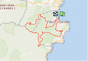
Randonnée Marche de 23 km à découvrir à Provence-Alpes-Côte d'Azur, Alpes-Maritimes, Théoule-sur-Mer. Cette randonnée est proposée par ETMU5496.
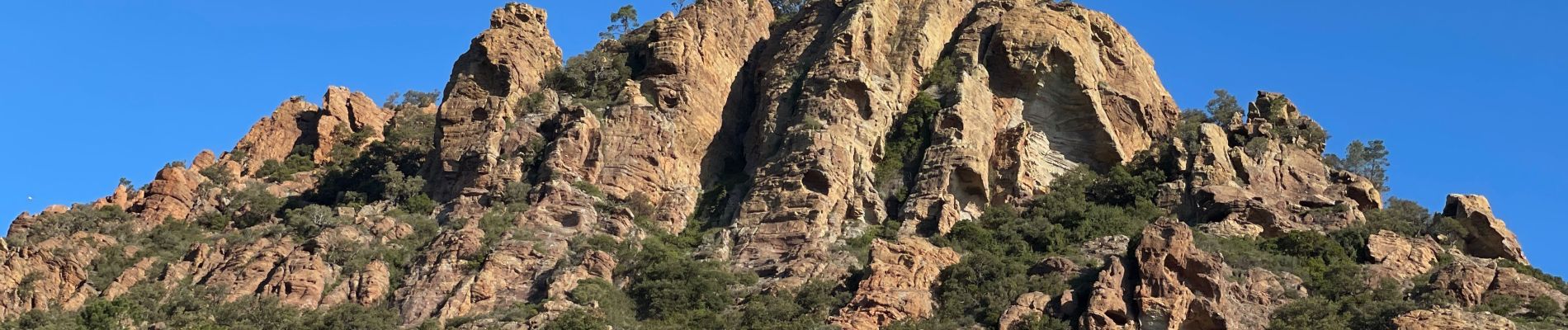
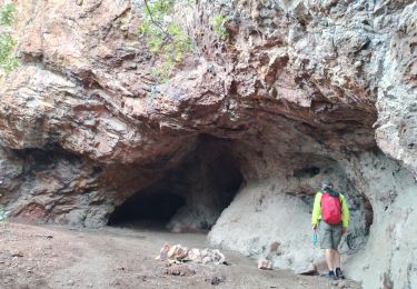
Description
Rocher des Monges
Maure Vieil
Pont Sarrazin
Piste des oeufs de bouc
col de la cadière
Les grues
ND d'Afrique
Localisation
Pays :
France
Région :
Provence-Alpes-Côte d'Azur
Département/Province :
Alpes-Maritimes
Commune :
Théoule-sur-Mer
Localité :
Unknown
Départ:(Dec)
Départ:(UTM)
333580 ; 4819348 (32T) N.
Commentaires
Randonnées à proximité
![Randonnée Marche Mandelieu-la-Napoule - Mont Saint Martin - Photo](https://media.geolcdn.com/t/375/260/ext.jpg?maxdim=2&url=https%3A%2F%2Fservices.sitytrail.com%2FGeolivesWS%2FDownloadMedia.ashx%3FTrailID%3D203071%26Media%3Dfix__20130706124443.jpg)
![Marche Marche](https://static1.geolcdn.com/sitytour/trail-icons/101.png)
Mont Saint Martin
Marche
Facile
(1)
Mandelieu-la-Napoule,
Provence-Alpes-Côte d'Azur,
Alpes-Maritimes,
France
![](/images/other/stat-length.png)
9 km | 14,2 km-effort
3h 0min
![](https://static1.geolcdn.com/siteimages/upload/files/16400158638029165_repeat_loop_refresh_sync_direction_icon.png)
Oui
![Randonnée Marche Saint-Raphaël - Théoule ND - Aiguille - Photo](https://media.geolcdn.com/t/375/260/ext.jpg?maxdim=2&url=https%3A%2F%2Fstatic1.geolcdn.com%2Fsiteimages%2Fupload%2Ffiles%2F1553511878bg_sport_marche.png)
![Marche Marche](https://static1.geolcdn.com/sitytour/trail-icons/101.png)
Théoule ND - Aiguille
Marche
Très difficile
(1)
Saint-Raphaël,
Provence-Alpes-Côte d'Azur,
Var,
France
![](/images/other/stat-length.png)
18,1 km | 29 km-effort
6h 40min
![](https://static1.geolcdn.com/siteimages/upload/files/16400158638029165_repeat_loop_refresh_sync_direction_icon.png)
Oui
![Randonnée Marche Saint-Raphaël - Tour du Pic de l'Ours - Le Trayas - Photo](https://media.geolcdn.com/t/375/260/ext.jpg?maxdim=2&url=https%3A%2F%2Fservices.sitytrail.com%2FGeolivesWS%2FDownloadMedia.ashx%3FTrailID%3D191486%26Media%3D15078_2.jpg)
![Marche Marche](https://static1.geolcdn.com/sitytour/trail-icons/101.png)
Tour du Pic de l'Ours - Le Trayas
Marche
Moyen
(1)
Saint-Raphaël,
Provence-Alpes-Côte d'Azur,
Var,
France
![](/images/other/stat-length.png)
9,5 km | 16 km-effort
3h 0min
![](https://static1.geolcdn.com/siteimages/upload/files/16400158638029165_repeat_loop_refresh_sync_direction_icon.png)
Oui
![Randonnée A pied Théoule-sur-Mer - Tracé Rocher des Monges par col de Théoule - Photo](https://media.geolcdn.com/t/375/260/ext.jpg?maxdim=2&url=https%3A%2F%2Fstatic1.geolcdn.com%2Fsiteimages%2Fupload%2Ffiles%2F1545311037marcheuse_200dpi.jpg)
![A pied A pied](https://static1.geolcdn.com/sitytour/trail-icons/100.png)
Tracé Rocher des Monges par col de Théoule
A pied
Très facile
(1)
Théoule-sur-Mer,
Provence-Alpes-Côte d'Azur,
Alpes-Maritimes,
France
![](/images/other/stat-length.png)
7,2 km | 11,2 km-effort
Inconnu
![](https://static1.geolcdn.com/siteimages/upload/files/16400158638029165_repeat_loop_refresh_sync_direction_icon.png)
Oui
![Randonnée Marche Théoule-sur-Mer - Théoule-sur-mer - Sommets des Grues Col Notre-Dame - 14.7km 625m 4h30 (0h45) - 2015 06 08 - Photo](https://media.geolcdn.com/t/375/260/ext.jpg?maxdim=2&url=https%3A%2F%2Fservices.sitytrail.com%2FGeolivesWS%2FDownloadMedia.ashx%3FTrailID%3D435398%26Media%3Dfix__20150608121929.jpg)
![Marche Marche](https://static1.geolcdn.com/sitytour/trail-icons/101.png)
Théoule-sur-mer - Sommets des Grues Col Notre-Dame - 14.7km 625m 4h30 (0h45) ...
Marche
Moyen
Théoule-sur-Mer,
Provence-Alpes-Côte d'Azur,
Alpes-Maritimes,
France
![](/images/other/stat-length.png)
14,7 km | 23 km-effort
4h 30min
![](https://static1.geolcdn.com/siteimages/upload/files/16400158638029165_repeat_loop_refresh_sync_direction_icon.png)
Oui
![Randonnée Marche Saint-Raphaël - pic de l'ours pic d' aurelle - Photo](https://media.geolcdn.com/t/375/260/ext.jpg?maxdim=2&url=https%3A%2F%2Fstatic1.geolcdn.com%2Fsiteimages%2Fupload%2Ffiles%2F1553511878bg_sport_marche.png)
![Marche Marche](https://static1.geolcdn.com/sitytour/trail-icons/101.png)
pic de l'ours pic d' aurelle
Marche
Moyen
(2)
Saint-Raphaël,
Provence-Alpes-Côte d'Azur,
Var,
France
![](/images/other/stat-length.png)
10,8 km | 17,7 km-effort
4h 3min
![](https://static1.geolcdn.com/siteimages/upload/files/16400158638029165_repeat_loop_refresh_sync_direction_icon.png)
Oui
![Randonnée Marche Mandelieu-la-Napoule -](https://media.geolcdn.com/t/375/260/b86348bf-abb5-455a-82e4-681ad648fdf1.jpg&format=jpg&maxdim=2)
![Marche Marche](https://static1.geolcdn.com/sitytour/trail-icons/101.png)
"Les oeufs de bouc"
Marche
Moyen
Mandelieu-la-Napoule,
Provence-Alpes-Côte d'Azur,
Alpes-Maritimes,
France
![](/images/other/stat-length.png)
14,5 km | 22 km-effort
6h 42min
![](https://static1.geolcdn.com/siteimages/upload/files/16400158638029165_repeat_loop_refresh_sync_direction_icon.png)
Oui
![Randonnée Marche Mandelieu-la-Napoule - châteaux de la Napoule - Photo](https://media.geolcdn.com/t/375/260/0390d912-0cc3-4a3a-a76c-b7a4f5d42e4b.jpg&format=jpg&maxdim=2)
![Marche Marche](https://static1.geolcdn.com/sitytour/trail-icons/101.png)
châteaux de la Napoule
Marche
Facile
Mandelieu-la-Napoule,
Provence-Alpes-Côte d'Azur,
Alpes-Maritimes,
France
![](/images/other/stat-length.png)
5,6 km | 7,8 km-effort
2h 23min
![](https://static1.geolcdn.com/siteimages/upload/files/16400158638029165_repeat_loop_refresh_sync_direction_icon.png)
Oui
![Randonnée Marche Saint-Raphaël - agay. Le pic des ours depuis la col du lantisque - Photo](https://media.geolcdn.com/t/375/260/b13e32ef-2546-4c6f-a5fd-9a287b511ff6.jpg&format=jpg&maxdim=2)
![Marche Marche](https://static1.geolcdn.com/sitytour/trail-icons/101.png)
agay. Le pic des ours depuis la col du lantisque
Marche
Difficile
Saint-Raphaël,
Provence-Alpes-Côte d'Azur,
Var,
France
![](/images/other/stat-length.png)
10,6 km | 16,8 km-effort
5h 43min
![](https://static1.geolcdn.com/siteimages/upload/files/16400158638029165_repeat_loop_refresh_sync_direction_icon.png)
Oui