![](/images/other/stat-length.png)
![Randonnée Marche Bargemon - Les bois de Favas et de Coste Rousse 2 - Photo](https://media.geolcdn.com/t/1900/400/c9395baa-04ee-457b-ac26-f4338b707991.jpg&format=pjpeg&maxdim=2)
Les bois de Favas et de Coste Rousse 2
boulinevelyne
Utilisateur
![Longueur](/images/other/stat-length.png)
Longueur
11,7 km
![Altitude max](https://static1.geolcdn.com/siteimages/upload/files/1508320355ic_sort_altitude_max_24dp.png)
Altitude max
736 m
![Dénivelé positif](https://static1.geolcdn.com/siteimages/upload/files/1508320355ic_sort_den_pos_24dp.png)
Dénivelé positif
414 m
![Km-Effort](/images/other/stat-length.png)
Km-Effort
17,2 km
![Altitude min](https://static1.geolcdn.com/siteimages/upload/files/1508320355ic_sort_altitude_min_24dp.png)
Altitude min
464 m
![Dénivelé négatif](https://static1.geolcdn.com/siteimages/upload/files/1508320355ic_sort_den_neg_24dp.png)
Dénivelé négatif
415 m
![Boucle](https://static1.geolcdn.com/siteimages/upload/files/16400158638029165_repeat_loop_refresh_sync_direction_icon.png)
Boucle
Oui
Date de création :
2022-05-04 06:47:30.634
Dernière modification :
2023-04-13 14:59:24.547
![Marche](https://static1.geolcdn.com/sitytour/trail-icons/101.png)
3h43
Difficulté : Moyen
![Scannez ce code QR pour ouvrir la randonnée dans l'application SityTrail](https://capi.geolives.com/qq0zvz2zws4bq2lad0pu/sitytour/trails/3228957/qr.png?size=200)
Application GPS de randonnée GRATUITE
À propos
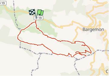
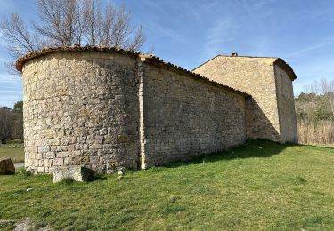
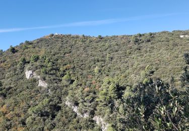
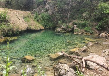
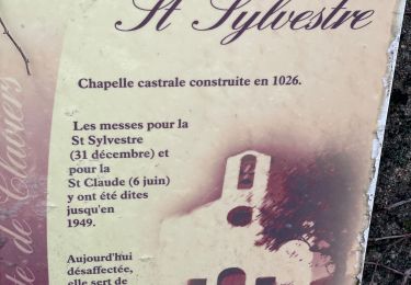
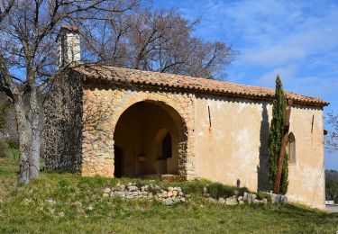
Randonnée Marche de 11,7 km à découvrir à Provence-Alpes-Côte d'Azur, Var, Bargemon. Cette randonnée est proposée par boulinevelyne.
Description
A hauteur du point 469 prendre la D 25 sur 400m et retrouver la piste. Une propriété privé empêche de suivre le tracé.
Localisation
Pays :
France
Région :
Provence-Alpes-Côte d'Azur
Département/Province :
Var
Commune :
Bargemon
Localité :
Unknown
Départ:(Dec)
Départ:(UTM)
299801 ; 4833018 (32T) N.
Commentaires
Randonnées à proximité
![Randonnée Marche Figanières - château château de château de la garde - Photo](https://media.geolcdn.com/t/375/260/ext.jpg?maxdim=2&url=https%3A%2F%2Fstatic1.geolcdn.com%2Fsiteimages%2Fupload%2Ffiles%2F1553511878bg_sport_marche.png)
![Marche Marche](https://static1.geolcdn.com/sitytour/trail-icons/101.png)
château château de château de la garde
Marche
Très facile
(1)
Figanières,
Provence-Alpes-Côte d'Azur,
Var,
France
![](/images/other/stat-length.png)
9,2 km | 11,9 km-effort
2h 48min
![](https://static1.geolcdn.com/siteimages/upload/files/16400158638029165_repeat_loop_refresh_sync_direction_icon.png)
Oui
![Randonnée Marche Callas - Callas, Chapelle St Auxile, forêt de l'Ubac - Photo](https://media.geolcdn.com/t/375/260/26d09189-0caa-495a-ab54-70d3156a8274.jpg&format=jpg&maxdim=2)
![Marche Marche](https://static1.geolcdn.com/sitytour/trail-icons/101.png)
Callas, Chapelle St Auxile, forêt de l'Ubac
Marche
Facile
Callas,
Provence-Alpes-Côte d'Azur,
Var,
France
![](/images/other/stat-length.png)
10,1 km | 13,6 km-effort
3h 9min
![](https://static1.geolcdn.com/siteimages/upload/files/16400158638029165_repeat_loop_refresh_sync_direction_icon.png)
Oui
![Randonnée Marche Callas - Callas- Autour de la Chapelle Saint-Auxile - Photo](https://media.geolcdn.com/t/375/260/39191c0e-36f1-45df-a6f2-79eb92bea507.jpg&format=jpg&maxdim=2)
![Marche Marche](https://static1.geolcdn.com/sitytour/trail-icons/101.png)
Callas- Autour de la Chapelle Saint-Auxile
Marche
Moyen
Callas,
Provence-Alpes-Côte d'Azur,
Var,
France
![](/images/other/stat-length.png)
6,4 km | 9,5 km-effort
2h 9min
![](https://static1.geolcdn.com/siteimages/upload/files/16400158638029165_repeat_loop_refresh_sync_direction_icon.png)
Oui
![Randonnée Marche Callas - Callas fait - Photo](https://media.geolcdn.com/t/375/260/e068010e-7c1e-4823-8adc-09610ec694e8.jpg&format=jpg&maxdim=2)
![Marche Marche](https://static1.geolcdn.com/sitytour/trail-icons/101.png)
Callas fait
Marche
Moyen
Callas,
Provence-Alpes-Côte d'Azur,
Var,
France
![](/images/other/stat-length.png)
20 km | 31 km-effort
6h 55min
![](https://static1.geolcdn.com/siteimages/upload/files/16400158638029165_repeat_loop_refresh_sync_direction_icon.png)
Oui
![Randonnée Marche Montferrat - La double Borie et le Beaudron . Montferrat - Photo](https://media.geolcdn.com/t/375/260/37fe677f-7514-43b8-99bc-ecf459b0d0c6.jpg&format=jpg&maxdim=2)
![Marche Marche](https://static1.geolcdn.com/sitytour/trail-icons/101.png)
La double Borie et le Beaudron . Montferrat
Marche
Difficile
(1)
Montferrat,
Provence-Alpes-Côte d'Azur,
Var,
France
![](/images/other/stat-length.png)
9,1 km | 14,3 km-effort
3h 15min
![](https://static1.geolcdn.com/siteimages/upload/files/16400158638029165_repeat_loop_refresh_sync_direction_icon.png)
Oui
![Randonnée sport Montferrat - M’ingérât - Photo](https://media.geolcdn.com/t/375/260/eddb71a8-a450-480a-bcb7-b957fb1c6ca4.jpg&format=jpg&maxdim=2)
M’ingérât
sport
Très facile
Montferrat,
Provence-Alpes-Côte d'Azur,
Var,
France
![](/images/other/stat-length.png)
11,6 km | 17,2 km-effort
Inconnu
![](https://static1.geolcdn.com/siteimages/upload/files/16400158638029165_repeat_loop_refresh_sync_direction_icon.png)
Oui
![Randonnée Marche Montferrat - 20-06-2023 Pierrepont - Photo](https://media.geolcdn.com/t/375/260/034012e7-d79a-49bd-8eb6-f013b2431da1.jpg&format=jpg&maxdim=2)
![Marche Marche](https://static1.geolcdn.com/sitytour/trail-icons/101.png)
20-06-2023 Pierrepont
Marche
Facile
Montferrat,
Provence-Alpes-Côte d'Azur,
Var,
France
![](/images/other/stat-length.png)
12,4 km | 18,3 km-effort
4h 8min
![](https://static1.geolcdn.com/siteimages/upload/files/16400158638029165_repeat_loop_refresh_sync_direction_icon.png)
Oui
![Randonnée Marche Claviers - Claviers - St Arnoux - Photo](https://media.geolcdn.com/t/375/260/f7220a43-8738-4782-989f-a964d901faaf.jpg&format=jpg&maxdim=2)
![Marche Marche](https://static1.geolcdn.com/sitytour/trail-icons/101.png)
Claviers - St Arnoux
Marche
Moyen
Claviers,
Provence-Alpes-Côte d'Azur,
Var,
France
![](/images/other/stat-length.png)
18 km | 26 km-effort
4h 2min
![](https://static1.geolcdn.com/siteimages/upload/files/16400158638029165_repeat_loop_refresh_sync_direction_icon.png)
Oui
![Marche Marche](https://static1.geolcdn.com/sitytour/trail-icons/101.png)
Bargemon - ND - Ste Anne de Claviers - Chapelle St Arnoux
Marche
Facile
Bargemon,
Provence-Alpes-Côte d'Azur,
Var,
France
![](/images/other/stat-length.png)
19,9 km | 29 km-effort
4h 29min
![](https://static1.geolcdn.com/siteimages/upload/files/16400158638029165_repeat_loop_refresh_sync_direction_icon.png)
Oui