Randonnée Marche Hal - #170410 - Bois de Hal - Achtdreven Rilroheide Tranendal**** - Photo

#170410 - Bois de Hal - Achtdreven Rilroheide Tranendal****

 Randos Ouvertes
Randos Ouvertes

Utilisateur

© OpenStreetMap contributors
Longueur
Longueur
8,4 km
Altitude max
Altitude max
140 m
Dénivelé positif
Dénivelé positif
121 m
Km-Effort
Km-Effort  
10 km
Altitude min
Altitude min
94 m
Dénivelé négatif
Dénivelé négatif
122 m
Boucle
Boucle
Oui
Date de création :
2022-04-19 19:28:00.004
Dernière modification :
2022-04-19 19:34:01.388

(1 Avis)

Marche
Marche
2h16
Difficulté : Moyen

Scannez ce code QR pour ouvrir la randonnée dans l'application SityTrail

Application GPS de randonnée GRATUITE

Logo SityTrail SityTrail

IGN / Instituts géographiques

Télécharger SityTrail sur l'App Store Télécharger SityTrail sur Google Play

Logo SityTrail SityTrail World

Le monde est à vous

Télécharger SityTrail sur l'App Store Télécharger SityTrail sur Google Play Télécharger SityTrail sur Huawei AppGallery

À propos

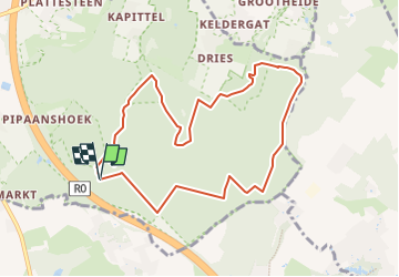
Randonnée Marche de 8,4 km à découvrir à Flandre, Brabant flamand, Hal. Cette randonnée est proposée par Randos Ouvertes.

Description

Belle promenade variée, donnant une vue complète des différentes atmosphères "magiques" du bois de Hal. Départ/arrivée depuis l'avant-dernière zone de parking, Vlasmarktdreef (côté Hal) avant d'arriver à la barrière des Achtdreven. Ce parking se trouve à doite de la Vlamarktdreef après les parkings n° 2 et 3 du côté ouest du bois (accès par N28 Braine-le-Château/Hal). Magique à la floraison des jacynthes (fin avril début mai) mais vaut la peine en toutes saisons.

Profil altimétrique

Points d'intérêt

Point d'intérêt Hal - Bois de Hal - Photo
Randos Ouvertes

Localisation

Pays :
Belgique
Région :
Flandre
Département/Province :
Brabant flamand
Commune :
Hal
Localité :
Unknown
Départ:(Dec)
Départ:(UTM)
590370 ; 5617411 (31U) N.

Commentaires

Veuillez vous connecter pour laisser un commentaire ou une note


Randonnées à proximité

Randonnée Marche Braine-le-Château - RB-Bw-14_Braine-le-Château_via-racc-2 - Photo
Marche
PRO

Marche

Très difficile
(6)
Braine-le-Château, Wallonie, Brabant wallon, Belgique
17,1 km | 22 km-effort
4h 56min
Oui
Randonnée Marche Braine-le-Château - RB-Bw-14_Braine-le-Château - Photo
Marche
PRO

Marche

Très difficile
(7)
Braine-le-Château, Wallonie, Brabant wallon, Belgique
23 km | 29 km-effort
6h 30min
Oui
Randonnée Marche Braine-l'Alleud - RB-Bw-13_Braine-l'Alleud - Photo
Marche
PRO

Marche

Très difficile
(5)
Braine-l'Alleud, Wallonie, Brabant wallon, Belgique
21 km | 27 km-effort
6h 2min
Oui
Randonnée Marche Braine-le-Château - RB-Bw-14_Braine-le-Château_via-racc-1 - Photo
Marche
PRO

Marche

Difficile
(12)
Braine-le-Château, Wallonie, Brabant wallon, Belgique
11,2 km | 14,9 km-effort
3h 22min
Oui
Randonnée Marche Braine-l'Alleud - RB-Bw-13_Braine-l'Alleud_via-racc-1-et-var - Photo
Marche
PRO

Marche

Difficile
(6)
Braine-l'Alleud, Wallonie, Brabant wallon, Belgique
14,8 km | 18,8 km-effort
4h 16min
Oui
Randonnée Marche Braine-le-Château - Marche Adeps á  Braine-le-Château  - Photo
Marche
GUIDE
Desrumaux

Marche

Très facile
(1)
Braine-le-Château, Wallonie, Brabant wallon, Belgique
10,5 km | 13,7 km-effort
3h 6min
Oui
Randonnée Marche Braine-le-Château - Balade à Braine-le-Château - Photo
Marche
GUIDE
Desrumaux

Marche

Facile
(2)
Braine-le-Château, Wallonie, Brabant wallon, Belgique
10,8 km | 13,7 km-effort
3h 0min
Oui
Randonnée Marche Hal - Balade dans le Bois de Halle - Photo
Marche
GUIDE
Desrumaux

Marche

Facile
(2)
Hal, Flandre, Brabant flamand, Belgique
8,6 km | 10,5 km-effort
2h 14min
Oui
Randonnée Marche Braine-le-Château - #201214 - Braine-le-Château, Les Monts, Les Fonds et Bruyère Landuyt - Photo
Marche
Randos Ouvertes

Marche

Moyen
(1)
Braine-le-Château, Wallonie, Brabant wallon, Belgique
7,8 km | 10,2 km-effort
2h 11min
Oui


Fermer
Mes abonnements