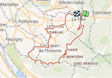
![](/images/other/stat-length.png)
![Randonnée Marche La Tour - 17-04-2022 Le tour de Saint Jean de Tholomé - Photo](https://media.geolcdn.com/t/1900/400/afe0a2c8-09a9-438d-add3-0f8a286a78fb.jpg&format=pjpeg&maxdim=2)
17-04-2022 Le tour de Saint Jean de Tholomé
Kargil
Utilisateur GUIDE
![Longueur](/images/other/stat-length.png)
![Altitude max](https://static1.geolcdn.com/siteimages/upload/files/1508320355ic_sort_altitude_max_24dp.png)
![Dénivelé positif](https://static1.geolcdn.com/siteimages/upload/files/1508320355ic_sort_den_pos_24dp.png)
![Km-Effort](/images/other/stat-length.png)
![Altitude min](https://static1.geolcdn.com/siteimages/upload/files/1508320355ic_sort_altitude_min_24dp.png)
![Dénivelé négatif](https://static1.geolcdn.com/siteimages/upload/files/1508320355ic_sort_den_neg_24dp.png)
![Boucle](https://static1.geolcdn.com/siteimages/upload/files/16400158638029165_repeat_loop_refresh_sync_direction_icon.png)
![Marche](https://static1.geolcdn.com/sitytour/trail-icons/101.png)
5h19
Difficulté : Difficile
![Scannez ce code QR pour ouvrir la randonnée dans l'application SityTrail](https://capi.geolives.com/qq0zvz2zws4bq2lad0pu/sitytour/trails/3208217/qr.png?size=200)
Application GPS de randonnée GRATUITE
À propos
Randonnée Marche de 21 km à découvrir à Auvergne-Rhône-Alpes, Haute-Savoie, La Tour. Cette randonnée est proposée par Kargil.
Description
Les moins :
-Un premier tiers sur routes de campagne goudronnées avec peu de passage et majoritairement possibilité de marcher sur le bas côté en herbe.
-Des travaux forestiers ont largement modifiés la cartographie
Les plus :
-Une distance non négligeable avec un dénivelé correct
-De belles vues de Alpes à Jura puis Jura à Alpes
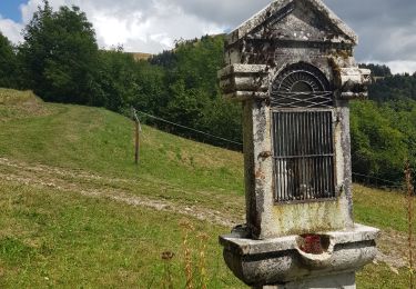
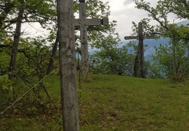
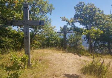
-Des lieux remarquables comme le chemin de croix d'Orgevat
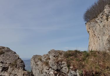
-Des travaux forestiers qui ont permis un itinéraire hors sentier (sur l'arrête du Dard et au Chargieux)
Le sentier pointillé à gauche du point 1048 n'existe plus. La descente se fait en ligne droite dans une belle pente.
Un détour par Le Grand Château depuis le Reray (il suffit de continuer tout droit) peut constituer un beau bonus.
Localisation
Commentaires
Randonnées à proximité
![Randonnée Marche Viuz-en-Sallaz - Viuz-Les Brasses-Vernant-Viuz - Photo](https://media.geolcdn.com/t/375/260/34dcd57e-15ca-4ca3-ab02-fc2bad27ee19.jpg&format=jpg&maxdim=2)
![Marche Marche](https://static1.geolcdn.com/sitytour/trail-icons/101.png)
Marche
![](/images/other/stat-length.png)
![](https://static1.geolcdn.com/siteimages/upload/files/16400158638029165_repeat_loop_refresh_sync_direction_icon.png)
![Randonnée Marche Bonneville - Tour du Reyret - Photo](https://media.geolcdn.com/t/375/260/3a92c894-f22c-4988-83b1-a50c7d0d14a4.jpg&format=jpg&maxdim=2)
![Marche Marche](https://static1.geolcdn.com/sitytour/trail-icons/101.png)
Marche
![](/images/other/stat-length.png)
![](https://static1.geolcdn.com/siteimages/upload/files/16400158638029165_repeat_loop_refresh_sync_direction_icon.png)
![Randonnée Marche Ayse - Les Gallinons - Crêtes du Rocher de l'aigle - Les Gallinons - Photo](https://media.geolcdn.com/t/375/260/a639a28d-0ec8-43bc-b5eb-0bc044c3bd96.jpg&format=jpg&maxdim=2)
![Marche Marche](https://static1.geolcdn.com/sitytour/trail-icons/101.png)
Marche
![](/images/other/stat-length.png)
![](https://static1.geolcdn.com/siteimages/upload/files/16400158638029165_repeat_loop_refresh_sync_direction_icon.png)
![Randonnée Marche Bonneville - Chemin de Croix d'Orgevat par Le Reyret - Photo](https://media.geolcdn.com/t/375/260/e982347c-b249-4c2e-8b5c-da3bb77412db.jpg&format=jpg&maxdim=2)
![Marche Marche](https://static1.geolcdn.com/sitytour/trail-icons/101.png)
Marche
![](/images/other/stat-length.png)
![](https://static1.geolcdn.com/siteimages/upload/files/16400158638029165_repeat_loop_refresh_sync_direction_icon.png)
![Randonnée Marche Ville-en-Sallaz - 2020-07 Lac du Môle - Saint Jeoire - Photo](https://media.geolcdn.com/t/375/260/4ade7828-b272-4802-b721-df9a5ba1cac5.jpg&format=jpg&maxdim=2)
![Marche Marche](https://static1.geolcdn.com/sitytour/trail-icons/101.png)
Marche
![](/images/other/stat-length.png)
![](https://static1.geolcdn.com/siteimages/upload/files/16400158638029165_repeat_loop_refresh_sync_direction_icon.png)
![Randonnée Marche Marignier - Le Môle par l'arrête Nord. - Photo](https://media.geolcdn.com/t/375/260/ext.jpg?maxdim=2&url=https%3A%2F%2Fservices.sitytrail.com%2FGeolivesWS%2FDownloadMedia.ashx%3FTrailID%3D774253%26Media%3Dfix__20170615160659.jpg)
![Marche Marche](https://static1.geolcdn.com/sitytour/trail-icons/101.png)
Marche
![](/images/other/stat-length.png)
![](https://static1.geolcdn.com/siteimages/upload/files/16400158638029165_repeat_loop_refresh_sync_direction_icon.png)
![Randonnée Marche Marignier - Le Môle par l'arrête Nord. - Photo](https://media.geolcdn.com/t/375/260/ext.jpg?maxdim=2&url=https%3A%2F%2Fservices.sitytrail.com%2FGeolivesWS%2FDownloadMedia.ashx%3FTrailID%3D773609%26Media%3Dfix__20170615160659.jpg)
![Marche Marche](https://static1.geolcdn.com/sitytour/trail-icons/101.png)
Marche
![](/images/other/stat-length.png)
![](https://static1.geolcdn.com/siteimages/upload/files/16400158638029165_repeat_loop_refresh_sync_direction_icon.png)
![Randonnée V.T.T. Peillonnex - Crêtes de Vouan Ludran descente Foron de Viuz - Photo](https://media.geolcdn.com/t/375/260/ext.jpg?maxdim=2&url=https%3A%2F%2Fstatic1.geolcdn.com%2Fsiteimages%2Fupload%2Ffiles%2F1524743154velo.jpg)
![V.T.T. V.T.T.](https://static1.geolcdn.com/sitytour/trail-icons/202.png)
V.T.T.
![](/images/other/stat-length.png)
![](https://static1.geolcdn.com/siteimages/upload/files/16400158638029165_repeat_loop_refresh_sync_direction_icon.png)
![Randonnée Course à pied Saint-Jean-de-Tholome - Sortie Longue GR1 - 17/04 - Photo](https://media.geolcdn.com/t/375/260/ext.jpg?maxdim=2&url=https%3A%2F%2Fstatic1.geolcdn.com%2Fsiteimages%2Fupload%2Ffiles%2F1524743154running.jpg)
![Course à pied Course à pied](https://static1.geolcdn.com/sitytour/trail-icons/103.png)
Course à pied
![](/images/other/stat-length.png)
![](https://static1.geolcdn.com/siteimages/upload/files/16400158638029165_repeat_loop_refresh_sync_direction_icon.png)