![](/images/other/stat-length.png)
![Randonnée La Bégude-de-Mazenc - La Bégude de Mazenc Plaine 13,8km - Photo](https://media.geolcdn.com/t/1900/400/ext.pjpeg?maxdim=2&url=https%3A%2F%2Fsecurestorage.geolives.com%2Fsitytour%2Ftrail-bg%2Fdefault.jpg)
La Bégude de Mazenc Plaine 13,8km
pguillaume
Utilisateur
![Longueur](/images/other/stat-length.png)
Longueur
13,8 km
![Altitude max](https://static1.geolcdn.com/siteimages/upload/files/1508320355ic_sort_altitude_max_24dp.png)
Altitude max
241 m
![Dénivelé positif](https://static1.geolcdn.com/siteimages/upload/files/1508320355ic_sort_den_pos_24dp.png)
Dénivelé positif
121 m
![Km-Effort](/images/other/stat-length.png)
Km-Effort
15,4 km
![Altitude min](https://static1.geolcdn.com/siteimages/upload/files/1508320355ic_sort_altitude_min_24dp.png)
Altitude min
170 m
![Dénivelé négatif](https://static1.geolcdn.com/siteimages/upload/files/1508320355ic_sort_den_neg_24dp.png)
Dénivelé négatif
121 m
![Boucle](https://static1.geolcdn.com/siteimages/upload/files/16400158638029165_repeat_loop_refresh_sync_direction_icon.png)
Boucle
Oui
Date de création :
2022-04-16 18:20:00.355
Dernière modification :
2022-04-16 18:20:00.355
![Scannez ce code QR pour ouvrir la randonnée dans l'application SityTrail](https://capi.geolives.com/qq0zvz2zws4bq2lad0pu/sitytour/trails/3207219/qr.png?size=200)
Application GPS de randonnée GRATUITE
À propos
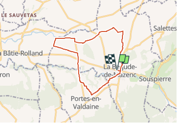
Randonnée de 13,8 km à découvrir à Auvergne-Rhône-Alpes, Drôme, La Bégude-de-Mazenc. Cette randonnée est proposée par pguillaume.
Description
Cette balade, en terrain plat et dégagé, est idéale pour les sorties avec de jeunes enfants ou de vrais débutants. Elle se fait dans une partie de ce bel amphithéâtre qu’est la plaine de la Valdaine, espace agricole prisé. Attention aux voitures !
Localisation
Pays :
France
Région :
Auvergne-Rhône-Alpes
Département/Province :
Drôme
Commune :
La Bégude-de-Mazenc
Localité :
Unknown
Départ:(Dec)
Départ:(UTM)
653527 ; 4934243 (31T) N.
Commentaires
Randonnées à proximité
![Randonnée Marche Portes-en-Valdaine - Portes en Valdaine la plaine 7km - Photo](https://media.geolcdn.com/t/375/260/ext.jpg?maxdim=2&url=https%3A%2F%2Fmedia.geolcdn.com%2Ff%2F521ae53d-ced6-46fa-9655-4eb3952c25ee.jpg)
![Marche Marche](https://static1.geolcdn.com/sitytour/trail-icons/101.png)
Portes en Valdaine la plaine 7km
Marche
Facile
(1)
Portes-en-Valdaine,
Auvergne-Rhône-Alpes,
Drôme,
France
![](/images/other/stat-length.png)
7,1 km | 8,2 km-effort
2h 0min
![](https://static1.geolcdn.com/siteimages/upload/files/16400158638029165_repeat_loop_refresh_sync_direction_icon.png)
Oui
![Randonnée Marche Portes-en-Valdaine - Portes-en-Valdaine Serre-de-Mirabel 11km. - Photo](https://media.geolcdn.com/t/375/260/ext.jpg?maxdim=2&url=https%3A%2F%2Fmedia.geolcdn.com%2Ff%2F89334076-0011-4fd6-a9cb-db05a56205b4.jpg)
![Marche Marche](https://static1.geolcdn.com/sitytour/trail-icons/101.png)
Portes-en-Valdaine Serre-de-Mirabel 11km.
Marche
Difficile
(1)
Portes-en-Valdaine,
Auvergne-Rhône-Alpes,
Drôme,
France
![](/images/other/stat-length.png)
10,8 km | 14,7 km-effort
3h 20min
![](https://static1.geolcdn.com/siteimages/upload/files/16400158638029165_repeat_loop_refresh_sync_direction_icon.png)
Oui
![Randonnée Marche La Touche - La Touche Crêtes de l'ysard 12km. - Photo](https://media.geolcdn.com/t/375/260/ext.jpg?maxdim=2&url=https%3A%2F%2Fmedia.geolcdn.com%2Ff%2Fb7717e93-9def-4e5d-8328-3e96528d5925.jpg)
![Marche Marche](https://static1.geolcdn.com/sitytour/trail-icons/101.png)
La Touche Crêtes de l'ysard 12km.
Marche
Difficile
(1)
La Touche,
Auvergne-Rhône-Alpes,
Drôme,
France
![](/images/other/stat-length.png)
12,1 km | 16,8 km-effort
3h 48min
![](https://static1.geolcdn.com/siteimages/upload/files/16400158638029165_repeat_loop_refresh_sync_direction_icon.png)
Oui
![Randonnée Marche La Bégude-de-Mazenc - La Bégude de Mazenc - Serre de Forillon - Photo](https://media.geolcdn.com/t/375/260/ext.jpg?maxdim=2&url=https%3A%2F%2Fstatic1.geolcdn.com%2Fsiteimages%2Fupload%2Ffiles%2F1553511878bg_sport_marche.png)
![Marche Marche](https://static1.geolcdn.com/sitytour/trail-icons/101.png)
La Bégude de Mazenc - Serre de Forillon
Marche
Moyen
(1)
La Bégude-de-Mazenc,
Auvergne-Rhône-Alpes,
Drôme,
France
![](/images/other/stat-length.png)
8,1 km | 12 km-effort
2h 30min
![](https://static1.geolcdn.com/siteimages/upload/files/16400158638029165_repeat_loop_refresh_sync_direction_icon.png)
Oui
![Randonnée Vélo La Bégude-de-Mazenc - La Roche St Secret - Photo](https://media.geolcdn.com/t/375/260/ext.jpg?maxdim=2&url=https%3A%2F%2Fstatic1.geolcdn.com%2Fsiteimages%2Fupload%2Ffiles%2F1524743154velo.jpg)
![Vélo Vélo](https://static1.geolcdn.com/sitytour/trail-icons/200.png)
La Roche St Secret
Vélo
Moyen
(1)
La Bégude-de-Mazenc,
Auvergne-Rhône-Alpes,
Drôme,
France
![](/images/other/stat-length.png)
46 km | 56 km-effort
2h 10min
![](https://static1.geolcdn.com/siteimages/upload/files/16400158638029165_repeat_loop_refresh_sync_direction_icon.png)
Oui
![Randonnée Marche La Bégude-de-Mazenc - Serre Forillon . La Begude de Mazenc 8km - Photo](https://media.geolcdn.com/t/375/260/ext.jpg?maxdim=2&url=https%3A%2F%2Fmedia.geolcdn.com%2Ff%2Fc6c6d47d-2b27-4a95-a6a2-66f0defa82f3.jpg)
![Marche Marche](https://static1.geolcdn.com/sitytour/trail-icons/101.png)
Serre Forillon . La Begude de Mazenc 8km
Marche
Difficile
La Bégude-de-Mazenc,
Auvergne-Rhône-Alpes,
Drôme,
France
![](/images/other/stat-length.png)
8,3 km | 12,3 km-effort
2h 44min
![](https://static1.geolcdn.com/siteimages/upload/files/16400158638029165_repeat_loop_refresh_sync_direction_icon.png)
Oui
![Randonnée A pied Portes-en-Valdaine - Randonnée Trail Portes en Valdaine - Photo](https://media.geolcdn.com/t/375/260/ext.jpg?maxdim=2&url=https%3A%2F%2Fstatic1.geolcdn.com%2Fsiteimages%2Fupload%2Ffiles%2F1545311037marcheuse_200dpi.jpg)
![A pied A pied](https://static1.geolcdn.com/sitytour/trail-icons/100.png)
Randonnée Trail Portes en Valdaine
A pied
Moyen
(1)
Portes-en-Valdaine,
Auvergne-Rhône-Alpes,
Drôme,
France
![](/images/other/stat-length.png)
19,4 km | 27 km-effort
6h 9min
![](https://static1.geolcdn.com/siteimages/upload/files/16400158638029165_repeat_loop_refresh_sync_direction_icon.png)
Oui
![Randonnée Marche La Touche - La Touche : Les Citelles et Serre Pointu 12km - Photo](https://media.geolcdn.com/t/375/260/ext.jpg?maxdim=2&url=https%3A%2F%2Fmedia.geolcdn.com%2Ff%2F6be75cc0-9945-4cf3-b3f9-69a08db1d316.jpg)
![Marche Marche](https://static1.geolcdn.com/sitytour/trail-icons/101.png)
La Touche : Les Citelles et Serre Pointu 12km
Marche
Difficile
La Touche,
Auvergne-Rhône-Alpes,
Drôme,
France
![](/images/other/stat-length.png)
12 km | 16,6 km-effort
4h 3min
![](https://static1.geolcdn.com/siteimages/upload/files/16400158638029165_repeat_loop_refresh_sync_direction_icon.png)
Oui
![Randonnée Marche La Touche - La Touche Mastaize 9km - Photo](https://media.geolcdn.com/t/375/260/ext.jpg?maxdim=2&url=https%3A%2F%2Fmedia.geolcdn.com%2Ff%2F7617f59d-4270-4583-9eab-9f2081c0076a.jpg)
![Marche Marche](https://static1.geolcdn.com/sitytour/trail-icons/101.png)
La Touche Mastaize 9km
Marche
Difficile
La Touche,
Auvergne-Rhône-Alpes,
Drôme,
France
![](/images/other/stat-length.png)
8,6 km | 10,7 km-effort
3h 24min
![](https://static1.geolcdn.com/siteimages/upload/files/16400158638029165_repeat_loop_refresh_sync_direction_icon.png)
Oui