![](/images/other/stat-length.png)
![Randonnée Marche Arcenant - Arcenant-Trou du Duc-Site Gallo-Romain-Maquis - Photo](https://media.geolcdn.com/t/1900/400/ext.pjpeg?maxdim=2&url=https%3A%2F%2Fstatic1.geolcdn.com%2Fsiteimages%2Fupload%2Ffiles%2F1553511878bg_sport_marche.png)
Arcenant-Trou du Duc-Site Gallo-Romain-Maquis
janussity
Utilisateur
![Longueur](/images/other/stat-length.png)
Longueur
11,6 km
![Altitude max](https://static1.geolcdn.com/siteimages/upload/files/1508320355ic_sort_altitude_max_24dp.png)
Altitude max
577 m
![Dénivelé positif](https://static1.geolcdn.com/siteimages/upload/files/1508320355ic_sort_den_pos_24dp.png)
Dénivelé positif
376 m
![Km-Effort](/images/other/stat-length.png)
Km-Effort
16,6 km
![Altitude min](https://static1.geolcdn.com/siteimages/upload/files/1508320355ic_sort_altitude_min_24dp.png)
Altitude min
325 m
![Dénivelé négatif](https://static1.geolcdn.com/siteimages/upload/files/1508320355ic_sort_den_neg_24dp.png)
Dénivelé négatif
375 m
![Boucle](https://static1.geolcdn.com/siteimages/upload/files/16400158638029165_repeat_loop_refresh_sync_direction_icon.png)
Boucle
Oui
Date de création :
2022-04-15 07:56:34.307
Dernière modification :
2022-04-15 08:10:54.715
![Marche](https://static1.geolcdn.com/sitytour/trail-icons/101.png)
3h46
Difficulté : Difficile
![Scannez ce code QR pour ouvrir la randonnée dans l'application SityTrail](https://capi.geolives.com/qq0zvz2zws4bq2lad0pu/sitytour/trails/3205251/qr.png?size=200)
Application GPS de randonnée GRATUITE
À propos
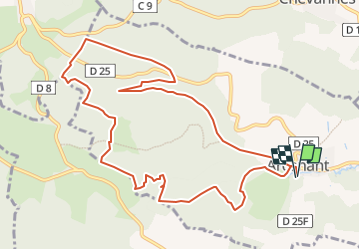
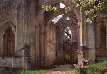
Randonnée Marche de 11,6 km à découvrir à Bourgogne-Franche-Comté, Côte-d'Or, Arcenant. Cette randonnée est proposée par janussity.
Description
Départ parking salle des fêtes d'Arcenant.
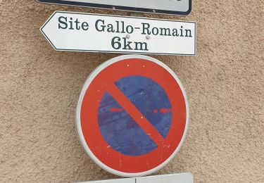
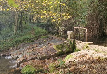
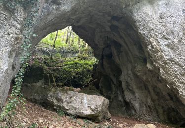
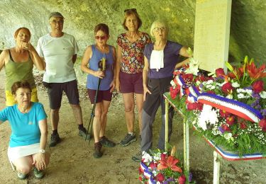
Montée régulière par la combe de Pertuis. Vue du Trou du Duc. Forêt d'Arcenant. Parcours boisé pour rejoindre l'Ecartelot (site gallo-romain). Maquis (monument) et retour Arcenant par combe Pourry.
Localisation
Pays :
France
Région :
Bourgogne-Franche-Comté
Département/Province :
Côte-d'Or
Commune :
Arcenant
Localité :
Unknown
Départ:(Dec)
Départ:(UTM)
639865 ; 5222112 (31T) N.
Commentaires
Randonnées à proximité
![Randonnée Marche Arcenant - Sentiers patrimoine et Marianne : Arcennant - Photo](https://media.geolcdn.com/t/375/260/6752da8e-ad96-4dd4-9b3a-2267488f42f7.jpg&format=jpg&maxdim=2)
![Marche Marche](https://static1.geolcdn.com/sitytour/trail-icons/101.png)
Sentiers patrimoine et Marianne : Arcennant
Marche
Moyen
Arcenant,
Bourgogne-Franche-Comté,
Côte-d'Or,
France
![](/images/other/stat-length.png)
9,8 km | 13,5 km-effort
2h 40min
![](https://static1.geolcdn.com/siteimages/upload/files/16400158638029165_repeat_loop_refresh_sync_direction_icon.png)
Oui
![Randonnée Marche Curtil-Vergy - Abbaye saint Vivant - Photo](https://media.geolcdn.com/t/375/260/040e75f6-3ed9-4472-88f3-28e2fffd2eca.jpg&format=jpg&maxdim=2)
![Marche Marche](https://static1.geolcdn.com/sitytour/trail-icons/101.png)
Abbaye saint Vivant
Marche
Curtil-Vergy,
Bourgogne-Franche-Comté,
Côte-d'Or,
France
![](/images/other/stat-length.png)
10 km | 14,3 km-effort
2h 43min
![](https://static1.geolcdn.com/siteimages/upload/files/16400158638029165_repeat_loop_refresh_sync_direction_icon.png)
Non
![Randonnée Marche Arcenant - A - Photo](https://media.geolcdn.com/t/375/260/e4ccacaa-0c16-4438-a54e-6dd5633e948a.jpg&format=jpg&maxdim=2)
![Marche Marche](https://static1.geolcdn.com/sitytour/trail-icons/101.png)
A
Marche
Très difficile
Arcenant,
Bourgogne-Franche-Comté,
Côte-d'Or,
France
![](/images/other/stat-length.png)
15 km | 20 km-effort
4h 11min
![](https://static1.geolcdn.com/siteimages/upload/files/16400158638029165_repeat_loop_refresh_sync_direction_icon.png)
Oui
![Randonnée A pied Bouilland - Tour de la Vallée du Rhoin - Photo](https://media.geolcdn.com/t/375/260/d493832b-3cd4-4631-ad38-006cf8bf3108.jpeg&format=jpg&maxdim=2)
![A pied A pied](https://static1.geolcdn.com/sitytour/trail-icons/100.png)
Tour de la Vallée du Rhoin
A pied
Facile
Bouilland,
Bourgogne-Franche-Comté,
Côte-d'Or,
France
![](/images/other/stat-length.png)
9,9 km | 15,1 km-effort
3h 25min
![](https://static1.geolcdn.com/siteimages/upload/files/16400158638029165_repeat_loop_refresh_sync_direction_icon.png)
Oui
![Randonnée Marche Arcenant - Arcenant - Sentier Marianne - Roches du Châtelet - Photo](https://media.geolcdn.com/t/375/260/01be1986-1ff9-45a8-8bb4-e4144fe03047.jpg&format=jpg&maxdim=2)
![Marche Marche](https://static1.geolcdn.com/sitytour/trail-icons/101.png)
Arcenant - Sentier Marianne - Roches du Châtelet
Marche
Difficile
Arcenant,
Bourgogne-Franche-Comté,
Côte-d'Or,
France
![](/images/other/stat-length.png)
24 km | 34 km-effort
5h 51min
![](https://static1.geolcdn.com/siteimages/upload/files/16400158638029165_repeat_loop_refresh_sync_direction_icon.png)
Oui
![Randonnée Marche Meuilley - meuilley - Photo](https://media.geolcdn.com/t/375/260/ext.jpg?maxdim=2&url=https%3A%2F%2Fstatic1.geolcdn.com%2Fsiteimages%2Fupload%2Ffiles%2F1553511878bg_sport_marche.png)
![Marche Marche](https://static1.geolcdn.com/sitytour/trail-icons/101.png)
meuilley
Marche
Très facile
(2)
Meuilley,
Bourgogne-Franche-Comté,
Côte-d'Or,
France
![](/images/other/stat-length.png)
13,3 km | 16,8 km-effort
3h 17min
![](https://static1.geolcdn.com/siteimages/upload/files/16400158638029165_repeat_loop_refresh_sync_direction_icon.png)
Oui
![Randonnée sport Bouilland - Bouilland site escalade - Photo](https://media.geolcdn.com/t/375/260/4c934685-1996-42fd-8ed0-a06b8add0cfb.jpg&format=jpg&maxdim=2)
Bouilland site escalade
sport
Très facile
Bouilland,
Bourgogne-Franche-Comté,
Côte-d'Or,
France
![](/images/other/stat-length.png)
10,5 km | 16,6 km-effort
Inconnu
![](https://static1.geolcdn.com/siteimages/upload/files/16400158638029165_repeat_loop_refresh_sync_direction_icon.png)
Oui
![Randonnée Marche Marey-lès-Fussey - Marey - Photo](https://media.geolcdn.com/t/375/260/f5c3d4eb-85a1-4cfa-8def-8457350b3366.jpg&format=jpg&maxdim=2)
![Marche Marche](https://static1.geolcdn.com/sitytour/trail-icons/101.png)
Marey
Marche
Moyen
Marey-lès-Fussey,
Bourgogne-Franche-Comté,
Côte-d'Or,
France
![](/images/other/stat-length.png)
9,3 km | 11,7 km-effort
2h 36min
![](https://static1.geolcdn.com/siteimages/upload/files/16400158638029165_repeat_loop_refresh_sync_direction_icon.png)
Oui
![Randonnée Marche Arcenant - Arcenant 19/06 - Photo](https://media.geolcdn.com/t/375/260/d9ed6864-d418-4320-bd9f-bd951789b73f.jpg&format=jpg&maxdim=2)
![Marche Marche](https://static1.geolcdn.com/sitytour/trail-icons/101.png)
Arcenant 19/06
Marche
Facile
Arcenant,
Bourgogne-Franche-Comté,
Côte-d'Or,
France
![](/images/other/stat-length.png)
10,2 km | 13,9 km-effort
3h 15min
![](https://static1.geolcdn.com/siteimages/upload/files/16400158638029165_repeat_loop_refresh_sync_direction_icon.png)
Oui