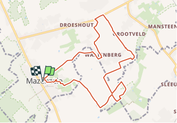
![](/images/other/stat-length.png)
![Randonnée Marche Opwijk - 20220416 Hyacintentocht lus 10 km v2 - Photo](https://media.geolcdn.com/t/1900/400/ae2ac5aa-00d1-4a9a-96be-89b4020581ac.webp&format=pjpeg&maxdim=2)
20220416 Hyacintentocht lus 10 km v2
ElGino
Utilisateur
![Longueur](/images/other/stat-length.png)
![Altitude max](https://static1.geolcdn.com/siteimages/upload/files/1508320355ic_sort_altitude_max_24dp.png)
![Dénivelé positif](https://static1.geolcdn.com/siteimages/upload/files/1508320355ic_sort_den_pos_24dp.png)
![Km-Effort](/images/other/stat-length.png)
![Altitude min](https://static1.geolcdn.com/siteimages/upload/files/1508320355ic_sort_altitude_min_24dp.png)
![Dénivelé négatif](https://static1.geolcdn.com/siteimages/upload/files/1508320355ic_sort_den_neg_24dp.png)
![Boucle](https://static1.geolcdn.com/siteimages/upload/files/16400158638029165_repeat_loop_refresh_sync_direction_icon.png)
![Marche](https://static1.geolcdn.com/sitytour/trail-icons/101.png)
2h06
Difficulté : Moyen
![Scannez ce code QR pour ouvrir la randonnée dans l'application SityTrail](https://capi.geolives.com/qq0zvz2zws4bq2lad0pu/sitytour/trails/3201514/qr.png?size=200)
Application GPS de randonnée GRATUITE
À propos
Randonnée Marche de 9,8 km à découvrir à Flandre, Brabant flamand, Opwijk. Cette randonnée est proposée par ElGino.
Description
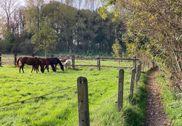
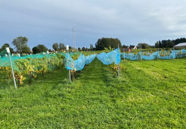
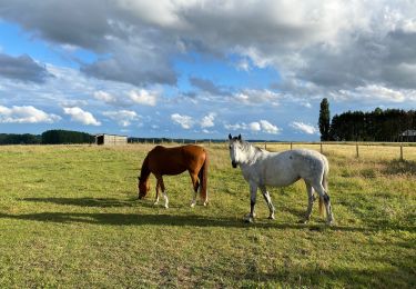
Mazenzele dorp langs Knipoog naar Waaienberg. Kerkwegje naar bosje v Willem, vervolgens rechts bosje uit maken een ruime U via veldbanen naar nieuwe Wegeltje 53. Vervolgen via Waaienberg, naar Natuurpunt knpt 200 Paddebroeken en komen parallel met uitgang Geboortebos. Sluiten aan op eerste deel van route. Totaal 9,8 km.
Localisation
Commentaires
Randonnées à proximité
![Randonnée Randonnée équestre Opwijk - Mazenzele- Meldert vanuit De Kleine Deugd - Photo](https://media.geolcdn.com/t/375/260/ext.jpg?maxdim=2&url=https%3A%2F%2Fstatic1.geolcdn.com%2Fsiteimages%2Fupload%2Ffiles%2F1524743154cheval.jpg)
![Randonnée équestre Randonnée équestre](https://static1.geolcdn.com/sitytour/trail-icons/301.png)
Randonnée équestre
![](/images/other/stat-length.png)
![](https://static1.geolcdn.com/siteimages/upload/files/16400158638029165_repeat_loop_refresh_sync_direction_icon.png)
![Randonnée A pied Alost - Kersenwandeling - Photo](https://media.geolcdn.com/t/375/260/ea2bda03-7aab-439e-ac2f-d6e170d9c15f.jpeg&format=jpg&maxdim=2)
![A pied A pied](https://static1.geolcdn.com/sitytour/trail-icons/100.png)
A pied
![](/images/other/stat-length.png)
![](https://static1.geolcdn.com/siteimages/upload/files/16400158638029165_repeat_loop_refresh_sync_direction_icon.png)
![Randonnée A pied Lebbeke - Mennenpad - Photo](https://media.geolcdn.com/t/375/260/9ca09073-979e-439c-9e92-d1334cfb6bb5.jpeg&format=jpg&maxdim=2)
![A pied A pied](https://static1.geolcdn.com/sitytour/trail-icons/100.png)
A pied
![](/images/other/stat-length.png)
![](https://static1.geolcdn.com/siteimages/upload/files/16400158638029165_repeat_loop_refresh_sync_direction_icon.png)
![Randonnée Marche Asse - Asse 25 km - Photo](https://media.geolcdn.com/t/375/260/93373654-1789-4a22-a980-4e4078e012f6.jpg&format=jpg&maxdim=2)
![Marche Marche](https://static1.geolcdn.com/sitytour/trail-icons/101.png)
![Randonnée Marche Asse - S-GR Groene Gordel: Mollem - Ternat - Photo](https://media.geolcdn.com/t/375/260/6faef7af-0d0f-4faa-bb47-f1d7e98a3199.jpeg&format=jpg&maxdim=2)
![Marche Marche](https://static1.geolcdn.com/sitytour/trail-icons/101.png)
Marche
![](/images/other/stat-length.png)
![](https://static1.geolcdn.com/siteimages/upload/files/16400158638029165_repeat_loop_refresh_sync_direction_icon.png)
![Randonnée Marche Asse - Asse 10,7 km - Photo](https://media.geolcdn.com/t/375/260/0cbdcab9-dd9e-496b-b40e-0779d93b5c23.jpg&format=jpg&maxdim=2)
![Marche Marche](https://static1.geolcdn.com/sitytour/trail-icons/101.png)
Marche
![](/images/other/stat-length.png)
![](https://static1.geolcdn.com/siteimages/upload/files/16400158638029165_repeat_loop_refresh_sync_direction_icon.png)
![Randonnée Marche Asse - Asse Kravaalbos 6,1 km - Photo](https://media.geolcdn.com/t/375/260/25a33a83-112b-4dd2-b149-e23b8049088b.jpg&format=jpg&maxdim=2)
![Marche Marche](https://static1.geolcdn.com/sitytour/trail-icons/101.png)
Marche
![](/images/other/stat-length.png)
![](https://static1.geolcdn.com/siteimages/upload/files/16400158638029165_repeat_loop_refresh_sync_direction_icon.png)
![Randonnée Marche Asse - Asbeek 8 km - Photo](https://media.geolcdn.com/t/375/260/c9378bb3-5963-4357-b9f0-3509a536491f.jpg&format=jpg&maxdim=2)
![Marche Marche](https://static1.geolcdn.com/sitytour/trail-icons/101.png)
Marche
![](/images/other/stat-length.png)
![](https://static1.geolcdn.com/siteimages/upload/files/16400158638029165_repeat_loop_refresh_sync_direction_icon.png)
![Randonnée Marche Alost - 20221204 Verkenning Baardegem Winninck - Photo](https://media.geolcdn.com/t/375/260/2707ccb6-80d7-4bb7-8678-8ecaad5c771c.jpg&format=jpg&maxdim=2)
![Marche Marche](https://static1.geolcdn.com/sitytour/trail-icons/101.png)
Marche
![](/images/other/stat-length.png)
![](https://static1.geolcdn.com/siteimages/upload/files/16400158638029165_repeat_loop_refresh_sync_direction_icon.png)