![](/images/other/stat-length.png)
![Randonnée Marche Lagnes - PF-Lagnes - Sentier botanique - Le Mur de la Peste - La Tête du Soldat - DD - Photo](https://media.geolcdn.com/t/1900/400/3379eca8-2f59-4c0c-b19b-ccc327c00164.jpg&format=pjpeg&maxdim=2)
PF-Lagnes - Sentier botanique - Le Mur de la Peste - La Tête du Soldat - DD
MicDul
Utilisateur GUIDE
![Longueur](/images/other/stat-length.png)
![Altitude max](https://static1.geolcdn.com/siteimages/upload/files/1508320355ic_sort_altitude_max_24dp.png)
![Dénivelé positif](https://static1.geolcdn.com/siteimages/upload/files/1508320355ic_sort_den_pos_24dp.png)
![Km-Effort](/images/other/stat-length.png)
![Altitude min](https://static1.geolcdn.com/siteimages/upload/files/1508320355ic_sort_altitude_min_24dp.png)
![Dénivelé négatif](https://static1.geolcdn.com/siteimages/upload/files/1508320355ic_sort_den_neg_24dp.png)
![Boucle](https://static1.geolcdn.com/siteimages/upload/files/16400158638029165_repeat_loop_refresh_sync_direction_icon.png)
![Marche](https://static1.geolcdn.com/sitytour/trail-icons/101.png)
3h12
Difficulté : Difficile
![Scannez ce code QR pour ouvrir la randonnée dans l'application SityTrail](https://capi.geolives.com/qq0zvz2zws4bq2lad0pu/sitytour/trails/3199599/qr.png?size=200)
Application GPS de randonnée GRATUITE
À propos
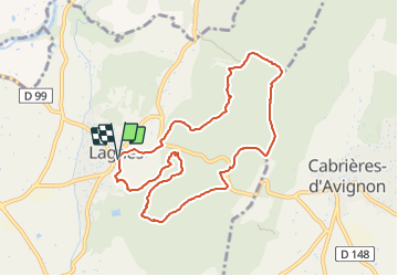
Randonnée Marche de 9,9 km à découvrir à Provence-Alpes-Côte d'Azur, Vaucluse, Lagnes. Cette randonnée est proposée par MicDul.
Description
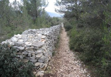
Du village de Lagnes (Place de l'Eglise), on suit d'abord le sentier botanique (très instructif) puis on part vers le Mur de la Peste (GRP puis GR) que l'on longe jusqu'à une citerne incendie (marquée 122) pour s'engager dans un joli vallon en suivant les panneaux directionnels vers Lagnes.
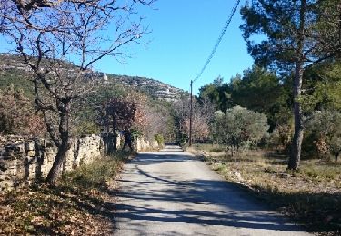
On termine après un raidillon par une descente via une route forestière pour rejoindre Lagnes.
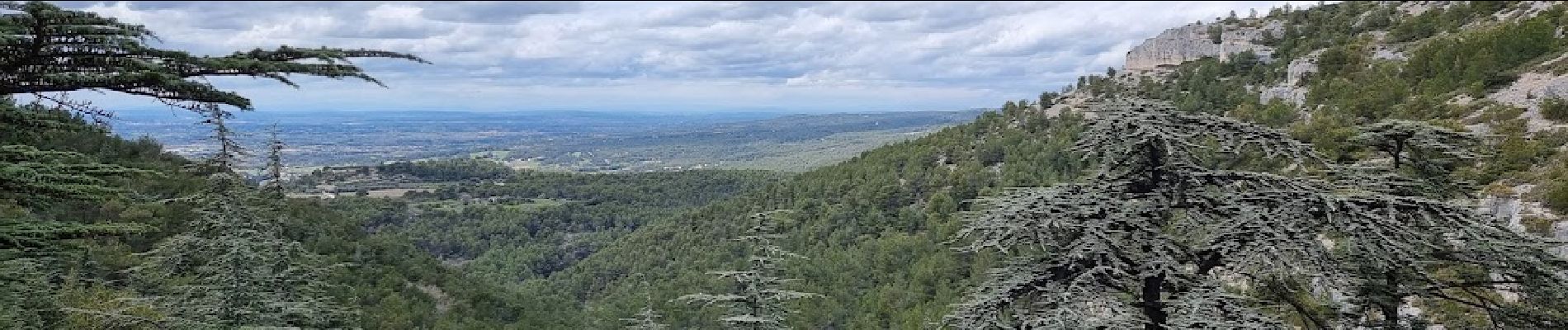
Beaux paysages, beaucoup de cèdres de l'Atlas majestueux
Une jolie rando assez facile
Localisation
Commentaires
Randonnées à proximité
![Randonnée Marche Fontaine-de-Vaucluse - Fontaine de Vaucluse par l'aven de Valescure, les crêtes et le chateau - Photo](https://media.geolcdn.com/t/375/260/151070e1-18c8-4062-b1e4-7770840cd66e.jpg&format=jpg&maxdim=2)
![Marche Marche](https://static1.geolcdn.com/sitytour/trail-icons/101.png)
Marche
![](/images/other/stat-length.png)
![](https://static1.geolcdn.com/siteimages/upload/files/16400158638029165_repeat_loop_refresh_sync_direction_icon.png)
![Randonnée Marche Lagnes - Lagnes Tête du Soldat Mur de la peste Esperacons - Photo](https://media.geolcdn.com/t/375/260/a1cbca5d-1ba7-4e0a-a45d-e364265b058f.jpg&format=jpg&maxdim=2)
![Marche Marche](https://static1.geolcdn.com/sitytour/trail-icons/101.png)
Marche
![](/images/other/stat-length.png)
![](https://static1.geolcdn.com/siteimages/upload/files/16400158638029165_repeat_loop_refresh_sync_direction_icon.png)
![Randonnée Marche Lagnes - Lagnes - La Tête du Soldat - Mur de la Peste - Photo](https://media.geolcdn.com/t/375/260/ext.jpg?maxdim=2&url=https%3A%2F%2Fservices.sitytrail.com%2FGeolivesWS%2FDownloadMedia.ashx%3FTrailID%3D103456%26Media%3D5577_2.jpg)
![Marche Marche](https://static1.geolcdn.com/sitytour/trail-icons/101.png)
Marche
![](/images/other/stat-length.png)
![](https://static1.geolcdn.com/siteimages/upload/files/16400158638029165_repeat_loop_refresh_sync_direction_icon.png)
![Randonnée Marche Fontaine-de-Vaucluse - Ballade le long du canal de Carpentras - Photo](https://media.geolcdn.com/t/375/260/3ef0eb2a-23ef-4d53-a230-1b96fa5cca74.jpg&format=jpg&maxdim=2)
![Marche Marche](https://static1.geolcdn.com/sitytour/trail-icons/101.png)
Marche
![](/images/other/stat-length.png)
![](https://static1.geolcdn.com/siteimages/upload/files/16400158638029165_repeat_loop_refresh_sync_direction_icon.png)
![Randonnée V.T.C. Lagnes - La coutelière <> L’Isle Sur La Sorgue - Photo](https://media.geolcdn.com/t/375/260/ext.jpg?maxdim=2&url=https%3A%2F%2Fstatic1.geolcdn.com%2Fsiteimages%2Fupload%2Ffiles%2F1524743154velo.jpg)
![V.T.C. V.T.C.](https://static1.geolcdn.com/sitytour/trail-icons/203.png)
V.T.C.
![](/images/other/stat-length.png)
![](https://static1.geolcdn.com/siteimages/upload/files/16400158638029165_repeat_loop_refresh_sync_direction_icon.png)
![Marche Marche](https://static1.geolcdn.com/sitytour/trail-icons/101.png)
Marche
![](/images/other/stat-length.png)
![](https://static1.geolcdn.com/siteimages/upload/files/16400158638029165_repeat_loop_refresh_sync_direction_icon.png)
![Randonnée Marche Fontaine-de-Vaucluse - di 22022015 lagnes bondelon - Photo](https://media.geolcdn.com/t/375/260/ext.jpg?maxdim=2&url=https%3A%2F%2Fservices.sitytrail.com%2FGeolivesWS%2FDownloadMedia.ashx%3FTrailID%3D388879%26Media%3Dfix__20150222143029.jpg)
![Marche Marche](https://static1.geolcdn.com/sitytour/trail-icons/101.png)
Marche
![](/images/other/stat-length.png)
![](https://static1.geolcdn.com/siteimages/upload/files/16400158638029165_repeat_loop_refresh_sync_direction_icon.png)
![Randonnée Marche Fontaine-de-Vaucluse - Fontaine du Vaucluse - Photo](https://media.geolcdn.com/t/375/260/ext.jpg?maxdim=2&url=https%3A%2F%2Fstatic1.geolcdn.com%2Fsiteimages%2Fupload%2Ffiles%2F1553511878bg_sport_marche.png)
![Marche Marche](https://static1.geolcdn.com/sitytour/trail-icons/101.png)
Marche
![](/images/other/stat-length.png)
![](https://static1.geolcdn.com/siteimages/upload/files/16400158638029165_repeat_loop_refresh_sync_direction_icon.png)
![Randonnée Vélo L'Isle-sur-la-Sorgue - La Sorguette - Photo](https://media.geolcdn.com/t/375/260/ext.jpg?maxdim=2&url=https%3A%2F%2Fstatic1.geolcdn.com%2Fsiteimages%2Fupload%2Ffiles%2F1524743154velo.jpg)
![Vélo Vélo](https://static1.geolcdn.com/sitytour/trail-icons/200.png)
Vélo
![](/images/other/stat-length.png)
![](https://static1.geolcdn.com/siteimages/upload/files/16400158638029165_repeat_loop_refresh_sync_direction_icon.png)